U.S. flag

An official website of the United States government

Images

Explore water-related photography, imagery, and illustrations.

Filter Total Items: 2553
Two people walking up an orange creek bed.
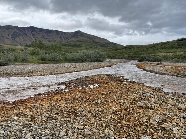
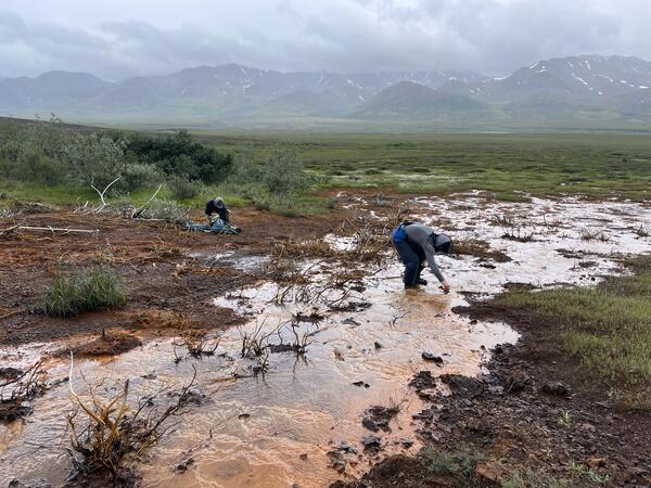
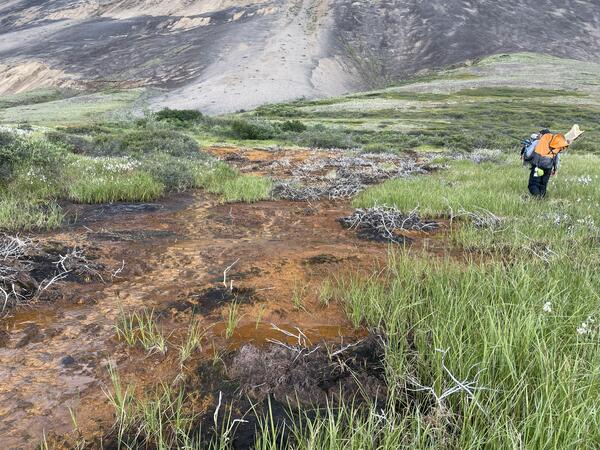
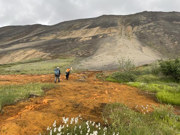
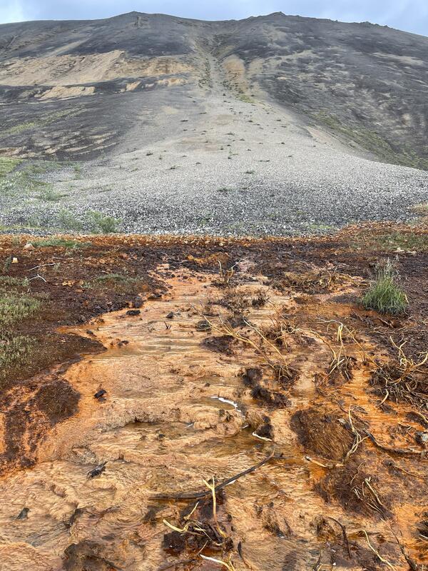
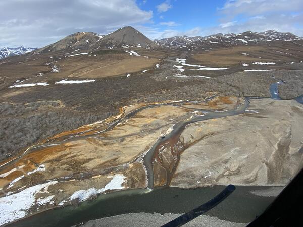
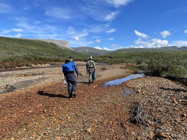
Researchers walking to a site to sample rusting in the Nakolikurok Creek Watershed

Orange streams are increasingly common in the Brooks Range of northern Alaska. The orange stream color reflects oxidized iron, but also often indicates elevated heavy metal concentrations. Our ongoing study aims to document these occurrences and the timing of their onset.

Orange streams are increasingly common in the Brooks Range of northern Alaska. The orange stream color reflects oxidized iron, but also often indicates elevated heavy metal concentrations. Our ongoing study aims to document these occurrences and the timing of their onset.

Orange stained rock along a creek.
Orange staining in the braidplain of the Nakolikurok Creek

Orange streams are increasingly common in the Brooks Range of northern Alaska. The orange stream color reflects oxidized iron, but also often indicates elevated heavy metal concentrations. Our ongoing study aims to document these occurrences and the timing of their onset.

Orange streams are increasingly common in the Brooks Range of northern Alaska. The orange stream color reflects oxidized iron, but also often indicates elevated heavy metal concentrations. Our ongoing study aims to document these occurrences and the timing of their onset.

Exterior of a building and front parking lot with blue sky in the background
New USGS Hydrologic Instrumentation Facility in Tuscaloosa, Alabama

The new Hydrologic Instrumentation Facility (HIF) on the University of Alabama Campus at Tuscaloosa, AL. The new facility is a national USGS capability that includes:

Two people sampling water from an orange creek.
Two scientists sample the orange water of a seep in the Kelly River Watershed, Alaska

Orange streams are increasingly common in the Brooks Range of northern Alaska. The orange stream color reflects oxidized iron, but also often indicates elevated heavy metal concentrations. Our ongoing study aims to document these occurrences and the timing of their onset.

Orange streams are increasingly common in the Brooks Range of northern Alaska. The orange stream color reflects oxidized iron, but also often indicates elevated heavy metal concentrations. Our ongoing study aims to document these occurrences and the timing of their onset.

Person walking through green grass next to an orange creek.
A scientist walks uphill towards the source of an orange seep

Orange streams are increasingly common in the Brooks Range of northern Alaska. The orange stream color reflects oxidized iron, but also often indicates elevated heavy metal concentrations. Our ongoing study aims to document these occurrences and the timing of their onset.

Orange streams are increasingly common in the Brooks Range of northern Alaska. The orange stream color reflects oxidized iron, but also often indicates elevated heavy metal concentrations. Our ongoing study aims to document these occurrences and the timing of their onset.

Two people walking across and orange seep.
Two scientists investigating the source of an orange seep

Orange streams are increasingly common in the Brooks Range of northern Alaska. The orange stream color reflects oxidized iron, but also often indicates elevated heavy metal concentrations. Our ongoing study aims to document these occurrences and the timing of their onset.

Orange streams are increasingly common in the Brooks Range of northern Alaska. The orange stream color reflects oxidized iron, but also often indicates elevated heavy metal concentrations. Our ongoing study aims to document these occurrences and the timing of their onset.

Orange stream with brown mountain in background.
Orange staining and blackened vegetation where a seep emerges from a debris fan

Orange streams are increasingly common in the Brooks Range of northern Alaska. The orange stream color reflects oxidized iron, but also often indicates elevated heavy metal concentrations. Our ongoing study aims to document these occurrences and the timing of their onset.

Orange streams are increasingly common in the Brooks Range of northern Alaska. The orange stream color reflects oxidized iron, but also often indicates elevated heavy metal concentrations. Our ongoing study aims to document these occurrences and the timing of their onset.

Two USGS employees sampling surface water in the dark during a rainstorm.
ABQ_Night_Sampling
ABQ_Night_Sampling
ABQ_Night_Sampling

USGS employees surface water sampling during evening monsoon storm in July 2024 at Adobe Acres Inflow at Albuquerque, New Mexico – USGS-350100106410810.

USGS employees surface water sampling during evening monsoon storm in July 2024 at Adobe Acres Inflow at Albuquerque, New Mexico – USGS-350100106410810.

Still, brown water covered on the bottom half by a thin layer of light green algae. The sky is clear.
OutfallAlameda_w-Algae

Photograph of stormwater outfall sampling location, Alameda Pump Station Outflow – USGS-351146106382801

Photograph of stormwater outfall sampling location, Alameda Pump Station Outflow – USGS-351146106382801

Large tilting flume inside a hydraulics laboratory seen from above.
Tilting flume in the USGS Hydrologic Instrumentation Facility's new hydraulics laboratory
Person standing inside walk-in temperature chamber
Walk-in temperature chamber at the USGS Hydrologic Instrumentation Facility
Interior laboratory room with counters and cabinets.
Wet chemistry lab at the USGS Hydrologic Instrumentation Facility
Tanks and walkways inside a large hydraulics laboratory.
Hydraulics lab at the USGS Hydrologic Instrumentation Facility

The hydraulics lab at the USGS Hydrologic Instrumentation Facility, complete with tow tank, tilting flume, and wave-generating test basin, near completion in June 2024.

The hydraulics lab at the USGS Hydrologic Instrumentation Facility, complete with tow tank, tilting flume, and wave-generating test basin, near completion in June 2024.

USGS Scientists Deploy to New Mexico Fire to Enhance Water Monitoring

USGS Water and Fire Technicians team members, Jorge Gonzalez and Efren Alvarado, made repairs to the Buck Mountain precipitation gage during the Blue 2 Fire near Alto, New Mexico on June 7, 2024. This station, along with similar gages, provides critical real-time rainfall data to the National Weather Service and local emergency managers.

USGS Water and Fire Technicians team members, Jorge Gonzalez and Efren Alvarado, made repairs to the Buck Mountain precipitation gage during the Blue 2 Fire near Alto, New Mexico on June 7, 2024. This station, along with similar gages, provides critical real-time rainfall data to the National Weather Service and local emergency managers.

Decorative image of a river seen from above.
Relative elevation model (REM) of Beaver Creek, Liberty County, MT

This map shows the intricate fluvial landforms (e.g., meanders, relic stream channels, meander cutoffs) of Beaver Creek, Liberty County, MT. Relative elevation models show elevation of a landscape relative to the elevation of an adjacent river.

This map shows the intricate fluvial landforms (e.g., meanders, relic stream channels, meander cutoffs) of Beaver Creek, Liberty County, MT. Relative elevation models show elevation of a landscape relative to the elevation of an adjacent river.

Orange river on a brown landscape and snowy mountains in the background.
An orange tributary of the Kugururok River, Noatak National Preserve in Alaska

Orange streams are increasingly common in the Brooks Range of northern Alaska. The orange stream color reflects oxidized iron, but also often indicates elevated heavy metal concentrations. Our ongoing study aims to document these occurrences and the timing of their onset.

Orange streams are increasingly common in the Brooks Range of northern Alaska. The orange stream color reflects oxidized iron, but also often indicates elevated heavy metal concentrations. Our ongoing study aims to document these occurrences and the timing of their onset.

A member of the USGS Water and Fire Technicians Team repairs a streamgage during the Blue 2 Fire near Alto, New Mexico.
Repairing a streamgage during the Blue 2 Fire near Alto, New Mexico

A member of the USGS Water and Fire Technicians Team repairs a streamgage during the Blue 2 Fire near Alto, New Mexico. 

The USGS Water and Fire Technicians Team prepares to evaluate precipitation and streamflow gauges during the Blue 2 Fire.
The USGS Water and Fire Technicians Team prepares to evaluate precipitation and streamflow gauges during the Blue 2 Fire near Alto, New Mexico.
Two scientists stand on dock next two river holding water samples.
Sampling the Mississippi River above Vicksburg at Mile 438

USGS scientists out on the Mississippi River above Vicksburg use a D-99 sampler to collect sediment and water-quality samples from the large inland river.

Was this page helpful?