
Numerous rivers flooded during a significant September 2013 rain event along Colorado's Front Range, damaging or destroying several USGS streamgages. In response, USGS field crews measured flood flows, made gage repairs, and assessed sites to replace those gages destroyed.
Images
Explore water-related photography, imagery, and illustrations.
Filter Total Items: 2560

Boulder, Colo., Flooding East of 63rd Street
Numerous rivers flooded during a significant September 2013 rain event along Colorado's Front Range, damaging or destroying several USGS streamgages. In response, USGS field crews measured flood flows, made gage repairs, and assessed sites to replace those gages destroyed.

Flood Aftermath, Boulder, Colo.
This flooded culvert is located on Monarch Road just east of the Diagonal Highway in Boulder, Colo.
This flooded culvert is located on Monarch Road just east of the Diagonal Highway in Boulder, Colo.

A Flooded Field in East Boulder, Colo.
Numerous rivers flooded during a significant September 2013 rain event along Colorado's Front Range, damaging or destroying several USGS streamgages. In response, USGS field crews measured flood flows, made gage repairs, and assessed sites to replace those gages destroyed.
Numerous rivers flooded during a significant September 2013 rain event along Colorado's Front Range, damaging or destroying several USGS streamgages. In response, USGS field crews measured flood flows, made gage repairs, and assessed sites to replace those gages destroyed.

Lost Dog Creek
A turbid Lost Dog Creek tumbles down steep slopes before feeding Lake Oswego.
A turbid Lost Dog Creek tumbles down steep slopes before feeding Lake Oswego.

Tanner Creek
Tanner Creek outfall delivers stormwater runoff with insecticides to Tanner Creek, tributary of the Willamette River
Tanner Creek outfall delivers stormwater runoff with insecticides to Tanner Creek, tributary of the Willamette River

Loch Vale Watershed
Loch Vale Watershed in the Rocky Mountain National Park, Colorado.
Loch Vale Watershed in the Rocky Mountain National Park, Colorado.

Loch Vale Watershed
Loch Vale Watershed in the Rocky Mountain National Park, Colorado.
Loch Vale Watershed in the Rocky Mountain National Park, Colorado.

Loch Vale Watershed
Loch Vale Watershed in the Rocky Mountain National Park, Colorado.
Loch Vale Watershed in the Rocky Mountain National Park, Colorado.

Salmon Creek
Salmon Creek at Bruno Road near Seward, AK; Paul Schauer running a level survey for the streambed scour project.
Salmon Creek at Bruno Road near Seward, AK; Paul Schauer running a level survey for the streambed scour project.
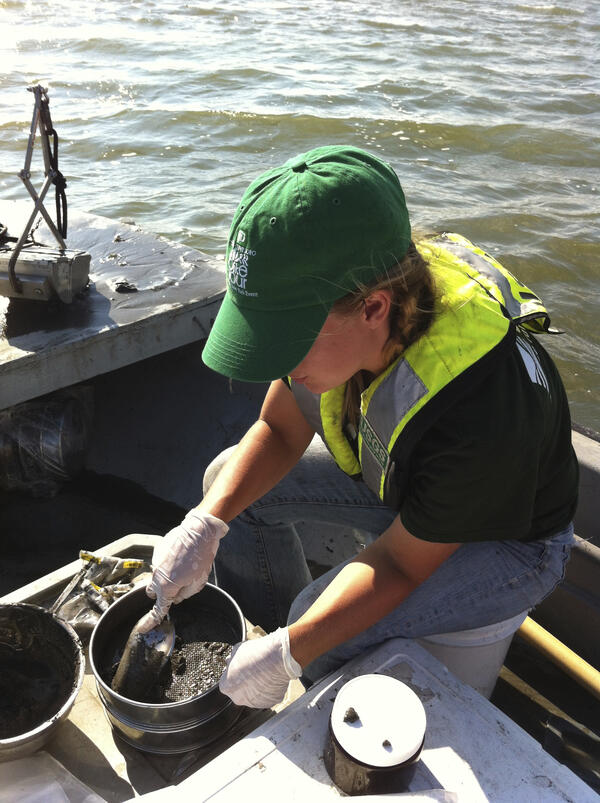
USGS Employee Sediment Sampling On Barnegat Bay, NJ After Super Storm
USGS Employee Sediment Sampling On Barnegat Bay, NJ After Super StormA USGS employee, is performing a sediment sampling on Barnegat Bay, NJ after Super Storm Sandy.
USGS Employee Sediment Sampling On Barnegat Bay, NJ After Super Storm
USGS Employee Sediment Sampling On Barnegat Bay, NJ After Super StormA USGS employee, is performing a sediment sampling on Barnegat Bay, NJ after Super Storm Sandy.

Oil Pipeline in Alaska, August 2013
USGS scientists are working alongside University researchers in Alaska to understand how groundwater and permafrost conditions change over time due to seasonal variations and climate change. August 2013 view of oil pipeline.
USGS scientists are working alongside University researchers in Alaska to understand how groundwater and permafrost conditions change over time due to seasonal variations and climate change. August 2013 view of oil pipeline.

Ebony Jewelwing (Calopteryx maculata) Male
An ebony jewelwing (Calopteryx maculata) perched on a blade of grass in the foreground with a flowing stream in the background
An ebony jewelwing (Calopteryx maculata) perched on a blade of grass in the foreground with a flowing stream in the background

South Toe River
South Toe River near Celo, NC, Oran Mosteller streamgaging.
South Toe River near Celo, NC, Oran Mosteller streamgaging.

Sediment sampling - Long Island
Sediment sampling off the coast of Long Island, NY.
Sediment sampling off the coast of Long Island, NY.

Rock Creek
Rock Creek at Sherrill Drive, Washington, DC; staff gage.
Rock Creek at Sherrill Drive, Washington, DC; staff gage.

Summer Intern
Summer Intern Tyler Choe cleaning the sediment out of the beaker.
Summer Intern Tyler Choe cleaning the sediment out of the beaker.

Summer Intern
Summer Intern Zachary Auman seeing the solutions for the sediment in the graduated cylinder.
Summer Intern Zachary Auman seeing the solutions for the sediment in the graduated cylinder.

Patuxent Research Center
View of Patuxent Lake.

Big Darby Creek flows through a heavily wooded area
Big Darby Creek flows through a heavily wooded areaBig Darby Creek is near Lake Darby, Ohio. Find out about the water quality of this stream and others in the Midwest studied by the Midwest Stream Quality Assessment.
Big Darby Creek flows through a heavily wooded area
Big Darby Creek flows through a heavily wooded areaBig Darby Creek is near Lake Darby, Ohio. Find out about the water quality of this stream and others in the Midwest studied by the Midwest Stream Quality Assessment.

Flows through intensively row-cropped land
Minnesota Valley Creek Ditch near Loess Bluffs National Wildlife Refuge flows through intensively row-cropped agricultural land. Find out more about this and other agricultural streams sampled by the USGS Midwest Stream Quality Assessment.
Minnesota Valley Creek Ditch near Loess Bluffs National Wildlife Refuge flows through intensively row-cropped agricultural land. Find out more about this and other agricultural streams sampled by the USGS Midwest Stream Quality Assessment.

Flooding on Hidewood Creek near Estelline, SD
Localized flooding on Hidewood Creek near Estelline, SD, on June 23, 2013. Severe storms during June 21-22, 2013, in eastern South Dakota resulted in high flows in several streams across the area. The peak discharge on Hidewood Creek (streamgage 06479640) from this storm event was about 4,200 cubic feet per second.
Localized flooding on Hidewood Creek near Estelline, SD, on June 23, 2013. Severe storms during June 21-22, 2013, in eastern South Dakota resulted in high flows in several streams across the area. The peak discharge on Hidewood Creek (streamgage 06479640) from this storm event was about 4,200 cubic feet per second.