
U.S. flag

An official website of the United States government

Natural Hazards Mission Area

Every year in the United States, natural hazards threaten lives and livelihoods and result in billions of dollars in damage. We work with many partners to monitor, assess, and conduct targeted research on a wide range of natural hazards so that policymakers and the public have the understanding they need to enhance preparedness, response, and resilience.

News

Decades of satellite imagery show how groins reshape California beaches

Decades of satellite imagery show how groins reshape California beaches

Morphodynamics of dune-based coastal flood mitigation under sea-level rise

Morphodynamics of dune-based coastal flood mitigation under sea-level rise

A mid-ocean ridge revealed by 3D magnetic modeling: New geologic map of Escanaba Trough

A mid-ocean ridge revealed by 3D magnetic modeling: New geologic map of Escanaba Trough

Publications

Simulation-based scenario ShakeMaps for large magnitude (MW6.5+) crustal earthquakes on the Seattle, Tacoma, and southern Whidbey Island faults, Washington, USA Simulation-based scenario ShakeMaps for large magnitude (MW6.5+) crustal earthquakes on the Seattle, Tacoma, and southern Whidbey Island faults, Washington, USA

Scenario ground‐motion maps based on empirical ground‐motion models (GMMs) provide a rapid and generally reliable means of estimating the amplitude and distribution of earthquake shaking. However, because GMMs are designed for broad applicability, they often rely on simplified representations of Earth structure, which can limit their accuracy in regions with complex source, path, and...
Authors
Ian P. Stone, Erin A. Wirth, Alex R. Grant, Julia Grossman, Arthur D. Frankel

Testing characteristic magnitude distributions in modern PSHA models Testing characteristic magnitude distributions in modern PSHA models

The characteristic magnitude distribution hypothesis predicts a higher rate of large earthquakes than a Gutenberg–Richter extrapolation of the small‐earthquake rate would imply. Characteristic magnitude distributions have been commonly applied to faults in probabilistic seismic hazard analysis (PSHA), and in modern models they can emerge from the way short‐term seismicity constraints are...
Authors
Morgan T. Page, Kevin Ross Milner, Edward H. Field

Velocity-independent dry friction on mica: A realization of ideal Amontons-Coulomb friction Velocity-independent dry friction on mica: A realization of ideal Amontons-Coulomb friction

The Amontons-Coulomb friction law assumes that the frictional force between materials is independent of sliding velocity. However, as Coulomb noted, this is a rough approximation, and a second-order dependence of friction on the logarithm of sliding velocity is incorporated in a commonly used ‘rate- and state-dependent’ friction representation. Here we conduct shear experiments on mica...
Authors
Hiroshi Sakuma, Diane E. Moore, David A. Lockner, Toshihiro Kogure

Science

Rainfall and Landslides in Northern California
A summary of recent and past landslides and debris flows caused by rainfall in northern California, and links to current shallow landslide monitoring.
Rainfall and Landslides in Northern California

Rainfall and Landslides in Northern California

A summary of recent and past landslides and debris flows caused by rainfall in northern California, and links to current shallow landslide monitoring.
Learn More

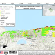
2026 Venezuela Sequence Earthquake-Triggered Landslide Hazards

On Wednesday, June 24th, 2026, a pair of earthquakes of Magnitude 7.2 and Magnitude 7.5 occurred in northern Venezuela, west of Caracas. The U.S. Geological Survey (USGS) Ground Failure product estimated that landslides triggered by this earthquake would likely be significant in number and/or spatial extent. This landslide event page serves to communicate timely science information to our partners...
2026 Venezuela Sequence Earthquake-Triggered Landslide Hazards

2026 Venezuela Sequence Earthquake-Triggered Landslide Hazards

On Wednesday, June 24th, 2026, a pair of earthquakes of Magnitude 7.2 and Magnitude 7.5 occurred in northern Venezuela, west of Caracas. The U.S. Geological Survey (USGS) Ground Failure product estimated that landslides triggered by this earthquake would likely be significant in number and/or spatial extent. This landslide event page serves to communicate timely science information to our partners...
Learn More

COAWST: A Coupled-Ocean-Atmosphere-Wave-Sediment Transport Modeling System

Understanding the processes responsible for coastal change is important for managing both our natural and economic coastal resources. Storms are one of the primary driving forces causing coastal change from a coupling of wave- and wind-driven flows. To better understand storm impacts and their effects on our coastlines, there is an international need to better predict storm paths and intensities...
COAWST: A Coupled-Ocean-Atmosphere-Wave-Sediment Transport Modeling System

COAWST: A Coupled-Ocean-Atmosphere-Wave-Sediment Transport Modeling System

Understanding the processes responsible for coastal change is important for managing both our natural and economic coastal resources. Storms are one of the primary driving forces causing coastal change from a coupling of wave- and wind-driven flows. To better understand storm impacts and their effects on our coastlines, there is an international need to better predict storm paths and intensities...
Learn More
Was this page helpful?