
Earthquakes, Landslides, and Tsunamis: Mapping Geohazards in the Cascadia Subduction Zone
The geologic research and mapping in the offshore areas is foundational to understanding how to manage resources and improve public safety in subduction zone areas.

Starting in 2018 with research project plans extending through 2022, USGS, BOEM and NOAA have been working together with several academic (University of Washington, University of Hawai’i, Humboldt State University, Scripps Institution of Oceanography, Oregon State University) and private (Monterey Bay Aquarium Research Institute, Ocean Exploration Trust) scientists along the Northwest Pacific Coast to integrate geologic sampling and geophysical mapping to better assess earthquake, landslide, and tsunami hazards along the Pacific Northwest coastline.
The Pacific Northwest region, also known as Cascadia, extends over 500 million square miles from northern California north into Canada’s British Columbia and includes Washington, Oregon, and parts of Idaho, Montana, and southeast Alaska. The iconic volcanoes of the inland Cascade Range create a stunning backdrop for the rugged Cascadia coastline, which includes steep, forested coastal cliffs, rocky headlands, and detached seastacks scattered among sandy beaches littered with smooth stones and giant beach logs. The area is rich with marine wildlife. A vibrant coastal tourism industry is built around abundant recreational maritime activities. The natural resources sustain millions of dollars in commercial fishing and aquaculture annually; and, as the travel and transportation gateway to the Pacific and Asia, the economic importance of the region is also quite extensive.
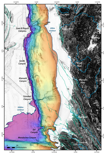
Cascadia is a tectonically active region, and the grand landscape reflects its geologic origins. It is part of the Earth’s famous “Ring of Fire,” created by subduction zone processes as Earth’s tectonic plates collide and move past each other. Volcanoes and earthquakes are characteristic features of subductions zones, and large-scale tectonic movements in subduction zones cause Earth’s largest earthquakes. The displacement and motion associated with these activities also generate tsunamis and landslides that can substantially alter the landscape, threaten human lives, and destroy infrastructure. Much of the evidence of this activity is in the sediments and structures that can be observed through marine geologic mapping in the offshore areas.
The geologic research and mapping in the offshore areas is foundational to understanding how to manage resources and improve public safety in subduction zone areas. The geologic research in the offshore areas is focused along major themes of understanding earthquake recurrence by looking at sedimentary records, looking for evidence of recent seafloor deformation and features that could generate tsunamis, and looking at deep marine seeps and fluids that may support unique ecosystems. The analyses are used to assess earthquake, tsunami, and landslide hazards, evaluate the risks they pose to society, and develop products that enhance situational awareness throughout the Cascadia region.

Related

Cascadia Subduction Zone Marine Geohazards
Related