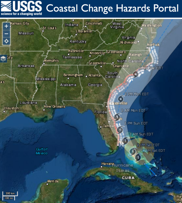
U.S. flag

An official website of the United States government

All Multimedia

Access all multimedia to include images, video, audio, webcams, before-after imagery, and more. Filter and explore with filtering options to refine search. 

Filter Total Items: 24923
Image shows a USGS scientist in safety equipment standing on a bridge measuring floodwaters from Hurricane Isaias
Measuring streamflow on Rock Creek after Hurricane Isaias

Fisseha Mengistu, USGS hydrologic technician, uses a device that lowers a water sampler into the creek below to collect samples used for water quality testing. Experts will be able to use this data to track how Tropical Storm Isaias impacted water quality in the area. This work was done on Rock Creek in Washington, D.C.

Fisseha Mengistu, USGS hydrologic technician, uses a device that lowers a water sampler into the creek below to collect samples used for water quality testing. Experts will be able to use this data to track how Tropical Storm Isaias impacted water quality in the area. This work was done on Rock Creek in Washington, D.C.

Landsat in the Cloud: Will my workflow be supported?

Will my existing workflow still be supported? Landsat downloads will continue to be available via EarthExplorer, LandsatLook, and other familiar USGS tools as they are today, without a noticeable difference to the user. The Landsat record will also remain free and open, with downloads available at no charge to the user.
 

Will my existing workflow still be supported? Landsat downloads will continue to be available via EarthExplorer, LandsatLook, and other familiar USGS tools as they are today, without a noticeable difference to the user. The Landsat record will also remain free and open, with downloads available at no charge to the user.
 

Three researchers in creek sampling with nets surrounded by rocks and mountains
Aquatic insect sampling in Glacier National Park

Researchers taking aquatic insect samples in a high-elevation Glacier National Park stream as part of ecohydrological monitoring efforts to study the effects of climate change on aquatic species and ecosystems. 

Researchers taking aquatic insect samples in a high-elevation Glacier National Park stream as part of ecohydrological monitoring efforts to study the effects of climate change on aquatic species and ecosystems. 

Hurricane Isaias coastal change forecast map 8.1.2020
Hurricane Isaias Unlikely to Cause Widespread Atlantic Beach Erosion

USGS coastal change experts predict that storm waves kicked up by the Category 1 hurricane are likely to cause some erosion at the base of the dunes along about 11 percent of coastal beaches between Florida and Virginia.

This rapid deployment gauge that was installed August 1 in Swansboro, NC to monitor potential flooding caused by Isaias.
RDG installed in NC to monitor potential flooding caused by Isaias

This rapid deployment gauge was installed August 1 in Swansboro, North Carolina on the White Oak River to monitor water levels in order track potential flooding caused by Tropical Storm Isaias. Photo by Bryce McClenney, USGS. 

This rapid deployment gauge was installed August 1 in Swansboro, North Carolina on the White Oak River to monitor water levels in order track potential flooding caused by Tropical Storm Isaias. Photo by Bryce McClenney, USGS. 

Thin section image of a lava sample from Yellowstone using a polarizing microscope.
Thin section image of a lava sample from Yellowstone

Thin section image of a lava sample from Yellowstone using a polarizing microscope. The mineral assemblage is representative of many of Yellowstone’s basaltic rocks. The three large and colored crystals (known as phenocrysts) in the center of the image are the mineral olivine.

Thin section image of a lava sample from Yellowstone using a polarizing microscope. The mineral assemblage is representative of many of Yellowstone’s basaltic rocks. The three large and colored crystals (known as phenocrysts) in the center of the image are the mineral olivine.

 A USGS storm tide sensor is attached to a bridge and will measure the impacts of Hurricane Isaias.
This USGS storm tide sensor installed for Hurricane Isaias.

This USGS storm tide sensor was installed August 1 in North Myrtle Beach, South Carolina to measure the coastal impacts of Hurricane Isaias. Photo by Joshua Lee, USGS.

image related to volcanoes. See description
Timelapse showing typical activity at Kīlauea's summit water lake

This timelapse video at Kīlauea's summit covers approximately 30 minutes and shows the dynamic nature of the water lake in Halema‘uma‘u crater. Steam from the hot water surface is constantly shifting in the winds, while the migrating color boundaries on the water surface appear to show circulation in the lake. USGS video by M. Patrick.

This timelapse video at Kīlauea's summit covers approximately 30 minutes and shows the dynamic nature of the water lake in Halema‘uma‘u crater. Steam from the hot water surface is constantly shifting in the winds, while the migrating color boundaries on the water surface appear to show circulation in the lake. USGS video by M. Patrick.

Man standing in front of a geyser with orange vest on Man standing in front of a geyser with orange vest on
Yellowstone Volcano Observatory Monthly Update: August 1, 2020

Mike Poland, Scientist-in-Charge of the Yellowstone Volcano Observatory, gives an overview of activity at Yellowstone during July 2020.


Timelapse showing typical activity at Kīlauea's summit water lake

This timelapse video at Kīlauea's summit covers approximately 30 minutes and shows the dynamic nature of the water lake in Halema‘uma‘u crater. Steam from the hot water surface is constantly shifting in the winds, while the migrating color boundaries on the water surface appear to show circulation in the lake. USGS video by M. Patrick.

This timelapse video at Kīlauea's summit covers approximately 30 minutes and shows the dynamic nature of the water lake in Halema‘uma‘u crater. Steam from the hot water surface is constantly shifting in the winds, while the migrating color boundaries on the water surface appear to show circulation in the lake. USGS video by M. Patrick.

image related to volcanoes. See description
Kīlauea Volcano's summit water lake is one-year old

Plot showing rise of Kīlauea's summit crater lake over the past year, during which laser rangefinder measurements of lake level were made 2–3 times per week. Photos compare the lake on August 27, 2019, when it was ~22 ft (7 m) deep, to July 7, 2020, when it was ~130 ft (40 m) deep. USGS photos.

Plot showing rise of Kīlauea's summit crater lake over the past year, during which laser rangefinder measurements of lake level were made 2–3 times per week. Photos compare the lake on August 27, 2019, when it was ~22 ft (7 m) deep, to July 7, 2020, when it was ~130 ft (40 m) deep. USGS photos.

Groundwater well casings in Browns Mills study area
Little Pine Lake wells

Groundwater piezometers used to monitor vertical hydraulic gradients, Little Pine Lake, Browns Mills, New Jersey.

Groundwater piezometers used to monitor vertical hydraulic gradients, Little Pine Lake, Browns Mills, New Jersey.

Lake Powell - Topobathymetric Digital Elevation Model

This video is a three-dimensional (3D) view of Lake Powell topobathymetric digital elevation model, which consists of topography (land elevation) and bathymetry (water depth). The 3D topobathymetric model was developed by the U.S.

This video is a three-dimensional (3D) view of Lake Powell topobathymetric digital elevation model, which consists of topography (land elevation) and bathymetry (water depth). The 3D topobathymetric model was developed by the U.S.

image related to volcanoes. See description
Continued slow rise of water in Halema‘uma‘u

Kīlauea's summit water lake, in Halema‘uma‘u, continues to slowly rise. Today, the lake colors were vibrant, with a zone of aquamarine water in the west end (lower right in photo). These greenish zones tend to be slightly hotter, and appear to be zones of water influx. USGS photo by M. Patrick.

Kīlauea's summit water lake, in Halema‘uma‘u, continues to slowly rise. Today, the lake colors were vibrant, with a zone of aquamarine water in the west end (lower right in photo). These greenish zones tend to be slightly hotter, and appear to be zones of water influx. USGS photo by M. Patrick.

Color photo of ecologist Randy Swaty with USGS Eyes on Earth podcast logo
Eyes on Earth - Remapping LANDFIRE
Eyes on Earth Episode 30 – Remapping LANDFIRE
Color photo of ecologist Randy Swaty with USGS Eyes on Earth podcast logo
Eyes on Earth - Remapping LANDFIRE
Eyes on Earth Episode 30 – Remapping LANDFIRE

In the days before LANDFIRE, fire scientists often struggled to find the vegetation and fuels data they needed to map the path of fires, keep firefighters safe, and to model fire recovery.

In the days before LANDFIRE, fire scientists often struggled to find the vegetation and fuels data they needed to map the path of fires, keep firefighters safe, and to model fire recovery.

jezero
Jezero crater, Mars
Jezero crater, Mars
Jezero crater, Mars

This oblique view looking toward the northwest shows the location where a river valley cuts through the rim of Jezero crater and ends in a fan-shaped delta deposit. The Perseverance Mars rover will land near this delta to search for evidence of past life and collect samples that could be returned to Earth by a later mission.

This oblique view looking toward the northwest shows the location where a river valley cuts through the rim of Jezero crater and ends in a fan-shaped delta deposit. The Perseverance Mars rover will land near this delta to search for evidence of past life and collect samples that could be returned to Earth by a later mission.

jezero
Jezero crater, Mars
Jezero crater, Mars
Jezero crater, Mars

Description: This is a high-resolution oblique view of the southern edge of the delta deposit in Jezero crater, the landing site for the Perseverance Mars rover. In the foreground, a butte of delta material stands above the crater floor.

Description: This is a high-resolution oblique view of the southern edge of the delta deposit in Jezero crater, the landing site for the Perseverance Mars rover. In the foreground, a butte of delta material stands above the crater floor.

jezero
Jezero crater, Mars
Jezero crater, Mars
Jezero crater, Mars

Description: This is a high-resolution oblique view of the northeastern edge of the delta deposit in Jezero crater, the landing site for the Perseverance Mars rover. In the foreground, buttes of delta material stand above the crater floor. On the left and in the middle of this image, the layered rocks of the delta deposit are visible.

Description: This is a high-resolution oblique view of the northeastern edge of the delta deposit in Jezero crater, the landing site for the Perseverance Mars rover. In the foreground, buttes of delta material stand above the crater floor. On the left and in the middle of this image, the layered rocks of the delta deposit are visible.

Was this page helpful?