
Steven Fuller making an flood measurement
Images
Explore our planet through photography and imagery, including climate change and water all the way back to the 1800s when the USGS was surveying the country by horse and buggy.
Filter Total Items: 21345

Steven Fuller making an flood measurement

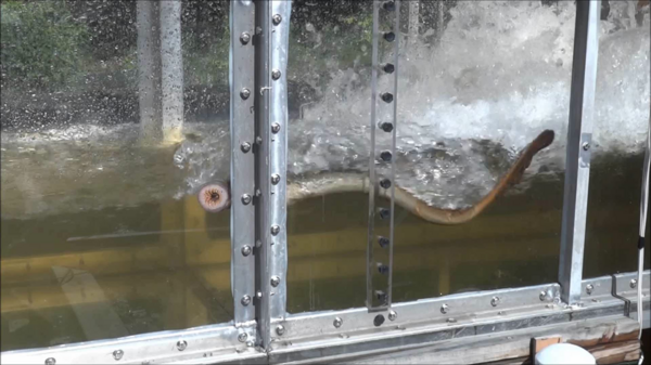
Streamflow Measurements Under Ice Using Acoustic Doppler Technology
Streamflow Measurements Under Ice Using Acoustic Doppler TechnologyHydrologic Technicians from USGS offices across North and South Dakota took part in training on how to make flow measurements under ice using acoustic Doppler technology. This technology increases measurement quality, while decreasing time, effort, and risk to the individuals making the measurements.

Technicians prepare to board a boat to measure water flow.
Technicians prepare to board a boat to measure water flow.USGS technicians prepare to board a boat to go out to the center of the channel in the San Joaquin River below Friant Dam to get an accurate measurement of water flow during releases from the Dam for flood control.

The 3DR Solo with GoPro Hero4 camera and gimbal
The 3DR Solo with GoPro Hero4 camera and gimbal. Coming to a survey area near you soon.
The 3DR Solo with GoPro Hero4 camera and gimbal. Coming to a survey area near you soon.

The USGS conducted surveys on the inner continental shelf of the Delma
The USGS conducted surveys on the inner continental shelf of the DelmaThe USGS conducted surveys on the inner continental shelf of the Delmarva Peninsula (shown in green) to complement related datasets previously collected in the area by partners NOAA and BOEM. The inset map shows location of the study area.

Time series of Grecian Rocks coral reef
Time series of the coral reef at Grecian Rocks (Key Largo, FL) illustrating an example of the dramatic decline in live coral on Florida Keys reefs in recent decades. From Shinn and Kuffner (2017).
Time series of the coral reef at Grecian Rocks (Key Largo, FL) illustrating an example of the dramatic decline in live coral on Florida Keys reefs in recent decades. From Shinn and Kuffner (2017).

Tiny bubbles (of methane)
Methane bubbles emerging from the seafloor at a seep site colonized by chemosynthetic mussels at ~1000 m water depth on the Virginia margin. Photograph taken by the Global Explorer operated by Oceaneering Inc.
Methane bubbles emerging from the seafloor at a seep site colonized by chemosynthetic mussels at ~1000 m water depth on the Virginia margin. Photograph taken by the Global Explorer operated by Oceaneering Inc.

Topographic-change image produced by comparing subsequent 3D maps
Topographic-change image produced by comparing subsequent 3D mapsTopographic-change image produced by comparing 3D map derived from May 27 air photos with that derived from June 13 air photos. Note that material has eroded from the seaward edge of the toe (yellow and orange tones), and material has built up on beaches to either side of the slide (blue tones).

Underwater photo of coral reef, Tutuila Island
Underwater photograph showing corals in Tāfeu Cove, National Park of American Samoa, north shore of Tutuila Island, American Samoa.
Underwater photograph showing corals in Tāfeu Cove, National Park of American Samoa, north shore of Tutuila Island, American Samoa.

Unmanned Aerial System
This small unmanned aerial system with digital camera has been used to create digital elevation models to answer questions about erosion, bridge scour, and other hydraulics analyses.
This small unmanned aerial system with digital camera has been used to create digital elevation models to answer questions about erosion, bridge scour, and other hydraulics analyses.

Unmanned Aerial System in Flight
Small Unmanned Aerial System (UAS) collecting digital photos to create digital elevation models. UAS are an increasingly important tool for monitoring, assessing, and conducting targeted scientific research for the nation.
Small Unmanned Aerial System (UAS) collecting digital photos to create digital elevation models. UAS are an increasingly important tool for monitoring, assessing, and conducting targeted scientific research for the nation.

USGS Groundwater Well
USGS groundwater site 414831072173002 in Tolland County, Connecticut, near the Hydrogeophysics Branch office.
USGS groundwater site 414831072173002 in Tolland County, Connecticut, near the Hydrogeophysics Branch office.

USGS Oceanographer, Neil Ganju, at the 2017 Woods Hole Science Stroll
USGS Oceanographer, Neil Ganju, at the 2017 Woods Hole Science StrollWoods Hole Coastal and Marine Science Center Oceanographer, Neil Ganju, sharing science at the 2017 Woods Hole Science Stroll outreach event
USGS Oceanographer, Neil Ganju, at the 2017 Woods Hole Science Stroll
USGS Oceanographer, Neil Ganju, at the 2017 Woods Hole Science StrollWoods Hole Coastal and Marine Science Center Oceanographer, Neil Ganju, sharing science at the 2017 Woods Hole Science Stroll outreach event

USGS owned Unmanned Aircraft System
Photograph of USGS Kentucky WSC unmanned aircraft system.
Photograph of USGS Kentucky WSC unmanned aircraft system.
USGS research on invasive sea lampreys
USGS scientists perform research on invasive sea lampreys looking for ways to minimize their ability to use fish passages and gain access to new habitats.
USGS scientists perform research on invasive sea lampreys looking for ways to minimize their ability to use fish passages and gain access to new habitats.

USGS scientist collecting samples of aquatic species from Pike River
USGS scientist collecting samples of aquatic species from Pike RiverUSGS scientist collecting samples of aquatic species from the Pike River, Wis., for later analysis of mercury contamination
USGS scientist collecting samples of aquatic species from Pike River
USGS scientist collecting samples of aquatic species from Pike RiverUSGS scientist collecting samples of aquatic species from the Pike River, Wis., for later analysis of mercury contamination
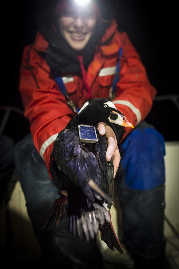
USGS scientist holds a surf scoter that has been tagged.
USGS scientist holds a surf scoter that has been tagged.USGS scientist Sarah Fitzgerald holds a surf scoter that has been fitted with a satellite tag that works by transmitting the location of the birds to satellites that are orbiting the Earth. (Jonathan Fiely, USGS)

USGS scientist measures water, sediment movement in coastal salt marsh
USGS scientist measures water, sediment movement in coastal salt marshUSGS scientist Zafer Defne measures water and sediment movement at Forsythe National Wildlife Refuge, New Jersey. Defne is co-author with Neil Ganju of a 2017 study on how to estimate coastal salt marshes’ potential longevity, based on their sediment budgets and the ratio of open water to vegetation.

USGS Streamgaging on the Pit River operates year round.
USGS Streamgaging on the Pit River operates year round.USGS Streamgaging equipment and cableway on the Pit River near Canby, California operates year round.
USGS Streamgaging on the Pit River operates year round.
USGS Streamgaging on the Pit River operates year round.USGS Streamgaging equipment and cableway on the Pit River near Canby, California operates year round.

USGS Streamgaging Station in northern Nevada.
USGS Streamgaging Station in northern Nevada.
USGS Streamgaging Station in northern Nevada.