
A telephoto view of the northwestern point of the main island within Halema‘uma‘u crater, at Kīlauea summit. A rockfall scar (center left) remains after a small collapse of the island was observed by field geologists around 12:43 p.m. HST on April 20, 2021. A sliver of the active lava lake surface is visible at the bottom of this photo.
Images
Explore our planet through photography and imagery, including climate change and water all the way back to the 1800s when the USGS was surveying the country by horse and buggy.
Filter Total Items: 21344

April 20, 2021 — Kīlauea lava lake and island
A telephoto view of the northwestern point of the main island within Halema‘uma‘u crater, at Kīlauea summit. A rockfall scar (center left) remains after a small collapse of the island was observed by field geologists around 12:43 p.m. HST on April 20, 2021. A sliver of the active lava lake surface is visible at the bottom of this photo.

April 20, 2021 — Kīlauea lava lake and rocks
A telephoto view of the southern lava lake crust and Halema‘uma‘u crater wall at the summit of Kīlauea. Many rockfalls from the steep and unstable crater walls of Halema‘uma‘u have deposited large boulders onto the stagnant lava surface over the past few months. This photo was taken from the west rim of Halema‘uma‘u looking southeast. USGS photo taken by L.
A telephoto view of the southern lava lake crust and Halema‘uma‘u crater wall at the summit of Kīlauea. Many rockfalls from the steep and unstable crater walls of Halema‘uma‘u have deposited large boulders onto the stagnant lava surface over the past few months. This photo was taken from the west rim of Halema‘uma‘u looking southeast. USGS photo taken by L.

April 20, 2021 — Kīlauea vent
A telephoto view of the west vent and lava lake inlet within Halema‘uma‘u crater at the summit of Kīlauea. Lava erupting from the west vent (upper left) continues to feed into the active lava lake through a wide inlet near the base of the cone (center right).
A telephoto view of the west vent and lava lake inlet within Halema‘uma‘u crater at the summit of Kīlauea. Lava erupting from the west vent (upper left) continues to feed into the active lava lake through a wide inlet near the base of the cone (center right).

April 21 - Halema‘uma‘u crater
A view of Halema‘uma‘u crater at the summit of Kīlauea Volcano, Island of Hawai‘i, showing the active western fissure with rising fumes, the active western portion of the lava lake (lighter colored area in the middle of the photo), and the big island within the lava lake (right).
A view of Halema‘uma‘u crater at the summit of Kīlauea Volcano, Island of Hawai‘i, showing the active western fissure with rising fumes, the active western portion of the lava lake (lighter colored area in the middle of the photo), and the big island within the lava lake (right).
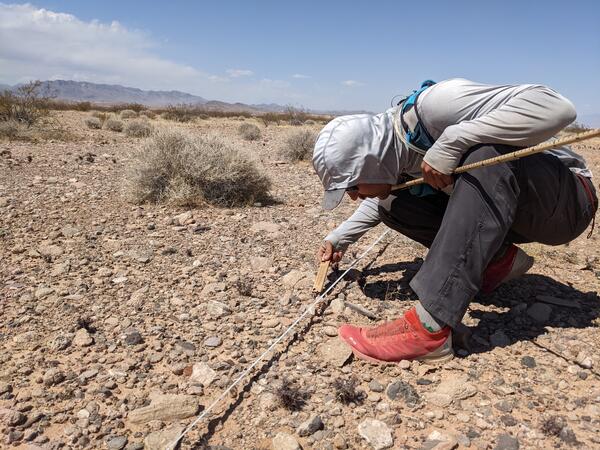
Pre-construction monitoring of vegetation for the Gemini Solar Array
Pre-construction monitoring of vegetation for the Gemini Solar ArrayThe United States is developing renewable energy resources, especially solar, at a rapid rate.
Pre-construction monitoring of vegetation for the Gemini Solar Array
Pre-construction monitoring of vegetation for the Gemini Solar ArrayThe United States is developing renewable energy resources, especially solar, at a rapid rate.
Kīlauea summit eruption four-month anniversary
April 20 was the four-month anniversary of Kīlauea's ongoing summit eruption in Halema‘uma‘u. This animated GIF features approximately one thermal image for each day of the eruption and demonstrates eruptive activity over the past four months. At 9:30 p.m.
April 20 was the four-month anniversary of Kīlauea's ongoing summit eruption in Halema‘uma‘u. This animated GIF features approximately one thermal image for each day of the eruption and demonstrates eruptive activity over the past four months. At 9:30 p.m.

Laser Flow in Storm Drain at Hampton Coliseum
The Region 1, April 2021 "Honorable Mention #1" Winner (by Chelsea Delsack)
The Region 1, April 2021 "Honorable Mention #1" Winner (by Chelsea Delsack)

Photographs from a wild turkey found dead in Minnesota
Photographs from a wild turkey found dead in MinnesotaPhotographs from a wild turkey (Meleagris gallopavo) found dead in Minnesota, USA. (A) There are numerous multifocal to coalescing yellow proliferative lesions covering the eyelids, head, and neck with a region of ulceration and necrosis (*). (B) Yellow irregular plaques (arrow heads) multifocally cover the oral cavity.

Photomicrographs from a wild turkey found dead in Minnesota
Photomicrographs from a wild turkey found dead in MinnesotaPhotomicrographs from a wild turkey (Meleagris gallopavo) found dead in Minnesota, USA. (A) The normal epithelium becomes markedly thickened due to hyperplasia of the stratum spinosum (left to right) with regions of ulceration and crusting (arrow). H&E stain.

Deciduous trees in Reston, Virginia
Decidous trees in Reston, Virginia. Photo taken for Arbor Day 2021 near USGS Headquarters.
Decidous trees in Reston, Virginia. Photo taken for Arbor Day 2021 near USGS Headquarters.

April 16, 2021: Overview of Halema‘uma‘u lava lake western portion
April 16, 2021: Overview of Halema‘uma‘u lava lake western portionDuring a Kīlauea summit helicopter overflight on Friday, April 16, an HVO scientist captured this photo of the erupting western fissure and surrounding lava lake within Halema‘uma‘u. The active western potion of the lava lake, as seen here, measured approximately 300 m (984 ft) from end-to-end at the time. USGS image.

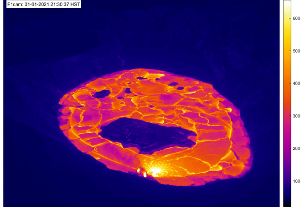
April 19, 2021—Kīlauea summit eruption thermal map
April 19, 2021—Kīlauea summit eruption thermal mapA helicopter overflight on April 16, 2021, at approximately 12 p.m. HST allowed for aerial visual and thermal imagery to be collected of the eruption within Halema‘uma‘u crater at the summit of Kīlauea Volcano.

Halema‘uma‘u lava lake, Kīlauea summit eruption—April 16, 2021
Halema‘uma‘u lava lake, Kīlauea summit eruption—April 16, 2021A view of the lava lake from the east rim of Halema‘uma‘u Crater, at the summit of Kīlauea. The active portion of the lake is present at the far (western) end of the crater. USGS photo by M. Patrick on April 16, 2021.

Halema‘uma‘u lava lake, Kīlauea summit eruption—April 16, 2021
Halema‘uma‘u lava lake, Kīlauea summit eruption—April 16, 2021A view of the south margin of the perched lava lake in Halema‘uma‘u Crater, at the summit of Kīlauea. This photo was taken from the east rim of the crater, and shows the steep levee containing the lake. USGS photo by M. Patrick.

Halema‘uma‘u, Kīlauea summit—April 16, 2021
An HVO geologist surveys the lava lake from the eastern rim of Halema‘uma‘u Crater, at the summit of Kīlauea. The cliff that covers most of the top half of the photo formed during the collapse events of 2018, and gives a sense of the scale of that event. USGS photo by M. Patrick on April 16, 2021.
An HVO geologist surveys the lava lake from the eastern rim of Halema‘uma‘u Crater, at the summit of Kīlauea. The cliff that covers most of the top half of the photo formed during the collapse events of 2018, and gives a sense of the scale of that event. USGS photo by M. Patrick on April 16, 2021.

Halema‘uma‘u eruptive activity — April 14, 2021
A close-up view of the western fissure within Halema‘uma‘u at the summit of Kīlauea Volcano, Island of Hawai‘i. Lava continues to enter the lava lake from a wide inlet near the base of the western vent (fuming at center right). Crustal foundering is common on the active lava lake surface (center bottom), located on the western side of the crater.
A close-up view of the western fissure within Halema‘uma‘u at the summit of Kīlauea Volcano, Island of Hawai‘i. Lava continues to enter the lava lake from a wide inlet near the base of the western vent (fuming at center right). Crustal foundering is common on the active lava lake surface (center bottom), located on the western side of the crater.

Mousam River at West Kennebunk, Maine
Hydrologic Technician Andy Cloutier visited USGS gaging station 01069500 on the Mousam River at West Kennebunk, Maine in mid-April of 2021.
Hydrologic Technician Andy Cloutier visited USGS gaging station 01069500 on the Mousam River at West Kennebunk, Maine in mid-April of 2021.

Sunset at Colvin Creek - Reston, Virginia
A photograph of Colvin Creek during a cool Fall reddish sunset in Reston, Virginia
A photograph of Colvin Creek during a cool Fall reddish sunset in Reston, Virginia

Halema‘uma‘u lava lake, Kīlauea summit eruption—April 13, 2021
Halema‘uma‘u lava lake, Kīlauea summit eruption—April 13, 2021This view from the south rim of Halema‘uma‘u shows the perched lava lake, supplied by lava from the western fissure (upper right portion of photo). The levee surrounding the active lava lake is up to about 5 m (16 ft) high. USGS photo by M. Patrick on April 13, 2021.

Halema‘uma‘u lava lake, Kīlauea summit eruption—April 13, 2021
Halema‘uma‘u lava lake, Kīlauea summit eruption—April 13, 2021A close up view of the inlet at the western margin of the lava lake in Halema‘uma‘u Crater, at the summit of Kīlauea. The lava stream was covered in a thin, flexible crust and was moving at a very slow velocity. USGS photo taken by M. Patrick on April 13, 2021.

Scientist installing a nest box near Ashumet Pond, Cape Cod, Mass.
Scientist installing a nest box near Ashumet Pond, Cape Cod, Mass.Scientist istalling a swallow nest box near Ashumet Pond, Cape Cod Massachusetts as part of a study on the fate and effects of PFAS chemicals.
Scientist installing a nest box near Ashumet Pond, Cape Cod, Mass.
Scientist installing a nest box near Ashumet Pond, Cape Cod, Mass.Scientist istalling a swallow nest box near Ashumet Pond, Cape Cod Massachusetts as part of a study on the fate and effects of PFAS chemicals.