
This long thin, strand of volcanic glass is called Pele's hair. Named for Pele, the Hawaiian goddess of fire, Pele's hair is formed from lava fountains and rapidly moving lava flows. This strand of Pele’s hair was found on Kupono Street in Leilani Estates, Hawaii, during the Kīlauea volcano eruption.
Images
Explore our planet through photography and imagery, including climate change and water all the way back to the 1800s when the USGS was surveying the country by horse and buggy.
Filter Total Items: 21343

Pele's Hair
This long thin, strand of volcanic glass is called Pele's hair. Named for Pele, the Hawaiian goddess of fire, Pele's hair is formed from lava fountains and rapidly moving lava flows. This strand of Pele’s hair was found on Kupono Street in Leilani Estates, Hawaii, during the Kīlauea volcano eruption.

Kīlauea LERZ Fissures and Flows, May 30, 3:00 p.m.
Kīlauea LERZ Fissures and Flows, May 30, 3:00 p.m.Map as of 3:00 p.m. HST, May 30, 2018. Given the dynamic nature of Kīlauea's lower East Rift Zone eruption, with changing vent locations, fissures starting and stopping, and varying rates of lava effusion, map details shown here are accurate as of the date/time noted. Shaded purple areas indicate lava flows erupted in 1840, 1955, 1960, and 2014-2015.

Kīlauea LERZ Fissures and Flows, May 30, 9:00 a.m.
Kīlauea LERZ Fissures and Flows, May 30, 9:00 a.m.Map as of 9:00 a.m. HST, May 30, 2018. Given the dynamic nature of Kīlauea's lower East Rift Zone eruption, with changing vent locations, fissures starting and stopping, and varying rates of lava effusion, map details shown here are accurate as of the date/time noted—and could have changed rapidly since that time.

Kīlauea summit activity
Views Kīlauea's summit were often obscured by fog and rain today, but a break in the weather around 2:00 p.m. HST allowed HVO's webcam to capture this image of the gas and steam plume being emitted from Halema‘uma‘u.
Views Kīlauea's summit were often obscured by fog and rain today, but a break in the weather around 2:00 p.m. HST allowed HVO's webcam to capture this image of the gas and steam plume being emitted from Halema‘uma‘u.

Kīlauea Volcano —

Kīlauea Volcano — Summit Plume
Views Kīlauea's summit were often obscured by fog and rain today, but a break in the weather around 2:00 p.m. HST allowed HVO's webcam to capture this image of the gas and steam plume being emitted from Halema‘uma‘u.
Views Kīlauea's summit were often obscured by fog and rain today, but a break in the weather around 2:00 p.m. HST allowed HVO's webcam to capture this image of the gas and steam plume being emitted from Halema‘uma‘u.

USGS Scientist Chuck Henny Holds Osprey
USGS scientist Chuck Henny holds osprey

USGS scientist using an Unmanned Aerial Vehicle (UAV)
USGS scientist using an Unmanned Aerial Vehicle (UAV)USGS scientist Todd Preston using an Unmanned Aerial Vehicle (UAV). USGS is actively exploring the use of small unmanned aerial system (aka drones) for scientific data collection and testing whether or not they are useful in monitoring wildlife.

Weather station in sagebrush steppe
A weather station located in a sagebrush ecosystem in southwest Montana—a major ecosystem type managed by the Bureau of Land Management
A weather station located in a sagebrush ecosystem in southwest Montana—a major ecosystem type managed by the Bureau of Land Management

Well CH 10, groundwater quality monitoring network, Chester County, PA
Well CH 10, groundwater quality monitoring network, Chester County, PAWell CH 10 is part of a Pennsylvania groundwater quality monitoring network and is in Chester County, Pennsylvania.
Well CH 10, groundwater quality monitoring network, Chester County, PA
Well CH 10, groundwater quality monitoring network, Chester County, PAWell CH 10 is part of a Pennsylvania groundwater quality monitoring network and is in Chester County, Pennsylvania.

Zebra Mussels St. Lawrence River
During a National Water Quality Network (NWQN) sampling trip in May to the St Lawrence River, Hydrologic Technician Dave Knauer finds a batch of Zebra mussels attached to the boat anchor.
During a National Water Quality Network (NWQN) sampling trip in May to the St Lawrence River, Hydrologic Technician Dave Knauer finds a batch of Zebra mussels attached to the boat anchor.

Kīlauea LERZ Fissures and Flows, May 29, 6:00 p.m.
Kīlauea LERZ Fissures and Flows, May 29, 6:00 p.m.Map as of 6:00 p.m. HST, May 29, 2018. Given the dynamic nature of Kīlauea's lower East Rift Zone eruption, with changing vent locations, fissures starting and stopping, and varying rates of lava effusion, map details shown here are accurate as of the date/time noted—and could have changed rapidly since that time.

Kīlauea Volcano —
Fissure 8 reactivated on the afternoon of May 28, when, at times, lava fountains were reaching heights of 200 feet and feeding a lava flow&
Fissure 8 reactivated on the afternoon of May 28, when, at times, lava fountains were reaching heights of 200 feet and feeding a lava flow&
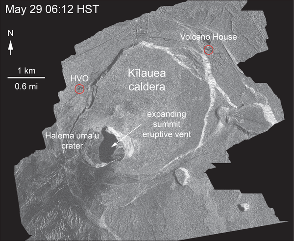
Kīlauea Volcano — Animation of Summit Enlargement
This animated GIF shows a sequence of radar amplitude images that were acquired by the Italian Space Agency's Cosmo-SkyMed satellite system. The series shows changes to the caldera area of Kīlauea Volcano that occurred over May 5 at 6:12 a.m. HST, May 17 at 6:12 a.m.
This animated GIF shows a sequence of radar amplitude images that were acquired by the Italian Space Agency's Cosmo-SkyMed satellite system. The series shows changes to the caldera area of Kīlauea Volcano that occurred over May 5 at 6:12 a.m. HST, May 17 at 6:12 a.m.

Kīlauea Volcano — Tephra on Leilani Street
Tephra (airborne lava fragments) erupted by the high lava fountains of fissure 8 was carried downwind, where the frothy rock fragments fell on Leilani Street, just past Kupono Street, in the Leilani Estates subdivision.
Tephra (airborne lava fragments) erupted by the high lava fountains of fissure 8 was carried downwind, where the frothy rock fragments fell on Leilani Street, just past Kupono Street, in the Leilani Estates subdivision.

Kīlauea Volcano — Weak Ocean Entry
Scientists on the early morning overflight of Kīlauea Volcano's lower East Rift Zone documented a very weak ocean entry. For the easternmost lobe, only a few small finger channels of lava were entering the ocean.
Scientists on the early morning overflight of Kīlauea Volcano's lower East Rift Zone documented a very weak ocean entry. For the easternmost lobe, only a few small finger channels of lava were entering the ocean.

Overflight confirms weak ocean entry, in Kīlauea's LERZ
Overflight confirms weak ocean entry, in Kīlauea's LERZScientists on the early morning overflight of Kīlauea Volcano's lower East Rift Zone documented a very weak ocean entry. For the easternmost lobe, only a few small finger channels of lava were entering the ocean.

Kilauea Volcano — Ocean Entry Aerial
Close view of weak ocean entry at about 1:05 p.m. HST. Only small and intermittent "laze" plumes have been observed today.
Close view of weak ocean entry at about 1:05 p.m. HST. Only small and intermittent "laze" plumes have been observed today.

Kilauea Volcano — Pohoiki Road Lava Flow
View of the now-sluggish lava flow that crossed Pohoiki Road earlier today; the flow originated from fissure 8. This fissure was very active overnight, slowed this morning, and stopped by about noon.
View of the now-sluggish lava flow that crossed Pohoiki Road earlier today; the flow originated from fissure 8. This fissure was very active overnight, slowed this morning, and stopped by about noon.

Kīlauea LERZ Fissures and Flows, May 28, 3:00 p.m.
Kīlauea LERZ Fissures and Flows, May 28, 3:00 p.m.Map as of 3:00 p.m. HST, May 28, 2018. Shaded purple areas indicate lava flows erupted in 1840, 1955, 1960, and 2014-2015.
Kīlauea LERZ Fissures and Flows, May 28, 3:00 p.m.
Kīlauea LERZ Fissures and Flows, May 28, 3:00 p.m.Map as of 3:00 p.m. HST, May 28, 2018. Shaded purple areas indicate lava flows erupted in 1840, 1955, 1960, and 2014-2015.

Kīlauea Volcano — Fissure Complex
View of the fissure complex looking toward the southwest (uprift) during this afternoon's overflight at about 1:15 p.m. HST. The small lava flows spreading to the southeast from the fissure complex (lower middle) originate in the area of between fissures 16 and 18.
View of the fissure complex looking toward the southwest (uprift) during this afternoon's overflight at about 1:15 p.m. HST. The small lava flows spreading to the southeast from the fissure complex (lower middle) originate in the area of between fissures 16 and 18.