
The median between two areas of the parking lot has been warped and broken by cracks. Ash accumulation in the parking area was generally not more than 4 cm (1.5 in) thick.
Images
Explore our planet through photography and imagery, including climate change and water all the way back to the 1800s when the USGS was surveying the country by horse and buggy.
Filter Total Items: 21343

Kīlauea Volcano — Crack in Parking Lot
The median between two areas of the parking lot has been warped and broken by cracks. Ash accumulation in the parking area was generally not more than 4 cm (1.5 in) thick.

Kīlauea Volcano — Crack on Crater Rim Drive
Crack on Crater Rim Drive just east of the parking lot, with the National Park sign indicating "Halema‘uma‘u" at right. This crack shows 42 cm (16.5 in) of right lateral offset—as measured by fitting the center stripe on the road back together)—and was about 25 cm (10 in) wide.
Crack on Crater Rim Drive just east of the parking lot, with the National Park sign indicating "Halema‘uma‘u" at right. This crack shows 42 cm (16.5 in) of right lateral offset—as measured by fitting the center stripe on the road back together)—and was about 25 cm (10 in) wide.

Kīlauea Volcano — Halema`uma`u Parking Lot
The Halema‘uma‘u parking lot is sliced into blocks by cracks. These cracks, first noted in a very early stage on May 13, now are the dominant features of the parking lot. The cracks, which are circumferential to Halema‘uma‘u, warp and offset the pavement and curbing, as seen here. The crack responsible for warping this curbstone is visible on both sides of it.
The Halema‘uma‘u parking lot is sliced into blocks by cracks. These cracks, first noted in a very early stage on May 13, now are the dominant features of the parking lot. The cracks, which are circumferential to Halema‘uma‘u, warp and offset the pavement and curbing, as seen here. The crack responsible for warping this curbstone is visible on both sides of it.

Kīlauea Volcano — Large Crack in Parking Lot
An even larger crack, shown here, arcs across the parking lot and bounds one of the large blocks mentioned above.
An even larger crack, shown here, arcs across the parking lot and bounds one of the large blocks mentioned above.

Kīlauea Volcano — Large Rocks on Parking Lot
Many large blocks appeared to be in depressions in the ash, but upon closer examination, it was concluded that wind had winnowed ash from around the blocks, creating a false impression that the depressions were made by impact.
Many large blocks appeared to be in depressions in the ash, but upon closer examination, it was concluded that wind had winnowed ash from around the blocks, creating a false impression that the depressions were made by impact.

Kīlauea Volcano — Lava Fountain (Fissure 8)
Fissure 8 lava fountain heights fluctuated between about 40 m (130 ft) and 70 m (230 ft) during this morning's overflight at about 6:30 a.m. HST.
Fissure 8 lava fountain heights fluctuated between about 40 m (130 ft) and 70 m (230 ft) during this morning's overflight at about 6:30 a.m. HST.

Kīlauea Volcano — Lava Fountain and Flow (Fissure 8)
Kīlauea Volcano — Lava Fountain and Flow (Fissure 8)View of the fissure 8 lava fountain and lava channel that travels to the ocean, a distance of about 12.5 km (7.8 mi). Photo taken during this morning's overflight at about 6:30 a.m. HST.
Kīlauea Volcano — Lava Fountain and Flow (Fissure 8)
Kīlauea Volcano — Lava Fountain and Flow (Fissure 8)View of the fissure 8 lava fountain and lava channel that travels to the ocean, a distance of about 12.5 km (7.8 mi). Photo taken during this morning's overflight at about 6:30 a.m. HST.

Kīlauea Volcano — Laze Plume
Lava enters the ocean in the vicinity of Vacationland at 7 a.m. HST. The ocean entry produces a white plume called "laze," which drifts downwind. Laze is composed of steam, hydrochloric acid and tiny volcanic glass particles, which can irritate the lungs, eyes and skin.
Lava enters the ocean in the vicinity of Vacationland at 7 a.m. HST. The ocean entry produces a white plume called "laze," which drifts downwind. Laze is composed of steam, hydrochloric acid and tiny volcanic glass particles, which can irritate the lungs, eyes and skin.

Kīlauea Volcano — Ocean Entry Near Vacationland
Lava entering the ocean in the vicinity of Kapoho Bay is forming a lava delta, as seen from the air during this morning's overflight at about 7:00 a.m. HST.
Lava entering the ocean in the vicinity of Kapoho Bay is forming a lava delta, as seen from the air during this morning's overflight at about 7:00 a.m. HST.
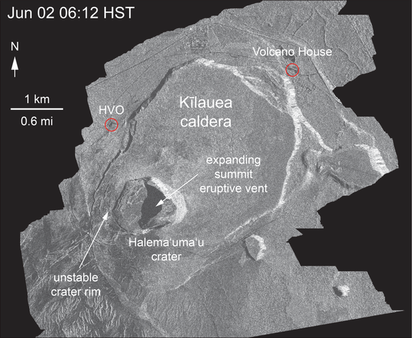
Kīlauea Volcano — Satellite Radar of Crater Slumping
Kīlauea Volcano — Satellite Radar of Crater SlumpingThis animated GIF shows a sequence of radar amplitude images that were acquired by the Italian Space Agency's Cosmo-SkyMed satellite system. The images illustrate changes to the caldera area of Kīlauea Volcano that occurred between May 5 and June 6 at 6:00 a.m. HST.

Nearshore geophysical mapping
Nearshore geophysical mapping with sub-bottom sled (foreground), personal watercraft equipped with echosounders (background, water) and beach-based personnel (background, beach).
Nearshore geophysical mapping with sub-bottom sled (foreground), personal watercraft equipped with echosounders (background, water) and beach-based personnel (background, beach).

Kīlauea LERZ lava flows and fissures, June 6, 12:00 p.m.
Kīlauea LERZ lava flows and fissures, June 6, 12:00 p.m.Map as of 12:00 p.m. (noon) HST, June 6, 2018. Given the dynamic nature of Kīlauea's lower East Rift Zone eruption, with changing vent locations, fissures starting and stopping, and varying rates of lava effusion, map details shown here are accurate as of the date/time noted. Shaded purple areas indicate lava flows erupted in 1840, 1955, 1960, and 2014-2015.

Kīlauea Volcano — Halema`uma`u Explosion (June 6)

Kīlauea Volcano — Kapoho Beach Lots
Views from HVO's helicopter overflight at 1PM HST, show the remains of the Kapoho Beach Lots subdivision and the fissure 8 flow front. The northern flow margin in this area was unchanged from HVO's morning flight and appeared to have stopped advancing at the time of the flight.
Views from HVO's helicopter overflight at 1PM HST, show the remains of the Kapoho Beach Lots subdivision and the fissure 8 flow front. The northern flow margin in this area was unchanged from HVO's morning flight and appeared to have stopped advancing at the time of the flight.

Kīlauea Volcano — Lava Delta at Kapoho Bay
This fish-eye view of the lava delta filling the former Kapoho Bay shows that while the delta margin nearest the ocean has cooled somewhat, the lava flow front is still very hot and producing laze (lava haze). Laze is a local hazard composed of acidic gases and volcanic glass fragments and should be avoided.
This fish-eye view of the lava delta filling the former Kapoho Bay shows that while the delta margin nearest the ocean has cooled somewhat, the lava flow front is still very hot and producing laze (lava haze). Laze is a local hazard composed of acidic gases and volcanic glass fragments and should be avoided.

Kīlauea Volcano — Lava Fountaining (Fissure 8)
The vigorous lava fountain at Fissure 8 reached heights of 45 m (150 ft) as shown in this image taken around 9:30 AM.
The vigorous lava fountain at Fissure 8 reached heights of 45 m (150 ft) as shown in this image taken around 9:30 AM.


Kīlauea Volcano — Lower East Rift Zone
This view, looking south at Kīlauea's lower East Rift Zone, was captured during HVO's 6:00 a.m. HST helicopter overflight today.
This view, looking south at Kīlauea's lower East Rift Zone, was captured during HVO's 6:00 a.m. HST helicopter overflight today.

Kīlauea Volcano — Satellite Imagery Fissure 8
The International Charter for Space and Major Disasters (https://disasterscharter.org/) is a means for space agencies around the world to help with disaster monitoring by providing satellite data to responders and scientists on the ground.
The International Charter for Space and Major Disasters (https://disasterscharter.org/) is a means for space agencies around the world to help with disaster monitoring by providing satellite data to responders and scientists on the ground.

lava is rapidly advancing through communities
How do you keep people safe when lava is rapidly advancing through communities? This was just one of the topics addressed during the Cities on Volcanoes 10 meeting in Naples, Italy, last week. Lava flows recently erupted from Kīlauea Volcano's lower East Rift Zone inundated hundreds of homes in the lower Puna District of Hawai‘i Island.
How do you keep people safe when lava is rapidly advancing through communities? This was just one of the topics addressed during the Cities on Volcanoes 10 meeting in Naples, Italy, last week. Lava flows recently erupted from Kīlauea Volcano's lower East Rift Zone inundated hundreds of homes in the lower Puna District of Hawai‘i Island.

SEM Laboratory
Scientists look at a pollen palynomorph using a scanning electron microscope (SEM).
Scientists look at a pollen palynomorph using a scanning electron microscope (SEM).