USGS scientist preparing plates for yeast bioassay screening
USGS scientist preparing plates for yeast bioassay screeningUSGS scientists working at laboratory fume hood

Official websites use .gov
A .gov website belongs to an official government organization in the United States.
Secure .gov websites use HTTPS
A lock () or https:// means you’ve safely connected to the .gov website. Share sensitive information only on official, secure websites.
Explore our planet through photography and imagery, including climate change and water all the way back to the 1800s when the USGS was surveying the country by horse and buggy.

USGS scientists working at laboratory fume hood
USGS scientists working at laboratory fume hood
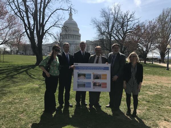
On April 12, the USGS, together with the American Fisheries Society (AFS), hosted a roundtable discussion with congressional staff centered on the impacts of extreme weather events like hurricanes, floods, droughts, and wildfires on inland fish. Scientists with the USGS National Climate Adaptation Science Center (NCASC) are investigating how climate-relate
On April 12, the USGS, together with the American Fisheries Society (AFS), hosted a roundtable discussion with congressional staff centered on the impacts of extreme weather events like hurricanes, floods, droughts, and wildfires on inland fish. Scientists with the USGS National Climate Adaptation Science Center (NCASC) are investigating how climate-relate

Dead Run is an urban creek in Catonsville, Maryland, near Baltimore. Research has found that about half of the bed sediment originates as particulate matter on pavement that then is washed into the creek via storm drains.
Dead Run is an urban creek in Catonsville, Maryland, near Baltimore. Research has found that about half of the bed sediment originates as particulate matter on pavement that then is washed into the creek via storm drains.

Dead Run is an urban creek in Catonsville, Maryland, near Baltimore. Research has found that about half of the bed sediment originates as particulate matter on pavement that then is washed into the creek via storm drains.
Dead Run is an urban creek in Catonsville, Maryland, near Baltimore. Research has found that about half of the bed sediment originates as particulate matter on pavement that then is washed into the creek via storm drains.

Dead Run is an urban creek in Catonsville, Maryland, near Baltimore. Research has found that about half of the bed sediment originates as particulate matter on pavement that then is washed into the creek via storm drains.
Dead Run is an urban creek in Catonsville, Maryland, near Baltimore. Research has found that about half of the bed sediment originates as particulate matter on pavement that then is washed into the creek via storm drains.

Dead Run is an urban creek in Catonsville, Maryland, near Baltimore. Research has found that about half of the bed sediment originates as particulate matter on pavement that then is washed into the creek via storm drains.
Dead Run is an urban creek in Catonsville, Maryland, near Baltimore. Research has found that about half of the bed sediment originates as particulate matter on pavement that then is washed into the creek via storm drains.

Dead Run is an urban creek in Catonsville, Maryland, near Baltimore. Research has found that about half of the bed sediment originates as particulate matter on pavement that then is washed into the creek via storm drains.
Dead Run is an urban creek in Catonsville, Maryland, near Baltimore. Research has found that about half of the bed sediment originates as particulate matter on pavement that then is washed into the creek via storm drains.

Groundwater - Surveying - Global Navigation Satellite System (GNSS) Suffolk County, Long Island, NY
Groundwater - Surveying - Global Navigation Satellite System (GNSS) Suffolk County, Long Island, NY

The 3DR Solo quadcopter in flight, with a Ricoh GRII camera mounted, taking pictures to be used in photogrammetric techniques to produce 3D surface models.
The 3DR Solo quadcopter in flight, with a Ricoh GRII camera mounted, taking pictures to be used in photogrammetric techniques to produce 3D surface models.

Fish on the lake-bottom at South Manitou Island Lake Micigan
Fish on the lake-bottom at South Manitou Island Lake Micigan

Fish on the lake-bottom at South Manitou Island Lake Micigan
Fish on the lake-bottom at South Manitou Island Lake Micigan

Black River at Elyria, OH - high water

Black River at Elyria, OH - view from bank , fast moving water
Black River at Elyria, OH - view from bank , fast moving water

Most of the lava flow (dark black) produced by the April 1868 Mauna Loa eruption can be seen in this aerial photo on the west (left) side of the prominent fault scarp, known informally as the Kahuku pali (formal names are Pali o Mamalu for the upper half and Pali‘okūlani for the lower half of the scarp).
Most of the lava flow (dark black) produced by the April 1868 Mauna Loa eruption can be seen in this aerial photo on the west (left) side of the prominent fault scarp, known informally as the Kahuku pali (formal names are Pali o Mamalu for the upper half and Pali‘okūlani for the lower half of the scarp).

Organic Chemistry Research Laboratory — Sacramento, California. Gas chromatograph-mass spectrometer - GCMS
Organic Chemistry Research Laboratory — Sacramento, California. Gas chromatograph-mass spectrometer - GCMS

USGS scientist examining human breast cancer cells under a microscope in the cell bioassay laboratory at Columbia Environmental Research Center. Behind the scientist is an automated liquid handling system for dispensing reagents into multi-well micropates for bioassay experiments.
USGS scientist examining human breast cancer cells under a microscope in the cell bioassay laboratory at Columbia Environmental Research Center. Behind the scientist is an automated liquid handling system for dispensing reagents into multi-well micropates for bioassay experiments.

Video: Clear skies and sunshine provided a spectacular view of Kīlauea Volcano's summit lava lake this morning. Spattering on the north side and center of the lake surface—a departure from its more common location on the southeast side of the lake—occasionally happens when the surface flow direction reverses.
Video: Clear skies and sunshine provided a spectacular view of Kīlauea Volcano's summit lava lake this morning. Spattering on the north side and center of the lake surface—a departure from its more common location on the southeast side of the lake—occasionally happens when the surface flow direction reverses.

Bioactive Chemicals Research Laboratory -- Boulder, Colorado. Fathead minnows (Pimephales promelas) swimming in an expermental aquaium
Bioactive Chemicals Research Laboratory -- Boulder, Colorado. Fathead minnows (Pimephales promelas) swimming in an expermental aquaium

USGS scientists setting up the nuclear magnetic resonance (NMR) geophyiscal logging cable to collect information about rock properties from a groundwater well borehole in the Texas southern highplains.
USGS scientists setting up the nuclear magnetic resonance (NMR) geophyiscal logging cable to collect information about rock properties from a groundwater well borehole in the Texas southern highplains.

Fathead minnows (Pimephales promelas) swimming in an expermental aquaium. The aquarium is part of an experiment to assess endocrine disruption in fish.
Fathead minnows (Pimephales promelas) swimming in an expermental aquaium. The aquarium is part of an experiment to assess endocrine disruption in fish.

Marshmallow-like formations were photographed on the Cannonball River at Regent, North Dakota (USGS streamgage 06350000) on April 3, 2018. Foam is produced naturally from organic material in the water in combination with turbulence resulting from water flowing over the weir.
Marshmallow-like formations were photographed on the Cannonball River at Regent, North Dakota (USGS streamgage 06350000) on April 3, 2018. Foam is produced naturally from organic material in the water in combination with turbulence resulting from water flowing over the weir.