



From left to right, USGS scientists Sam McGill, Lucas WinklerPrins, David Hart, Selina Davila Olivera, and Pete Dal Ferro work on Grizzly Bay on the vessel Jewell, to collect sediment samples using the GOMEX box corer.
Images
Explore our planet through photography and imagery, including climate change and water all the way back to the 1800s when the USGS was surveying the country by horse and buggy.
Filter Total Items: 21394

Preparing the GOMEX on Grizzly Bay
From left to right, USGS scientists Sam McGill, Lucas WinklerPrins, David Hart, Selina Davila Olivera, and Pete Dal Ferro work on Grizzly Bay on the vessel Jewell, to collect sediment samples using the GOMEX box corer.

Sampling on Grizzly Bay
On PCMSC vessel Jewell, a team of USGS scientists sit in Grizzly Bay, a baylet of San Francisco Bay in Solano County, California. USGS collects sediment samples to study how sediment moves through sensitive coastal environments like this.
On PCMSC vessel Jewell, a team of USGS scientists sit in Grizzly Bay, a baylet of San Francisco Bay in Solano County, California. USGS collects sediment samples to study how sediment moves through sensitive coastal environments like this.

Sediment collected in a GOMEX box corer
USGS science crew works to free the muddy sediment from a GOMEX box corer. They are on board the Pacific Coastal and Marine Science Center's vessel Jewell on Grizzly Bay in the San Francisco Bay area.
USGS science crew works to free the muddy sediment from a GOMEX box corer. They are on board the Pacific Coastal and Marine Science Center's vessel Jewell on Grizzly Bay in the San Francisco Bay area.

Weather station power supply and modem
A weather station, installed in the middle of Grizzly Bay east of San Pablo Bay (near San Francisco), gets its power from a small solar panel. Data collected from the station is transmitted via a wireless modem. Far in the background is the city of Benicia, and the plume rising into the sky is water vapor emitted from the Benicia oil refinery.
A weather station, installed in the middle of Grizzly Bay east of San Pablo Bay (near San Francisco), gets its power from a small solar panel. Data collected from the station is transmitted via a wireless modem. Far in the background is the city of Benicia, and the plume rising into the sky is water vapor emitted from the Benicia oil refinery.

Yellowstone Wildlife
Wildlife out in force in Yellowstone as streamgagers headed into streamgages on Firehole and Gibbon Rivers. The thermal activity of the area means that the Firehole River is almost always ice free.
Wildlife out in force in Yellowstone as streamgagers headed into streamgages on Firehole and Gibbon Rivers. The thermal activity of the area means that the Firehole River is almost always ice free.

Yellowstone Wildlife
Wildlife out in force in Yellowstone as streamgagers headed into streamgages on Firehole and Gibbon Rivers. The thermal activity of the area means that the Firehole River is almost always ice free.
Wildlife out in force in Yellowstone as streamgagers headed into streamgages on Firehole and Gibbon Rivers. The thermal activity of the area means that the Firehole River is almost always ice free.

Semipalmated Sandpipers with leg bands or leg bands plus flag
Semipalmated Sandpipers with leg bands or leg bands plus flagSemipalmated Sandpipers with A) Leg bands only (no flag), or B) leg bands plus flag From: Leg flags do not affect shorebird nests: https://doi.org/10.1111/jofo.12264
Semipalmated Sandpipers with leg bands or leg bands plus flag
Semipalmated Sandpipers with leg bands or leg bands plus flagSemipalmated Sandpipers with A) Leg bands only (no flag), or B) leg bands plus flag From: Leg flags do not affect shorebird nests: https://doi.org/10.1111/jofo.12264
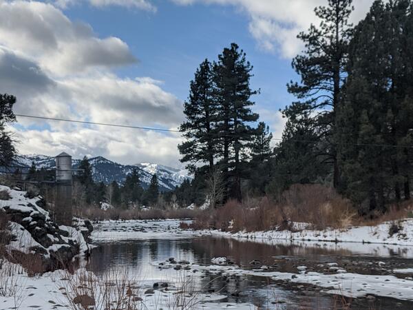
USGS gage 10308200 East fork Carson River below Markleeville, NV

Congressional event following the 6.4 earthquake in Puerto Rico
Congressional event following the 6.4 earthquake in Puerto RicoCongressional event following the 6.4 earthquake in Puerto Rico held on Jan. 20, 2020. Dr. Jonathan Godt (USGS) and Dr. Elizabeth A. Vanacore (Red Sismica Puerto Rico) answered questions to congressmen: Yauco's major, Bill Posey, Jenniffer González Colón, Stephanie Murphy, Donna Shalala
Congressional event following the 6.4 earthquake in Puerto Rico
Congressional event following the 6.4 earthquake in Puerto RicoCongressional event following the 6.4 earthquake in Puerto Rico held on Jan. 20, 2020. Dr. Jonathan Godt (USGS) and Dr. Elizabeth A. Vanacore (Red Sismica Puerto Rico) answered questions to congressmen: Yauco's major, Bill Posey, Jenniffer González Colón, Stephanie Murphy, Donna Shalala

Congressional event following the 6.4 earthquake in Puerto Rico
Congressional event following the 6.4 earthquake in Puerto RicoOverview of the Congressional event following the 6.4 earthquake in Puerto Rico. Bottom of picture: congressmen. Center: Dianne Lopez, Lindsay Davis, Donyelle Davis
Congressional event following the 6.4 earthquake in Puerto Rico
Congressional event following the 6.4 earthquake in Puerto RicoOverview of the Congressional event following the 6.4 earthquake in Puerto Rico. Bottom of picture: congressmen. Center: Dianne Lopez, Lindsay Davis, Donyelle Davis

One of the houses destroyed during the 6.4 earthquake in Puerto Rico
One of the houses destroyed during the 6.4 earthquake in Puerto RicoOne of the houses destroyed during the 6.4 earthquake in Puerto Rico.
One of the houses destroyed during the 6.4 earthquake in Puerto Rico
One of the houses destroyed during the 6.4 earthquake in Puerto RicoOne of the houses destroyed during the 6.4 earthquake in Puerto Rico.

A close-up view of the Kilauea pond
A close-up view of the Kilauea pond shows the color variations across the surface, and sharp boundaries among zones of different color.
A close-up view of the Kilauea pond shows the color variations across the surface, and sharp boundaries among zones of different color.
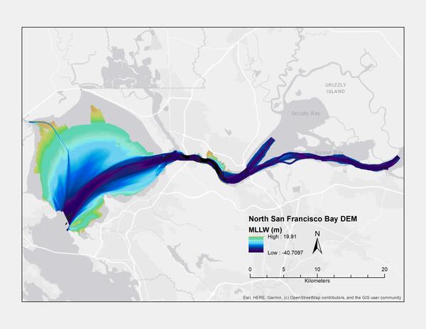
Bathymetric map of the northern portion of San Francisco Bay (MLLW)
Bathymetric map of the northern portion of San Francisco Bay (MLLW)Digital elevation model (DEM) of northern San Francisco Bay, California, created using bathymetry data collected between 1999 and 2016 (MLLW)
Bathymetric map of the northern portion of San Francisco Bay (MLLW)
Bathymetric map of the northern portion of San Francisco Bay (MLLW)Digital elevation model (DEM) of northern San Francisco Bay, California, created using bathymetry data collected between 1999 and 2016 (MLLW)

Buzzards Bay Entrance to the Cape Cod Canal
This image created using the Continuous Bathymetry and Elevation Models of the Massachusetts Coastal Zone and Continental Shelf, shows the entrance to the Buzzards Bay entrance to the Cape Cod Canal.
This image created using the Continuous Bathymetry and Elevation Models of the Massachusetts Coastal Zone and Continental Shelf, shows the entrance to the Buzzards Bay entrance to the Cape Cod Canal.

Elizabeth Islands, Massachusetts
This image created using the Continuous Bathymetry and Elevation Models of the Massachusetts Coastal Zone and Continental Shelf, shows the three-dimensional perspective view of the Elizabeth Islands in the center of the image. Buzzards Bay is to the left (north) of the Elizabeth Islands, and Vineyard Sound is to the right (south).
This image created using the Continuous Bathymetry and Elevation Models of the Massachusetts Coastal Zone and Continental Shelf, shows the three-dimensional perspective view of the Elizabeth Islands in the center of the image. Buzzards Bay is to the left (north) of the Elizabeth Islands, and Vineyard Sound is to the right (south).

Nantucket, Massachusetts
This image created using the Continuous Bathymetry and Elevation Models of the Massachusetts Coastal Zone and Continental Shelf, shows the three-dimensional perspective view of Nantucket Island, MA looking from the Southeast to the Northwest.
This image created using the Continuous Bathymetry and Elevation Models of the Massachusetts Coastal Zone and Continental Shelf, shows the three-dimensional perspective view of Nantucket Island, MA looking from the Southeast to the Northwest.

Photograph of Kīlauea summit water
After days of rain, a window of clear weather allowed HVO geologists to make observations and take measurements of the water pond at Kīlauea's summit on January 17, 2020. No major changes were observed, and the water level continues to slowly rise.
After days of rain, a window of clear weather allowed HVO geologists to make observations and take measurements of the water pond at Kīlauea's summit on January 17, 2020. No major changes were observed, and the water level continues to slowly rise.

Salem and Marblehead, Massachusetts
This image created using the Continuous Bathymetry and Elevation Models of the Massachusetts Coastal Zone and Continental Shelf, shows Salem and Marblehead in the middle of the image and Rocky Neck in the upper middle.
This image created using the Continuous Bathymetry and Elevation Models of the Massachusetts Coastal Zone and Continental Shelf, shows Salem and Marblehead in the middle of the image and Rocky Neck in the upper middle.

Scientists process volcano lake water samples
After a sample was collected, HVO team members transferred water from the sampling device to plastic bottles. Team members took notes, measured water pH and evaluated water temperature data for each sample collected.
After a sample was collected, HVO team members transferred water from the sampling device to plastic bottles. Team members took notes, measured water pH and evaluated water temperature data for each sample collected.

USGS visits areas affected by the 6.4 Puerto Rico earthquake
USGS visits areas affected by the 6.4 Puerto Rico earthquakePart of the USGS Earthquake Response Team visiting areas affected by the 6.4 earthquake. Place: Guánica Boardwalk. From left to right: Donyelle Davis, Dianne López, Jonathan Godt, Alex Grant
USGS visits areas affected by the 6.4 Puerto Rico earthquake
USGS visits areas affected by the 6.4 Puerto Rico earthquakePart of the USGS Earthquake Response Team visiting areas affected by the 6.4 earthquake. Place: Guánica Boardwalk. From left to right: Donyelle Davis, Dianne López, Jonathan Godt, Alex Grant

2020 Puerto Rico Earthquake Sequence (as of Jan. 16, 2020)
2020 Puerto Rico Earthquake Sequence (as of Jan. 16, 2020)Earthquakes detected between December 28, 2019 as of January 16, 2020. Subject to updates.
>300 M3+earthquakes recorded*
since Dec. 28, 2019 (within 40km) strong enough to be felt
10 M5+ earthquakes recorded*
since Dec. 28, 2019 (including M6.4) large enough to do damage
2020 Puerto Rico Earthquake Sequence (as of Jan. 16, 2020)
2020 Puerto Rico Earthquake Sequence (as of Jan. 16, 2020)Earthquakes detected between December 28, 2019 as of January 16, 2020. Subject to updates.
>300 M3+earthquakes recorded*
since Dec. 28, 2019 (within 40km) strong enough to be felt
10 M5+ earthquakes recorded*
since Dec. 28, 2019 (including M6.4) large enough to do damage