U.S. flag

An official website of the United States government

Images

Explore our planet through photography and imagery, including climate change and water all the way back to the 1800s when the USGS was surveying the country by horse and buggy.

Filter Total Items: 21394
liquefaction
Liquefaction and lateral spread from M6.4 earthquake in Puerto Rico

USGS scientists were deployed to assess land deformation and movement after a large M6.4 earthquake struck Puerto Rico on January 7, 2020. Here is an example of a lateral spread near a stream in Ponce, Puerto Rico.

USGS scientists were deployed to assess land deformation and movement after a large M6.4 earthquake struck Puerto Rico on January 7, 2020. Here is an example of a lateral spread near a stream in Ponce, Puerto Rico.

lateral spread
Liquefaction and lateral spread near stream in Ponce, Puerto Rico

USGS scientists were deployed to assess land deformation and movement after a large M6.4 earthquake struck Puerto Rico on January 7, 2020. Here is an example of a lateral spread near a stream in Ponce, Puerto Rico.

USGS scientists were deployed to assess land deformation and movement after a large M6.4 earthquake struck Puerto Rico on January 7, 2020. Here is an example of a lateral spread near a stream in Ponce, Puerto Rico.

land movement
Researchers deployed in Puerto Rico after earthquake

Meet the team of USGS scientists who were deployed to assess land deformation and movement after a large M6.4 earthquake struck Puerto Rico on January 7, 2020.

Meet the team of USGS scientists who were deployed to assess land deformation and movement after a large M6.4 earthquake struck Puerto Rico on January 7, 2020.

land movement
Rockfall in Ponce, Puerto Rico

USGS scientists were deployed to assess land deformation and movement after a large M6.4 earthquake struck Puerto Rico on January 7, 2020. Here is an example of rockfall material in the yard of a house in Ponce, Puerto Rico.

USGS scientists were deployed to assess land deformation and movement after a large M6.4 earthquake struck Puerto Rico on January 7, 2020. Here is an example of rockfall material in the yard of a house in Ponce, Puerto Rico.

click on image for full description
Secuencia del Terremoto en Puerto Rico, 2020 (hasta enero 16, 2020)

Terremotos detectados entre diciembre 28, 2019 hasta enero 16, 2020. Sujeto a actualizaciones.

>300 M3+ terremotos* registrados

desde dic 28, 2019 (dentro de 40km) suficientemente fuerte como para ser sentido

10 M5+ terremotos* registrados

Terremotos detectados entre diciembre 28, 2019 hasta enero 16, 2020. Sujeto a actualizaciones.

>300 M3+ terremotos* registrados

desde dic 28, 2019 (dentro de 40km) suficientemente fuerte como para ser sentido

10 M5+ terremotos* registrados

image related to volcanoes. See description
Water pond in Halema‘uma‘u continues to grow

Comparison of the water pond in Halema‘uma‘u on November 20, 2019, and March 1, 2020. Camera and lens same for both photos. Since November 20, 2019, the pond deepened 10 m (33 ft) and widened more than 50 m (164 ft) east-west and 30 m (98 ft) north-south. Circled clusters of rocks did not move between photos, evidence of slope stability.

Comparison of the water pond in Halema‘uma‘u on November 20, 2019, and March 1, 2020. Camera and lens same for both photos. Since November 20, 2019, the pond deepened 10 m (33 ft) and widened more than 50 m (164 ft) east-west and 30 m (98 ft) north-south. Circled clusters of rocks did not move between photos, evidence of slope stability.

HABS platform pull on Skaneateles Lake

Photo Contest Winner | Jan. 2020 | Where We Work
John Wernly and Andrew Kowalczk after HABS platform pull on Skaneateles Lake

Photo Contest Winner | Jan. 2020 | Where We Work
John Wernly and Andrew Kowalczk after HABS platform pull on Skaneateles Lake

Nighttime Landsat 8 image of the Taal Volcano

This image shows a false color (bands 7,6,5) nighttime Landsat 8 image of the Taal Volcano overlaid on a daytime Landsat panchromatic black and white image (band 8). The nighttime image from path 220/row194 was acquired on January 15, 2020, a few days after the volcano's eruption.

This image shows a false color (bands 7,6,5) nighttime Landsat 8 image of the Taal Volcano overlaid on a daytime Landsat panchromatic black and white image (band 8). The nighttime image from path 220/row194 was acquired on January 15, 2020, a few days after the volcano's eruption.

USGS team with Wanda Vazquez-Garced, governor of Puerto Rico
USGS Earthquake Response team with governor of Puerto Rico

USGS team with Wanda Vazquez-Garced, governor of Puerto Rico. From left to right: Lindsay Davis, Wanda Vazquez, Dianne Lopez-Trujillo, Jonathan Godt, Donyelle Davis, Alex Grant

Three people looking at instrumentation
Analyzing Earthquake Data in Puerto Rico

USGS scientists Thomas L. Pratt and Alena L. Leads, along with Dr. Elizabeth Vanacore, associate research professor at University of Puerto Rico, analyze data in earthquake monitoring and recording equipment amid aftershocks across the island's southern coast.

USGS scientists Thomas L. Pratt and Alena L. Leads, along with Dr. Elizabeth Vanacore, associate research professor at University of Puerto Rico, analyze data in earthquake monitoring and recording equipment amid aftershocks across the island's southern coast.

drilling holes through the ice
Drilling Holes Through the Ice

Stream stage is still accurately measured by equip under ice, and fluctuates a fair amount due to ice damming and accumulation. Streamflow, however, during most of the winter is typically quite stable.

Stream stage is still accurately measured by equip under ice, and fluctuates a fair amount due to ice damming and accumulation. Streamflow, however, during most of the winter is typically quite stable.

Photograph of scientist monitoring crater lake
HVO scientist tests colorimeter instrument at Kīlauea's summit

An HVO scientist tests a colorimeter instrument on the water lake within Halema‘uma‘u, at Kīlauea's summit. Colorimetry is the measurement of the wavelength and intensity of light. USGS photo by M. Patrick. 

An HVO scientist tests a colorimeter instrument on the water lake within Halema‘uma‘u, at Kīlauea's summit. Colorimetry is the measurement of the wavelength and intensity of light. USGS photo by M. Patrick. 

winter streamflow measurement
Winter Streamflow Measurement

Stream stage is still accurately measured by equip under ice, and fluctuates a fair amount due to ice damming and accumulation. Streamflow, however, during most of the winter is typically quite stable.

Stream stage is still accurately measured by equip under ice, and fluctuates a fair amount due to ice damming and accumulation. Streamflow, however, during most of the winter is typically quite stable.

image related to volcanoes. See description
A pack string crossing the Yellowstone River in the remote Thorofare region

A pack string crossing the Yellowstone River in the remote Thorofare region. National Park Service photo courtesy of Sherrie and Ron White, August 21, 2016.

Landsat 8 image of Phoenix, Arizona

Landsat 8 image of Phoenix, Arizona, acquired on January 13, 2020 (Path 37 Row 36).  This false color image uses the short-wave infrared, near infrared, and red bands (bands 6, 5, 4) to display the data.

For more information about Landsat, please visit www.usgs.gov/Landsat

Landsat 8 image of Phoenix, Arizona, acquired on January 13, 2020 (Path 37 Row 36).  This false color image uses the short-wave infrared, near infrared, and red bands (bands 6, 5, 4) to display the data.

For more information about Landsat, please visit www.usgs.gov/Landsat

seismic stations
Installing a temporary seismometer

Photo (L-R) Jose Cancel of Puerto Rico Seismic Network (PRSN), Alena Leeds of USGS and Javier Santiago of PRSN install a temporary seismometer at Sabana Yeguas in southwestern Puerto Rico on Jan. 10, 2020.

Photo (L-R) Jose Cancel of Puerto Rico Seismic Network (PRSN), Alena Leeds of USGS and Javier Santiago of PRSN install a temporary seismometer at Sabana Yeguas in southwestern Puerto Rico on Jan. 10, 2020.

Imperial Geyser with colorful water. Yellowstone
Imperial Geyser looking south, Yellowstone

Imperial Geyser hot spring pool in Yellowstone National Park is about 30 m (about 100 ft) across and contains alkaline-Cl waters with a steam vent in the pool and mudpots outside the pool area (in the upper right part of this photo). USGS Photo by Pat Shanks, 2019.

Imperial Geyser hot spring pool in Yellowstone National Park is about 30 m (about 100 ft) across and contains alkaline-Cl waters with a steam vent in the pool and mudpots outside the pool area (in the upper right part of this photo). USGS Photo by Pat Shanks, 2019.

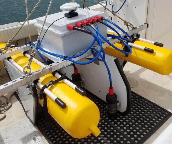
Scientific equipment mounted on two yellow pontoons sitting on the deck of a research vessel
SQUID-5 - Structure-from-Motion Quantitative Underwater Imaging Device

The SQUID-5, or a Structure-from-Motion (SfM) Quantitative Underwater Imaging Device with 5 cameras is a towed surface vehicle with an onboard Global Navigation Satellite System (GNSS) and 5 downward-looking cameras with overlapping views of the seafloor.

image related to volcanoes. See description
Visitors in the busy Old Faithful area

Visitors in the busy Old Faithful area. National Park Service photo by Neal Herbert, May 27, 2017.

Visitors in the busy Old Faithful area. National Park Service photo by Neal Herbert, May 27, 2017.

Was this page helpful?