
Trunks of forest trees, initially growing on a terrace above the Sandy River (Oregon) at Oxbow Regional Park, were buried by rapid deposition of sediment following a dome-building eruption at Mount Hood in 1781. Erosion during a flood about a week before the photo was taken exposed this "ghost forest".
Images
Volcano Hazard Program images.
Filter Total Items: 6274

Trees Buried in Volcanic Sediment, Sandy River 2
Trunks of forest trees, initially growing on a terrace above the Sandy River (Oregon) at Oxbow Regional Park, were buried by rapid deposition of sediment following a dome-building eruption at Mount Hood in 1781. Erosion during a flood about a week before the photo was taken exposed this "ghost forest".

Science Collaboration on Tanzanian Hazards
USGS Scientist Gari Mayberry discusses the volcano hazards in Tanzania with a scientist from the Geological Survey of Tanzania.
USGS Scientist Gari Mayberry discusses the volcano hazards in Tanzania with a scientist from the Geological Survey of Tanzania.

Cinder Cone in Lassen Volcanic National Park
Cinder Cone erupted in the year 1666 in the Lassen Volcanic Region of northern California.
Cinder Cone erupted in the year 1666 in the Lassen Volcanic Region of northern California.

Waikupanaha ocean entry
Activity at the west Waikupanaha ocean entry, where lava reached the ocean this past weekend, continues. The entry spans about 200 m, with many small lava streams entering the water.
Activity at the west Waikupanaha ocean entry, where lava reached the ocean this past weekend, continues. The entry spans about 200 m, with many small lava streams entering the water.

Aerial view west across the upper part of Medicine Lake Volcano tow...
Aerial view west across the upper part of Medicine Lake Volcano tow...Medicine Lake lies within the shallow basin of Medicine Lake caldera. Glass Mountain flow, draped over the east side of the volcano, is the youngest lava flow at the volcano. The northeasternmost dacite tongue extends nearly to the bottom of the photo (distal lobes are outlined to enhance visibility).

Vog obscures view during slack or no tradewinds at summit of Kīlauea
Vog obscures view during slack or no tradewinds at summit of KīlaueaVog obscures view during slack or no tradewinds at the summit of Kīlauea Volcano, Hawai‘i
Vog obscures view during slack or no tradewinds at summit of Kīlauea
Vog obscures view during slack or no tradewinds at summit of KīlaueaVog obscures view during slack or no tradewinds at the summit of Kīlauea Volcano, Hawai‘i

Crater Lake, Chaski Bay. Talus slope sits on flat top of massive sl...
Crater Lake, Chaski Bay. Talus slope sits on flat top of massive sl...View southwest of Garfield Peak and Eagle Crags above Chaski Bay. Cliffs at caldera rim are andesite of Applegate Peak (unit aa; ca. 210-270 ka), overlain by two thin flows of andesite of Garfield Peak at top center (unit ag; 224 ±9 ka). Talus rests on flat top of massive slide block that consists of altered lavas of units aa, ak(?), and db(?).

Sun Creek Valley with Crater Lake in background, aerial view lookin...
Sun Creek Valley with Crater Lake in background, aerial view lookin...Morning aerial view looking northwest up the valley of Sun Creek. Applegate Peak caps the prominent rock wall of the west side of Sun Notch at the caldera rim. Northwest caldera wall is visible on opposite side of Crater Lake through Sun Notch. Grayback Ridge in foreground is thick lava of pre-Mazama rhyodacite (410-460 ka).

Installing geophysical boreholes in Yellowstone
UNAVCO engineers drilling a borehole for instrument installation (left). Aerial view of borehole casing used to protect instruments from the elements found below the surface (right).
UNAVCO engineers drilling a borehole for instrument installation (left). Aerial view of borehole casing used to protect instruments from the elements found below the surface (right).

Eruptions in the Cascade Range during the past 4000 years. USGS GIP 64
Eruptions in the Cascade Range during the past 4000 years. USGS GIP 64Eruptions in the Cascade Range during the past 4000 years. USGS GIP 64
Eruptions in the Cascade Range during the past 4000 years. USGS GIP 64
Eruptions in the Cascade Range during the past 4000 years. USGS GIP 64Eruptions in the Cascade Range during the past 4000 years. USGS GIP 64

Side-by-side comparison of the NW wall of Kīlauea Caldera on a clea...
Side-by-side comparison of the NW wall of Kīlauea Caldera on a clea...Side-by-side comparison of the northwest wall of Kīlauea Caldera on a clear day (left) and a day with thick vog (right). HVO observation tower and building can be seen near the center in each photo.

Geologist on rim of Halema‘uma‘u downloading camera images, Kīlauea...
Geologist on rim of Halema‘uma‘u downloading camera images, Kīlauea...HVO geologist downloads images collected with infrared cameras set up on the rim of Halema‘uma‘u Crater. The cameras are aimed at an erupting lava lake to conduct a thermal survey of the lake's surface.

Seismologist installing equipment at station NED on Mount St. Helen...
Seismologist installing equipment at station NED on Mount St. Helen...Seismologist installing equipment at station NED on Mount St. Helens, Washington. Mount Rainier in distance.
Seismologist installing equipment at station NED on Mount St. Helen...
Seismologist installing equipment at station NED on Mount St. Helen...Seismologist installing equipment at station NED on Mount St. Helens, Washington. Mount Rainier in distance.

Sulfur flow (darker gray area) on an altered ground surface at Brim...
Sulfur flow (darker gray area) on an altered ground surface at Brim...Sulfur flow (darker gray area) on an altered ground surface at Brimstone Basin, Yellowstone Lake in background.
Sulfur flow (darker gray area) on an altered ground surface at Brim...
Sulfur flow (darker gray area) on an altered ground surface at Brim...Sulfur flow (darker gray area) on an altered ground surface at Brimstone Basin, Yellowstone Lake in background.

Gas flows up, appearing to boil, through the water of Alluvium Cree...
Gas flows up, appearing to boil, through the water of Alluvium Cree...Gas flows up, appearing to boil, through the water of Alluvium Creek, Brimstone Basin, Yellowstone. Large funnel is used to trap gas, which is then sent to a collection bottle through the tubing.

Gas flux measurement taken over altered ground at Brimstone Basin
Gas flux measurement taken over altered ground at Brimstone BasinGas flux measurement being taken over altered ground at Brimstone Basin, Yellowstone.
Gas flux measurement taken over altered ground at Brimstone Basin
Gas flux measurement taken over altered ground at Brimstone BasinGas flux measurement being taken over altered ground at Brimstone Basin, Yellowstone.

Volcanic-gas plumes emitted by ocean entry, Pu‘u ‘Ō‘ō vent, and Hal...
Volcanic-gas plumes emitted by ocean entry, Pu‘u ‘Ō‘ō vent, and Hal...Volcanic-gas plumes mark the sites where lava flows from Pu‘u ‘Ō‘ō enter the ocean on Kīlauea's south coast (far left), the Pu‘u ‘Ō‘ō cone (left) on the East Rift Zone, and Halema‘uma‘u Crater at the summit (right). Structures visible in middle left primarily located around the Volcano Golf and Country Club and Kīlauea Military Camp.

Hawaiian Volcano Observatory field geologists track activity at fissure 8 (pictu
Hawaiian Volcano Observatory field geologists track activity at fissure 8 (pictuHawaiian Volcano Observatory field geologists track activity at fissure 8 (pictured in the background). Crews collect fissure 8 tephra (Pele's hair, pumice, and other lightweight volcanic glass fragments) for geochemical analyses and characterization of changes in lava fountain behavior.

HVO on rim of Kīlauea's summit caldera overlooking Halema‘uma‘u, Ha...
HVO on rim of Kīlauea's summit caldera overlooking Halema‘uma‘u, Ha...The U.S. Geological Survey's Hawaiian Volcano Observatory, the first volcano observatory in the United States, is located on the west rim of Kīlauea Volcano's summit caldera in Hawai‘i Volcanoes National Park. A volcanic gas plume rises from a vent that opened in 2008 at the base of the south wall of Halema‘uma‘u Crater. Crater Rim Drive in foreground.
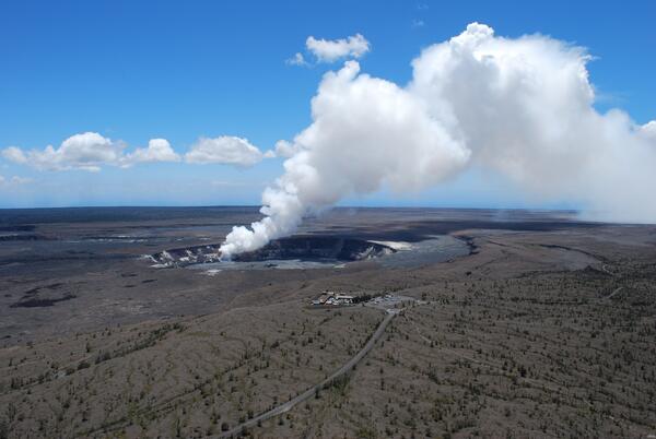
The USGS Hawaiian Volcano Observatory Monitors Kilauea's Summit Eruption
The USGS Hawaiian Volcano Observatory Monitors Kilauea's Summit EruptionThe USGS Hawaiian Volcano Observatory (foreground) is located on the caldera rim of Kilauea Volcano, Hawai'ithe most active volcano in the world. The observatory's location provides an excellent view of summit eruptive activity, which began in 2008.

USGS Hawaiian Volcano Observatory Monitors Kilauea's Summit Eruption
USGS Hawaiian Volcano Observatory Monitors Kilauea's Summit EruptionThe USGS Hawaiian Volcano Observatory (foreground) is located on the caldera rim of Kilauea Volcano, Hawai'i—the most active volcano in the world. The observatory's location provides an excellent view of summit eruptive activity, which began in 2008.