U.S. flag

An official website of the United States government

Images

Volcano Hazard Program images.

Filter Total Items: 6279
Wooden fence on edge of Halema‘uma‘u Overlook area damaged by explo...

The explosion occurred at 2:58 a.m. HST on March 19, 2008. The explosion scattered rock debris over an area of about 30 hectares (75 acres), covering a portion of Crater Rim Drive and damaging Halema‘uma‘u Overlook. The wooden fence of the overlook was bombarded by rocks hurled onto the rim of Halema‘uma‘u crater from the fumarolic area.

The explosion occurred at 2:58 a.m. HST on March 19, 2008. The explosion scattered rock debris over an area of about 30 hectares (75 acres), covering a portion of Crater Rim Drive and damaging Halema‘uma‘u Overlook. The wooden fence of the overlook was bombarded by rocks hurled onto the rim of Halema‘uma‘u crater from the fumarolic area.

Early morning view of fumarolic area at the base of eastern wall of...

This fumarolic area appeared on March 12, 2008. Gas is being emitted through rubble the Halema‘uma‘u Crater wall. The white fume is a mixture of condensed water vapor, sulfur trioxide, and invisible sulfur dioxide. The fume takes a pale bluish color if it contains very tiny sulfur particles (in center of fuming area).

This fumarolic area appeared on March 12, 2008. Gas is being emitted through rubble the Halema‘uma‘u Crater wall. The white fume is a mixture of condensed water vapor, sulfur trioxide, and invisible sulfur dioxide. The fume takes a pale bluish color if it contains very tiny sulfur particles (in center of fuming area).

Glass Mountain obsidian flow at Medicine Lake volcano, California....
Glass Mountain obsidian flow at Medicine Lake volcano, CA.

Glass Mountain obsidian flow at Medicine Lake volcano, California. Glass Mountain is a spectacular, nearly treeless, steep-sided rhyolite and dacite obsidian flow that erupted just outside the eastern caldera rim and flowed down the steep eastern flank of Medicine Lake volcano.

Glass Mountain obsidian flow at Medicine Lake volcano, California. Glass Mountain is a spectacular, nearly treeless, steep-sided rhyolite and dacite obsidian flow that erupted just outside the eastern caldera rim and flowed down the steep eastern flank of Medicine Lake volcano.

Stream of lava from Pu‘u ‘Ō‘ō flowing through the forest in the Roy...

Stream of lava from Pu‘u ‘Ō‘ō flowing through the forest in the Royal Gardens subdivision, February 28, 2008. The lava stream is about 3 m (10 ft) wide. Kīlauea Volcano, Hawai‘i.

HVO technicians working on seismic station at summit of Kīlauea Vol...
HVO technicians working seismic station at summit of Kīlauea

HVO technicians install a solar-powered seismic station near the summit of Kīlauea Volcano to monitor earthquake activity. The seismic data is transmitted via radio signal directly to the observatory, where the data is initially analyzed by automatic computer programs and then examined in greater detail by a seismologist. Mauna Loa Volcano in background.

HVO technicians install a solar-powered seismic station near the summit of Kīlauea Volcano to monitor earthquake activity. The seismic data is transmitted via radio signal directly to the observatory, where the data is initially analyzed by automatic computer programs and then examined in greater detail by a seismologist. Mauna Loa Volcano in background.

Image: Vog from Kilauea
Vog from Kilauea
Vog from Kilauea
Vog from Kilauea

The rim of Kīlauea Volcano’s summit caldera, normally clear on trade-wind days (left), became nearly obscured by vog (right) on some non-trade wind days beginning in 2008, when sulfur dioxide emissions from the volcano’s summit increased to unusually high levels. (This photo has been edited.)

The rim of Kīlauea Volcano’s summit caldera, normally clear on trade-wind days (left), became nearly obscured by vog (right) on some non-trade wind days beginning in 2008, when sulfur dioxide emissions from the volcano’s summit increased to unusually high levels. (This photo has been edited.)

North Sister volcano's east face (750 m, 2460 ft high) consists of ...

East face of North Sister, 750 m high. Consists of about 100 thin mafic lava flows and intercalated layers of red scoria, capped by thick summit lava flows. Remnant of Thayer Glacier feeds cirque lake. Pervasively altered yellow-orange buttress on right, 250 m thick, consists of east-dipping, palagonitized, ash-rich fragmental flow deposits.

East face of North Sister, 750 m high. Consists of about 100 thin mafic lava flows and intercalated layers of red scoria, capped by thick summit lava flows. Remnant of Thayer Glacier feeds cirque lake. Pervasively altered yellow-orange buttress on right, 250 m thick, consists of east-dipping, palagonitized, ash-rich fragmental flow deposits.

South Sister's northwest summit, basaltic andesite lava and scoria ...
South Sister's northwest summit, basaltic andesite lava and scoria cap the volcano.

Lost Creek Glacier and its cirque are in the center, and Eugene Glacier and its cirque are toward the bottom left. Fingerlike lobes of dacite lava dribble down northwest ridge atop fragmental deposit and beneath capping agglutinate. The entire edifice visible here was built between 30 and 20 ka.

Lost Creek Glacier and its cirque are in the center, and Eugene Glacier and its cirque are toward the bottom left. Fingerlike lobes of dacite lava dribble down northwest ridge atop fragmental deposit and beneath capping agglutinate. The entire edifice visible here was built between 30 and 20 ka.

South, Middle, and North Sister volcanoes viewed aerially from the ...
South, Middle, and North Sister volcanoes,Three Sisters OR.

South, Middle, and North Sister volcanoes viewed aerially from the south, Three Sisters Oregon.

Broken Top volcano, inactive since 150 ka or longer, viewed to the ...
Broken Top volcano, inactive since 150 ka or longer, viewed to NW. ...

Radially dipping strata of the cone include subequal proportions of lava flows and flow breccias and of proximal agglutinate and scoria falls, nearly all having 54 to 56 percent SiO2. Numerous mafic dikes and sills intrude the cone, and an apron of compositionally similar mafic lavas extends far outward from the cone.

Radially dipping strata of the cone include subequal proportions of lava flows and flow breccias and of proximal agglutinate and scoria falls, nearly all having 54 to 56 percent SiO2. Numerous mafic dikes and sills intrude the cone, and an apron of compositionally similar mafic lavas extends far outward from the cone.

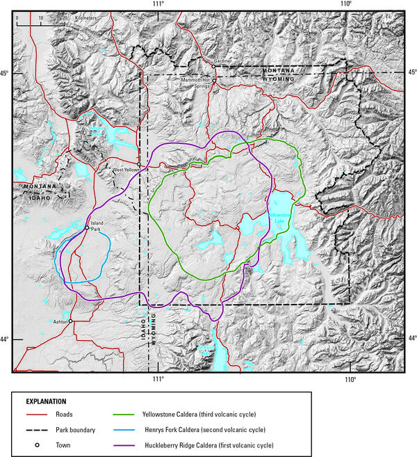
Digital elevation model of Yellowstone National Park and vicinity

Digital elevation model of Yellowstone National Park and vicinity, showing the location of the calderas formed during each of Yellowstone’s three most recent volcanic cycles. The youngest caldera-forming eruption produced Yellowstone Caldera (green line), located within Yellowstone National Park.

Digital elevation model of Yellowstone National Park and vicinity, showing the location of the calderas formed during each of Yellowstone’s three most recent volcanic cycles. The youngest caldera-forming eruption produced Yellowstone Caldera (green line), located within Yellowstone National Park.

South Sister volcano's northeast face with stacks of andesite lava ...
South Sister volcano's northeast face with stacks of andesite lava flows and oxidized (red colored) scoria.

Prouty Glacier headwall on the northeast face of South Sister. Dipping stacks of lava and scoria were excavated by Prouty Glacier, exposing cross-sectional views of the last 33,000 years of summit activity. The 350-m-thick (11,500-ft) lava stacks are truncated at about 3000 m (9,800 ft) elevation, forming the ragged rim of a broad paleocrater.

Prouty Glacier headwall on the northeast face of South Sister. Dipping stacks of lava and scoria were excavated by Prouty Glacier, exposing cross-sectional views of the last 33,000 years of summit activity. The 350-m-thick (11,500-ft) lava stacks are truncated at about 3000 m (9,800 ft) elevation, forming the ragged rim of a broad paleocrater.

Lava cascades out of perched lava channel into lower channel, Pu‘u ...

On July 21, 2007, an erupting fissure opened on the east flank of Pu‘u ‘Ō‘ō and propagated eastward toward Kupaianaha.

Contact between Huckleberry Ridge Tuff ignimbrite members B and C

The contact (red arrow) between Huckleberry Ridge Tuff ignimbrite members B and C is marked by a time break of probably years to a few decades.

Mount Shasta, California...
Mount Shasta, CA
Mount Shasta, CA
Mount Shasta, CA

Aerial photo of Mount Shasta's southwestern flank in a low-snow period. The Hotlum cone is on the right, while the Shastina dome is to the left.

Aerial photo of Mount Shasta's southwestern flank in a low-snow period. The Hotlum cone is on the right, while the Shastina dome is to the left.

Loowit Falls and channel flowing toward the north through the east ...
Was this page helpful?