
Collapsed arch in Guayanilla, Puerto Rico.
Images
Explore photos, graphics, and illustrations related to projects from across the CASC Network. And be sure to check out our Climate Illustrations page, featuring free-to-download illustrations that help describe tricky climate concepts and explain how climate change affects the world around us.
Filter Total Items: 639

Collapsed arch
Collapsed arch in Guayanilla, Puerto Rico.

California coastal erosion
This region of the California coastline is lined with coastal bluffs that have been shaped not only by runoff from rain, but also by wave- and wind-driven erosion. This photo from Pescadero State Beach displays an example of a bluff undergoing erosional processes. Water from the ocean, delivered in waves, can overtop some of these coastal bluffs.
This region of the California coastline is lined with coastal bluffs that have been shaped not only by runoff from rain, but also by wave- and wind-driven erosion. This photo from Pescadero State Beach displays an example of a bluff undergoing erosional processes. Water from the ocean, delivered in waves, can overtop some of these coastal bluffs.

Post-Fire Landscape
Snag fall after the 2011 Las Conchas Fire, which burned over 150,000 acres in New Mexico.
Snag fall after the 2011 Las Conchas Fire, which burned over 150,000 acres in New Mexico.

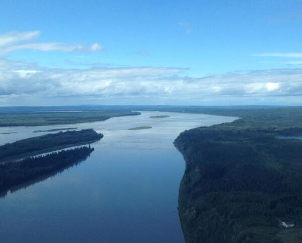
The Yukon River, Alaska
The Yukon River near St. Mary’s, Alaska.
The Yukon River near St. Mary’s, Alaska.

Arctic National Wildlife Refuge-1002 Area near the Sadlerochit River
Arctic National Wildlife Refuge-1002 Area near the Sadlerochit RiverNorthward view in central Arctic National Wildlife Refuge-1002 Area near the Sadlerochit River showing gently rolling topography typical of the southern coastal plain and meandering creek.

Taking water quality samples in Alaska
Earl Alstrom and Carol Hasburgh taking water quality samples near St. Mary’s, Alaska.
Earl Alstrom and Carol Hasburgh taking water quality samples near St. Mary’s, Alaska.

View South from Wolverine Glacier
View South from Wolverine Glacier

Dandelion, side
Taraxacum officinale, common dandelion found in lawn of building 308 at the Beltsville Agriculture Research Center, Beltsville, MD
Taraxacum officinale, common dandelion found in lawn of building 308 at the Beltsville Agriculture Research Center, Beltsville, MD
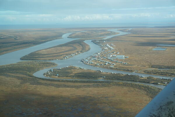
The Yukon River, Alaska.
The Yukon River near Pilot Station, Alaska.
The Yukon River near Pilot Station, Alaska.

Seagull on Indian Rocks Beach, Florida
Seagull on Indian Rocks Beach, Florida
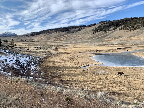
Bison in Yellowstone National Park’s Northern Range
Bison in Yellowstone National Park’s Northern RangeBison in Yellowstone National Park’s Northern Range, where scenario planning work is currently underway.
Bison in Yellowstone National Park’s Northern Range
Bison in Yellowstone National Park’s Northern RangeBison in Yellowstone National Park’s Northern Range, where scenario planning work is currently underway.

Arid grassland
Arid grasslands in the U.S. Mexico border are fire adapted and used by diverse groups. Science from the Southwest Biological Science Center and the Restoration Assessment and Monitoring Program for the Southwest (RAMPS) is helping these groups find common ground to manage this dynamic landscape.
Arid grasslands in the U.S. Mexico border are fire adapted and used by diverse groups. Science from the Southwest Biological Science Center and the Restoration Assessment and Monitoring Program for the Southwest (RAMPS) is helping these groups find common ground to manage this dynamic landscape.

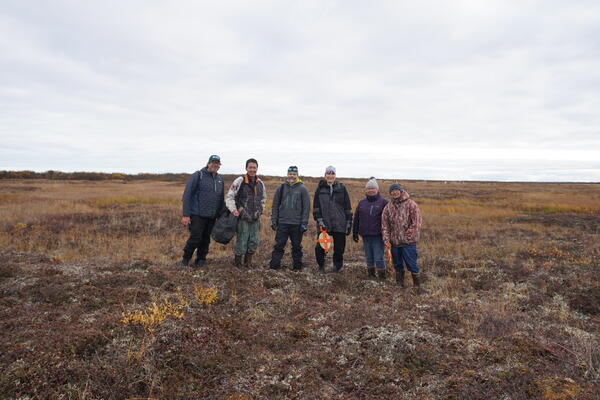
Taking Active Layer Network measurements, Alaska
Malinda Chase (AK CASC Tribal Liaison), Jeremy Littell (AK CASC Lead Scientist), Victor Tonuchuk, Jr., Philomena Keyes, and Bernard TKTKTK taking Active Layer Network measurements in Kotlik, Alaska.
Malinda Chase (AK CASC Tribal Liaison), Jeremy Littell (AK CASC Lead Scientist), Victor Tonuchuk, Jr., Philomena Keyes, and Bernard TKTKTK taking Active Layer Network measurements in Kotlik, Alaska.

Members of the Kotlik (Querrullik) governance
Various members of the Kotlik (Querrullik) governance talking about environmental changes for the Building Resilience Project.
Various members of the Kotlik (Querrullik) governance talking about environmental changes for the Building Resilience Project.
Active Layer Network, Alaska.
From left to right: Ryan Toohey, Bernard TKTKTK, Jeremy Littell (AK CASC Lead Scientist), Malinda Chase (AK CASC Tribal Liaison), Philomena Keyes, and Victor Tonuchuk, Jr. at the Active Layer Network site in Kotlik, Alaska.
From left to right: Ryan Toohey, Bernard TKTKTK, Jeremy Littell (AK CASC Lead Scientist), Malinda Chase (AK CASC Tribal Liaison), Philomena Keyes, and Victor Tonuchuk, Jr. at the Active Layer Network site in Kotlik, Alaska.
The governance of Kotlik (Querrullik), Alaska
The governance of Kotlik (Querrullik) in Alaska.
The governance of Kotlik (Querrullik) in Alaska.

Rainbow trout in Lees Ferry, Colorado River
A group of rainbow trout swims upstream in the Lees Ferry fishery downstream of Glen Canyon Dam in the Colorado River.
A group of rainbow trout swims upstream in the Lees Ferry fishery downstream of Glen Canyon Dam in the Colorado River.

A person fishing for trout in Lees Ferry, Colorado River
A person fishing for trout in Lees Ferry, Colorado RiverA person fishing for rainbow trout or brown trout in the Lees Ferry fishery in the Colorado River downstream of Glen Canyon Dam in Grand Canyon National Park.
A person fishing for trout in Lees Ferry, Colorado River
A person fishing for trout in Lees Ferry, Colorado RiverA person fishing for rainbow trout or brown trout in the Lees Ferry fishery in the Colorado River downstream of Glen Canyon Dam in Grand Canyon National Park.

Ice-rich permafrost bluffs on the bank of the Canning River, Alaska
Ice-rich permafrost bluffs on the bank of the Canning River, AlaskaIce-rich permafrost exerts a strong control on hydrology in Arctic regions because it limits infiltration, leading to large runoff events.
Ice-rich permafrost bluffs on the bank of the Canning River, Alaska
Ice-rich permafrost bluffs on the bank of the Canning River, AlaskaIce-rich permafrost exerts a strong control on hydrology in Arctic regions because it limits infiltration, leading to large runoff events.
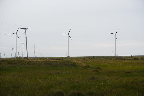
Windfarm at Quinhagak, Alaska.
Windfarm at Quinhagak, Alaska. In this photo, the telephone poles are leaning due to permafrost thaw.
Windfarm at Quinhagak, Alaska. In this photo, the telephone poles are leaning due to permafrost thaw.
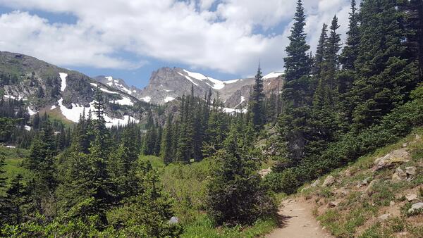
NDTc - Trail in the Indian Peaks Wilderness area located in Colorado
NDTc - Trail in the Indian Peaks Wilderness area located in ColoradoA scenic view of the Indian Peaks Wilderness Area located in Colorado. The hike begins at the Long Lake Trail-head and guides to Lake Isabelle at 10,868 ft (3313 m).