The Santa Ana River is the largest river entirely within Southern California in the United States.
Images
Explore photos, graphics, and illustrations related to projects from across the CASC Network. And be sure to check out our Climate Illustrations page, featuring free-to-download illustrations that help describe tricky climate concepts and explain how climate change affects the world around us.
Filter Total Items: 639

Santa Ana River calm day
The Santa Ana River is the largest river entirely within Southern California in the United States.
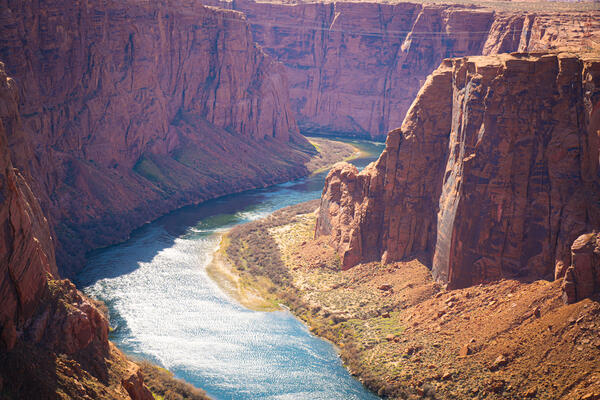
Colorado River in the Grand Canyon
View of Colorado River in the Grand Canyon from overlook. Photo by Jordan Bush, ORISE participant, National USGS CASC.
View of Colorado River in the Grand Canyon from overlook. Photo by Jordan Bush, ORISE participant, National USGS CASC.

USGS scientist examines juvenile smallmouth bass in a laboratory
USGS scientist examines juvenile smallmouth bass in a laboratoryThe USGS partners with the U.S. Fish and Wildlife Service to run a fish laboratory, where they run experiments to see how native and invasive fish interact. Here, biologist Drew Eppehimer transports two juvenile smallmouth bass to a new tank.

Tree Rings
The secret lives of... trees? Trees can live for hundreds and sometimes thousands of years. As they grow, they add new layers of growth – or tree rings – that scientists can study to learn about the tree’s life. The width of tree rings often reflects the factor most influencing growth from one year to the next depending upon where the tree lives.
The secret lives of... trees? Trees can live for hundreds and sometimes thousands of years. As they grow, they add new layers of growth – or tree rings – that scientists can study to learn about the tree’s life. The width of tree rings often reflects the factor most influencing growth from one year to the next depending upon where the tree lives.

Ice Cores
The cold never bothered our USGS scientists! They ask – do you want to collect an ice core?
The cold never bothered our USGS scientists! They ask – do you want to collect an ice core?

Sediment Core
Time to get our hands dirty! Paleoclimate researchers study sediment cores, which are accumulated layers of mud and dead plant material collected in a long tube, to learn about what the climate and environment of the past was like.
Time to get our hands dirty! Paleoclimate researchers study sediment cores, which are accumulated layers of mud and dead plant material collected in a long tube, to learn about what the climate and environment of the past was like.

Continuum of Wildland to Urban Densities
All of Earth’s ecosystems are directly or indirectly impacted by humans. But landscapes where people live, work, and travel can become dominated by people, such that the built environment and people’s daily activities control major ecological processes.
All of Earth’s ecosystems are directly or indirectly impacted by humans. But landscapes where people live, work, and travel can become dominated by people, such that the built environment and people’s daily activities control major ecological processes.

Aerial view of Ucluelet, Vancouver Island, British Columbia
Aerial view of Ucluelet, Vancouver Island, British ColumbiaAerial view of Ucluelet, Vancouver Island, British Columbia, showing coastal mountains along the Queen Charlotte Fault zone.
Aerial view of Ucluelet, Vancouver Island, British Columbia
Aerial view of Ucluelet, Vancouver Island, British ColumbiaAerial view of Ucluelet, Vancouver Island, British Columbia, showing coastal mountains along the Queen Charlotte Fault zone.
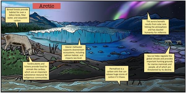
Arctic Ecosystem
Arctic Ecosystems are at the forefront of climate change and many of the ecosystem services they provide are rapidly threatened or changing.
You can find more Climate Illustrations here.
Arctic Ecosystems are at the forefront of climate change and many of the ecosystem services they provide are rapidly threatened or changing.
You can find more Climate Illustrations here.
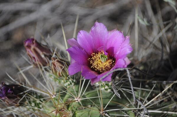
Copia de Opuntia imbricata_Mapimí, Dgo - MEZ.JPG
A picture of a pink flower on an Opuntia cactus, also known as a prickly pear cactus.
A picture of a pink flower on an Opuntia cactus, also known as a prickly pear cactus.

darby.jpg
The Bitterroot River in Darby, Montana taken by Roger Peterson of US Forest Service.
The Bitterroot River in Darby, Montana taken by Roger Peterson of US Forest Service.
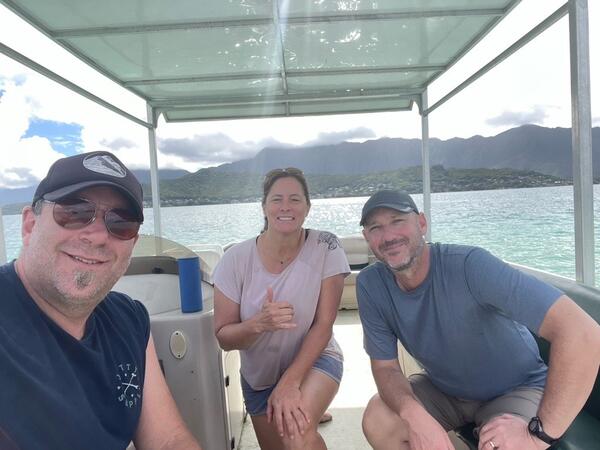
Meeting between PI-AK collaborators
Staff from the Pacific Islands and Alaska CASCs meet to discuss commonalities between their two regions.
Staff from the Pacific Islands and Alaska CASCs meet to discuss commonalities between their two regions.

Water-quality sensors on the Willamette River, Jasper Oregon
Water-quality sensors on the Willamette River, Jasper OregonThe grey PVC pipe is securely mounted on the river bank to house water-quality instruments.
Water-quality sensors on the Willamette River, Jasper Oregon
Water-quality sensors on the Willamette River, Jasper OregonThe grey PVC pipe is securely mounted on the river bank to house water-quality instruments.

Scientist collects water sample in the Grand Canyon
Scientist collects water sample in the Grand CanyonUSGS scientist collects a water-quality sample in the Grand Canyon, Arizona.
Scientist collects water sample in the Grand Canyon
Scientist collects water sample in the Grand CanyonUSGS scientist collects a water-quality sample in the Grand Canyon, Arizona.

Upper Mississippi River Restoration
Upper Mississippi River Restoration program partners meet in the field to discuss a backwater habitat rehabilitation project in Pool 4 of the Mississippi.
Upper Mississippi River Restoration program partners meet in the field to discuss a backwater habitat rehabilitation project in Pool 4 of the Mississippi.

Cottonwood Pass, Colorado
A view westward from Cottonwood Pass (Sawatch Range, Colorado, USA) into the Taylor Park basin. The peaks in the backgorund are composed of igneous and metamorphic rocks ranging in age from early Paleozoic to Eocene, uplifted along the Taylor Park fault.
A view westward from Cottonwood Pass (Sawatch Range, Colorado, USA) into the Taylor Park basin. The peaks in the backgorund are composed of igneous and metamorphic rocks ranging in age from early Paleozoic to Eocene, uplifted along the Taylor Park fault.

USGS Communicates Climate Info to Partners
The USGS produces national and regional climate data sets, including downscaled climate projections, to help resource managers and local communities understand potential effects of climate change in their areas.
The USGS produces national and regional climate data sets, including downscaled climate projections, to help resource managers and local communities understand potential effects of climate change in their areas.

The Great Unconformity, Colorado National Monument
The Great Unconformity, Colorado National MonumentThe moon sets over an exposure of the Great Unconformity within the Colorado National Monument (Colorado, USA). At this location, Paleoproterozoic granite (foreground) is unconformably overlain by the Upper Triassic Chinle Formation.