An official website of the United States government
Here's how you know
Official websites use .gov
A .gov website belongs to an official government organization in the United States.
Secure .gov websites use HTTPS
A lock () or https:// means you’ve safely connected to the .gov website. Share sensitive information only on official, secure websites.
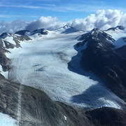
South Cascade Glacier is located in the midlatitude maritime climate of the North Cascade Mountains of Washington State. Glacier observations began at this site in 1958.
South Cascade Glacier located in a north-northwest facing valley near the crest of the Cascade Range in northwest Washington state. Dominated by a maritime climate, the glacier receives heavy annual precipitation, exceeding 4.5 m in places (PRISM Climate Group, 2006) and is heavily influenced by climate conditions in the Pacific Ocean (Walters and Meier, 1989). In 2015, South Cascade glacier had an area of 1.8 km2 in the 6.14 km2 South South Cascade Lake Basin (O'Neel et al, 2019). The glacier spans nearly 660 m in elevation in the steep sided basin which forms the headwaters of the South Fork of the Cascade River.
In 1959 scientists with the USGS began collecting mass balance data on South Cascade Glacier, one of four "benchmark glaciers" in the US. R Repeated point measurements at established index sites, in conjunction with local meteorology and runoff data, are used to estimate glacier-wide mass balances. These data constitute the longest continuous set of mass-balance data in North America (Josberger and others, 2007) which are used to understand glacier dynamics and hydrology, and to measure the glacier's response to climate change.
In 1959 the USGS began a suite of continuous mass balance measurements at South Cascade Glacier, one of four benchmark glaciers in North America. Extensive glaciological measurements within the basin include: streamflow runoff, precipitation, air temperature, barometric pressure, snow thickness and density, ice ablation, surface speed, and surface altitude. Multiple site visits are made annually for facility maintenance, instrument repair and installation, and direct measurement of snow and ice. There are six stakes dispersed along a center transect from the terminus to the head of the glacier where measurements of ice ablation, and snow depth and density are repeated annually.
Direct field measurements are combined with weather data and imagery analyses to calculate the seasonal and annual mass balance of each glacier. Access all the data here.
Meteorologic
Meteorological observations began in 1959 with installation of temperature and precipitation instruments at several locations in the basin. At the Salix Creek and Middle Tarn gaging station air temperature is measured with thermistor-based sensors in passively ventilated radiation shields, between 3-3.5 m above the ground. At the Hut, air temperature, wind speed, and incoming solar radiation are measured about 1.5 m above the roof.
Air temperature at a constant height of 2.0 m above the glacier surface has also been collected during summer months for a portion of the period of record at South Cascade Glacier.
Liquid precipitation is measured by means of tipping bucket rain gage at Salix and Middle Tarn gaging stations. These unheated gages do not account for precipitation in the form of snow so the record of precipitation at both sites is limited to summer catch.
Scientists collecting data on South Cascade Glacier, Washington State.
Temperature, air
Wind direction
Wind speed
Precipitation
Solar Radiation
Hydrologic
Runoff from Middle Tarn basin was computed from discharge of the South Fork of the Cascade River where it empties from Middle Tarn. Details of calculations and determination of rating curves can be found in USGS summaries of balance years.
Previous Work
South Cascade glacier, the site of one of North America's longest glacier mass balance records, has been the focus of many facets of glacier research over the years. The world's first radio-echo sounding measurements in temperate ice were conducted on South Cascade Glacier and subglacial water flow have been studied on this glacier, among various other studies aimed at advancing the understanding glaciers. Past data and observations of snow and ice changes on South Cascade Glacier can be found in the collection of USGS Scanned Field Notebooks from South Cascade Glacier, Washington, 1957 - 2022.
Mountain glaciers are dynamic reservoirs of frozen water, deeply interconnected with their surrounding ecosystems. Glacier change in North America has major societal impacts, including to water resources, natural hazard risk, tourism disruption, fisheries, and global sea level change. Understanding and quantifying precise connections between changing glaciers, the surrounding landscape and climate...
Mountain glaciers are dynamic reservoirs of frozen water, deeply interconnected with their surrounding ecosystems. Glacier change in North America has major societal impacts, including to water resources, natural hazard risk, tourism disruption, fisheries, and global sea level change. Understanding and quantifying precise connections between changing glaciers, the surrounding landscape and climate...
Nearly all of Earth's alpine glaciers are losing mass, with consequences for freshwater resources, landscape stability, regional ecosystems, and global sea level. Rates of glacier mass loss in Western North America and Alaska are among the highest on Earth (The GlaMBIE Team, 2025).
Nearly all of Earth's alpine glaciers are losing mass, with consequences for freshwater resources, landscape stability, regional ecosystems, and global sea level. Rates of glacier mass loss in Western North America and Alaska are among the highest on Earth (The GlaMBIE Team, 2025).
The USGS Glacier Project has conducted research beyond the Benchmark Glaciers, both past and present. This work has focused on infrastructure hazards, rapid glacier change, landscape destabilization, and glacier dynamics and processes not captured by the Benchmark Glacier network. These glaciers include Black Rapids, Kahiltna, Kennicott, Columbia, Hubbard, and Taku.
The USGS Glacier Project has conducted research beyond the Benchmark Glaciers, both past and present. This work has focused on infrastructure hazards, rapid glacier change, landscape destabilization, and glacier dynamics and processes not captured by the Benchmark Glacier network. These glaciers include Black Rapids, Kahiltna, Kennicott, Columbia, Hubbard, and Taku.
Wolverine Glacier is located in the high-latitude maritime climate regime of Alaska’s Kenai Mountains. Glacier observations began at this site in 1966.
Wolverine Glacier is located in the high-latitude maritime climate regime of Alaska’s Kenai Mountains. Glacier observations began at this site in 1966.
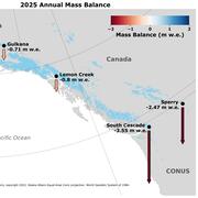
Gulkana Glacier is located in the high-latitude continental climate regime of Alaska’s Delta Mountains. Glacier observations began at this site in 1966 and continue through present as the northern most USGS Benchmark Glacier.
Gulkana Glacier is located in the high-latitude continental climate regime of Alaska’s Delta Mountains. Glacier observations began at this site in 1966 and continue through present as the northern most USGS Benchmark Glacier.
Lemon Creek Glacier is located in the high-latitude maritime region of Alaska, at the southernmost tip of the Juneau Icefield. Glacier observations began at this site in 1953.
Lemon Creek Glacier is located in the high-latitude maritime region of Alaska, at the southernmost tip of the Juneau Icefield. Glacier observations began at this site in 1953.
Sperry Glacier is located along the Continental Divide within Glacier National Park, Montana. It represents the midlatitude continental or transitional climate. Glacier observations began at this site in 2005.
Sperry Glacier is located along the Continental Divide within Glacier National Park, Montana. It represents the midlatitude continental or transitional climate. Glacier observations began at this site in 2005.
South Cascade Glacier, northwestern Washington State
South Cascade Glacier, northwestern Washington State. South Cascade Glacier located in a north-northwest facing valley near the crest of the Cascade Range in northwest Washington state. In 1959 scientists with the USGS began collecting mass balance data on South Cascade Glacier, now one of five "benchmark glaciers" in the US.
South Cascade Glacier, northwestern Washington State. South Cascade Glacier located in a north-northwest facing valley near the crest of the Cascade Range in northwest Washington state. In 1959 scientists with the USGS began collecting mass balance data on South Cascade Glacier, now one of five "benchmark glaciers" in the US.
Scientist collecting samples on South Cascade Glacier
Scientist collection samples on South Cascade Glacier, northwestern Washington State. South Cascade Glacier located in a north-northwest facing valley near the crest of the Cascade Range in northwest Washington state. In 1959 scientists with the USGS began collecting mass balance data on South Cascade Glacier, now one of five "benchmark glaciers" in the US.
Scientist collection samples on South Cascade Glacier, northwestern Washington State. South Cascade Glacier located in a north-northwest facing valley near the crest of the Cascade Range in northwest Washington state. In 1959 scientists with the USGS began collecting mass balance data on South Cascade Glacier, now one of five "benchmark glaciers" in the US.
Scientists collecting data on South Cascade Glacier, Washington State
Scientists collecting data on South Cascade Glacier, Washington State. South Cascade Glacier is located in a north-northwest facing valley near the crest of the Cascade Range in northwest Washington state. In 1959 scientists with the USGS began collecting mass balance data on South Cascade Glacier, now one of five "benchmark glaciers" in the US.
Scientists collecting data on South Cascade Glacier, Washington State. South Cascade Glacier is located in a north-northwest facing valley near the crest of the Cascade Range in northwest Washington state. In 1959 scientists with the USGS began collecting mass balance data on South Cascade Glacier, now one of five "benchmark glaciers" in the US.
Glaciers are important drivers of environmental heterogeneity and biological diversity across mountain landscapes. Worldwide, glaciers are receding rapidly due to climate change, with important consequences for biodiversity in mountain ecosystems. However, the effects of glacier loss on biodiversity have never been quantified across a mountainous region, primarily due to a lack of...
Authors
Clint C. Muhlfeld, Timothy Joseph Cline, J. Joseph Giersch, Erich H. Peitzsch, Caitlyn Florentine, Dean Jacobsen, Scott Hotaling
Glaciers are a key indicator of changing climate in the high mountain landscape. Glacier variations across a mountain range are ultimately driven by regional climate forcing. However, changes also reflect local, topographically driven processes such as snow avalanching, snow wind-drifting, and radiation shading as well as the initial glacier conditions such as hypsometry and ice...
Authors
Caitlyn Elizabeth Florentine, Joel T. Harper, Daniel B. Fagre
We reanalyzed mass balance records at Taku and Lemon Creek Glaciers to better understand the relative roles of hypsometry, local climate and dynamics as mass balance drivers. Over the 1946–2018 period, the cumulative mass balances diverged. Tidewater Taku Glacier advanced and gained mass at an average rate of +0.25±0.28 m w.e. a–1, contrasting with retreat and mass loss of –0.60±0.15 m w...
Authors
Christopher J. McNeil, Shad O’Neel, Michael Loso, Mauri Pelto, Louis C. Sass, Emily Baker, Seth Campbell
Currently, the volume of land ice on Earth is decreasing, driving consequential changes to global sea level and local stream habitat. Glacier retreat in Glacier National Park, Montana, U.S.A., is one example of land ice loss and glacier change. The U.S. Geological Survey Benchmark Glacier Project conducts glaciological research and collects field measurements across select North American...
Mountain glaciers integrate climate processes to provide an unmatched signal of regional climate forcing. However, extracting the climate signal via intercomparison of regional glacier mass balance records can be problematic when methods for extrapolating and calibrating direct glaciological measurements are mixed or inconsistent. To address this problem, we reanalyzed and compared long...
Authors
Shad O’Neel, Christopher J. McNeil, Louis C. Sass, Caitlyn Florentine, Emily Baker, Erich H. Peitzsch, Daniel McGrath, Andrew G. Fountain, Daniel B. Fagre
Glacial ice is a significant influence on local climate, hydrology, vegetation, and wildlife. We mapped a complete set of glacier areas from the Little Ice Age (LIA) using very high-resolution satellite imagery (30-cm) within Glacier National Park, a region that encompasses over 400,000 hectares. We measured glacier change across the park using LIA glacier area as a baseline and used...
There is significant uncertainty regarding the spatiotemporal distribution of seasonal snow on glaciers, despite being a fundamental component of glacier mass balance. To address this knowledge gap, we collected repeat, spatially extensive high-frequency ground-penetrating radar (GPR) observations on two glaciers in Alaska for five consecutive years. GPR measurements showed steep snow...
Authors
Daniel McGrath, Louis Sass, Shad O’Neel, Christopher J. McNeil, Salvatore G Candela, Emily Baker, Hans P. Marshall
Local topographically driven processes – such as wind drifting, avalanching, and shading – are known to alter the relationship between the mass balance of small cirque glaciers and regional climate. Yet partitioning such local effects from regional climate influence has proven difficult, creating uncertainty in the climate representativeness of some glaciers. We address this problem for...
Authors
Caitlyn Florentine, Joel T. Harper, Daniel B. Fagre, Johnnie Moore, Erich H. Peitzsch
Arctic river discharge has increased in recent decades although sources and mechanisms remain debated. Abundant literature documents permafrost thaw and mountain glacier shrinkage over the past decades. Here we link glacier runoff to aquifer recharge via a losing headwater stream in subarctic Interior Alaska. Field measurements in Jarvis Creek (634 km2), a subbasin of the Tanana and...
Authors
Anna K. Lilledahl, Anne Gadeke, Shad O’Neel, T. A. Gatesman, T. A. Douglas
Temperature and precipitation are key determinants of snowpack levels. Therefore, climate change is likely to affect the role of snow and ice in the landscapes and hydrology of the Chugach National Forest region. Downscaled climate projections developed by Scenarios Network for Alaska and Arctic Planning (SNAP) are useful for examining projected changes in snow at relatively fine...
Authors
Jeremy S. Littell, Stephanie A. McAfee, Shad O’Neel, Louis C. Sass, Evan Burgess, Steve Colt, Paul Clark
We analyzed glacier surface elevations (1957, 2010 and 2015) and surface mass-balance measurements (2008–2015) on the 30 km2 Eklutna Glacier, in the Chugach Mountains of southcentral Alaska. The geodetic mass balances from 1957 to 2010 and 2010 to 2015 are −0.52 ± 0.46 and −0.74 ± 0.10 m w.e. a−1, respectively. The glaciological mass balance of −0.73 m w.e. a−1 from 2010 to 2015 is
Authors
Louis C. Sass, Michael G. Loso, Jason Geck, Evan Thoms, Daniel Mcgrath
Glacier hypsometry provides a first‐order approach for assessing a glacier's response to climate forcings. We couple the Randolph Glacier Inventory to a suite of in situ observations and climate model output to examine potential change for the ∼27,000 glaciers in Alaska and northwest Canada through the end of the 21st century. By 2100, based on Representative Concentration Pathways (RCPs...
Authors
Daniel Mcgrath, Louis C. Sass, Shad O’Neel, Anthony A. Arendt, C. Kienholz
South Cascade Glacier is located in the midlatitude maritime climate of the North Cascade Mountains of Washington State. Glacier observations began at this site in 1958.
South Cascade Glacier located in a north-northwest facing valley near the crest of the Cascade Range in northwest Washington state. Dominated by a maritime climate, the glacier receives heavy annual precipitation, exceeding 4.5 m in places (PRISM Climate Group, 2006) and is heavily influenced by climate conditions in the Pacific Ocean (Walters and Meier, 1989). In 2015, South Cascade glacier had an area of 1.8 km2 in the 6.14 km2 South South Cascade Lake Basin (O'Neel et al, 2019). The glacier spans nearly 660 m in elevation in the steep sided basin which forms the headwaters of the South Fork of the Cascade River.
In 1959 scientists with the USGS began collecting mass balance data on South Cascade Glacier, one of four "benchmark glaciers" in the US. R Repeated point measurements at established index sites, in conjunction with local meteorology and runoff data, are used to estimate glacier-wide mass balances. These data constitute the longest continuous set of mass-balance data in North America (Josberger and others, 2007) which are used to understand glacier dynamics and hydrology, and to measure the glacier's response to climate change.
In 1959 the USGS began a suite of continuous mass balance measurements at South Cascade Glacier, one of four benchmark glaciers in North America. Extensive glaciological measurements within the basin include: streamflow runoff, precipitation, air temperature, barometric pressure, snow thickness and density, ice ablation, surface speed, and surface altitude. Multiple site visits are made annually for facility maintenance, instrument repair and installation, and direct measurement of snow and ice. There are six stakes dispersed along a center transect from the terminus to the head of the glacier where measurements of ice ablation, and snow depth and density are repeated annually.
Direct field measurements are combined with weather data and imagery analyses to calculate the seasonal and annual mass balance of each glacier. Access all the data here.
Meteorologic
Meteorological observations began in 1959 with installation of temperature and precipitation instruments at several locations in the basin. At the Salix Creek and Middle Tarn gaging station air temperature is measured with thermistor-based sensors in passively ventilated radiation shields, between 3-3.5 m above the ground. At the Hut, air temperature, wind speed, and incoming solar radiation are measured about 1.5 m above the roof.
Air temperature at a constant height of 2.0 m above the glacier surface has also been collected during summer months for a portion of the period of record at South Cascade Glacier.
Liquid precipitation is measured by means of tipping bucket rain gage at Salix and Middle Tarn gaging stations. These unheated gages do not account for precipitation in the form of snow so the record of precipitation at both sites is limited to summer catch.
Scientists collecting data on South Cascade Glacier, Washington State.
Temperature, air
Wind direction
Wind speed
Precipitation
Solar Radiation
Hydrologic
Runoff from Middle Tarn basin was computed from discharge of the South Fork of the Cascade River where it empties from Middle Tarn. Details of calculations and determination of rating curves can be found in USGS summaries of balance years.
Previous Work
South Cascade glacier, the site of one of North America's longest glacier mass balance records, has been the focus of many facets of glacier research over the years. The world's first radio-echo sounding measurements in temperate ice were conducted on South Cascade Glacier and subglacial water flow have been studied on this glacier, among various other studies aimed at advancing the understanding glaciers. Past data and observations of snow and ice changes on South Cascade Glacier can be found in the collection of USGS Scanned Field Notebooks from South Cascade Glacier, Washington, 1957 - 2022.
Mountain glaciers are dynamic reservoirs of frozen water, deeply interconnected with their surrounding ecosystems. Glacier change in North America has major societal impacts, including to water resources, natural hazard risk, tourism disruption, fisheries, and global sea level change. Understanding and quantifying precise connections between changing glaciers, the surrounding landscape and climate...
Mountain glaciers are dynamic reservoirs of frozen water, deeply interconnected with their surrounding ecosystems. Glacier change in North America has major societal impacts, including to water resources, natural hazard risk, tourism disruption, fisheries, and global sea level change. Understanding and quantifying precise connections between changing glaciers, the surrounding landscape and climate...
Nearly all of Earth's alpine glaciers are losing mass, with consequences for freshwater resources, landscape stability, regional ecosystems, and global sea level. Rates of glacier mass loss in Western North America and Alaska are among the highest on Earth (The GlaMBIE Team, 2025).
Nearly all of Earth's alpine glaciers are losing mass, with consequences for freshwater resources, landscape stability, regional ecosystems, and global sea level. Rates of glacier mass loss in Western North America and Alaska are among the highest on Earth (The GlaMBIE Team, 2025).
The USGS Glacier Project has conducted research beyond the Benchmark Glaciers, both past and present. This work has focused on infrastructure hazards, rapid glacier change, landscape destabilization, and glacier dynamics and processes not captured by the Benchmark Glacier network. These glaciers include Black Rapids, Kahiltna, Kennicott, Columbia, Hubbard, and Taku.
The USGS Glacier Project has conducted research beyond the Benchmark Glaciers, both past and present. This work has focused on infrastructure hazards, rapid glacier change, landscape destabilization, and glacier dynamics and processes not captured by the Benchmark Glacier network. These glaciers include Black Rapids, Kahiltna, Kennicott, Columbia, Hubbard, and Taku.
Wolverine Glacier is located in the high-latitude maritime climate regime of Alaska’s Kenai Mountains. Glacier observations began at this site in 1966.
Wolverine Glacier is located in the high-latitude maritime climate regime of Alaska’s Kenai Mountains. Glacier observations began at this site in 1966.
Gulkana Glacier is located in the high-latitude continental climate regime of Alaska’s Delta Mountains. Glacier observations began at this site in 1966 and continue through present as the northern most USGS Benchmark Glacier.
Gulkana Glacier is located in the high-latitude continental climate regime of Alaska’s Delta Mountains. Glacier observations began at this site in 1966 and continue through present as the northern most USGS Benchmark Glacier.
Lemon Creek Glacier is located in the high-latitude maritime region of Alaska, at the southernmost tip of the Juneau Icefield. Glacier observations began at this site in 1953.
Lemon Creek Glacier is located in the high-latitude maritime region of Alaska, at the southernmost tip of the Juneau Icefield. Glacier observations began at this site in 1953.
Sperry Glacier is located along the Continental Divide within Glacier National Park, Montana. It represents the midlatitude continental or transitional climate. Glacier observations began at this site in 2005.
Sperry Glacier is located along the Continental Divide within Glacier National Park, Montana. It represents the midlatitude continental or transitional climate. Glacier observations began at this site in 2005.
South Cascade Glacier, northwestern Washington State
South Cascade Glacier, northwestern Washington State. South Cascade Glacier located in a north-northwest facing valley near the crest of the Cascade Range in northwest Washington state. In 1959 scientists with the USGS began collecting mass balance data on South Cascade Glacier, now one of five "benchmark glaciers" in the US.
South Cascade Glacier, northwestern Washington State. South Cascade Glacier located in a north-northwest facing valley near the crest of the Cascade Range in northwest Washington state. In 1959 scientists with the USGS began collecting mass balance data on South Cascade Glacier, now one of five "benchmark glaciers" in the US.
Scientist collecting samples on South Cascade Glacier
Scientist collection samples on South Cascade Glacier, northwestern Washington State. South Cascade Glacier located in a north-northwest facing valley near the crest of the Cascade Range in northwest Washington state. In 1959 scientists with the USGS began collecting mass balance data on South Cascade Glacier, now one of five "benchmark glaciers" in the US.
Scientist collection samples on South Cascade Glacier, northwestern Washington State. South Cascade Glacier located in a north-northwest facing valley near the crest of the Cascade Range in northwest Washington state. In 1959 scientists with the USGS began collecting mass balance data on South Cascade Glacier, now one of five "benchmark glaciers" in the US.
Scientists collecting data on South Cascade Glacier, Washington State
Scientists collecting data on South Cascade Glacier, Washington State. South Cascade Glacier is located in a north-northwest facing valley near the crest of the Cascade Range in northwest Washington state. In 1959 scientists with the USGS began collecting mass balance data on South Cascade Glacier, now one of five "benchmark glaciers" in the US.
Scientists collecting data on South Cascade Glacier, Washington State. South Cascade Glacier is located in a north-northwest facing valley near the crest of the Cascade Range in northwest Washington state. In 1959 scientists with the USGS began collecting mass balance data on South Cascade Glacier, now one of five "benchmark glaciers" in the US.
Glaciers are important drivers of environmental heterogeneity and biological diversity across mountain landscapes. Worldwide, glaciers are receding rapidly due to climate change, with important consequences for biodiversity in mountain ecosystems. However, the effects of glacier loss on biodiversity have never been quantified across a mountainous region, primarily due to a lack of...
Authors
Clint C. Muhlfeld, Timothy Joseph Cline, J. Joseph Giersch, Erich H. Peitzsch, Caitlyn Florentine, Dean Jacobsen, Scott Hotaling
Glaciers are a key indicator of changing climate in the high mountain landscape. Glacier variations across a mountain range are ultimately driven by regional climate forcing. However, changes also reflect local, topographically driven processes such as snow avalanching, snow wind-drifting, and radiation shading as well as the initial glacier conditions such as hypsometry and ice...
Authors
Caitlyn Elizabeth Florentine, Joel T. Harper, Daniel B. Fagre
We reanalyzed mass balance records at Taku and Lemon Creek Glaciers to better understand the relative roles of hypsometry, local climate and dynamics as mass balance drivers. Over the 1946–2018 period, the cumulative mass balances diverged. Tidewater Taku Glacier advanced and gained mass at an average rate of +0.25±0.28 m w.e. a–1, contrasting with retreat and mass loss of –0.60±0.15 m w...
Authors
Christopher J. McNeil, Shad O’Neel, Michael Loso, Mauri Pelto, Louis C. Sass, Emily Baker, Seth Campbell
Currently, the volume of land ice on Earth is decreasing, driving consequential changes to global sea level and local stream habitat. Glacier retreat in Glacier National Park, Montana, U.S.A., is one example of land ice loss and glacier change. The U.S. Geological Survey Benchmark Glacier Project conducts glaciological research and collects field measurements across select North American...
Mountain glaciers integrate climate processes to provide an unmatched signal of regional climate forcing. However, extracting the climate signal via intercomparison of regional glacier mass balance records can be problematic when methods for extrapolating and calibrating direct glaciological measurements are mixed or inconsistent. To address this problem, we reanalyzed and compared long...
Authors
Shad O’Neel, Christopher J. McNeil, Louis C. Sass, Caitlyn Florentine, Emily Baker, Erich H. Peitzsch, Daniel McGrath, Andrew G. Fountain, Daniel B. Fagre
Glacial ice is a significant influence on local climate, hydrology, vegetation, and wildlife. We mapped a complete set of glacier areas from the Little Ice Age (LIA) using very high-resolution satellite imagery (30-cm) within Glacier National Park, a region that encompasses over 400,000 hectares. We measured glacier change across the park using LIA glacier area as a baseline and used...
There is significant uncertainty regarding the spatiotemporal distribution of seasonal snow on glaciers, despite being a fundamental component of glacier mass balance. To address this knowledge gap, we collected repeat, spatially extensive high-frequency ground-penetrating radar (GPR) observations on two glaciers in Alaska for five consecutive years. GPR measurements showed steep snow...
Authors
Daniel McGrath, Louis Sass, Shad O’Neel, Christopher J. McNeil, Salvatore G Candela, Emily Baker, Hans P. Marshall
Local topographically driven processes – such as wind drifting, avalanching, and shading – are known to alter the relationship between the mass balance of small cirque glaciers and regional climate. Yet partitioning such local effects from regional climate influence has proven difficult, creating uncertainty in the climate representativeness of some glaciers. We address this problem for...
Authors
Caitlyn Florentine, Joel T. Harper, Daniel B. Fagre, Johnnie Moore, Erich H. Peitzsch
Arctic river discharge has increased in recent decades although sources and mechanisms remain debated. Abundant literature documents permafrost thaw and mountain glacier shrinkage over the past decades. Here we link glacier runoff to aquifer recharge via a losing headwater stream in subarctic Interior Alaska. Field measurements in Jarvis Creek (634 km2), a subbasin of the Tanana and...
Authors
Anna K. Lilledahl, Anne Gadeke, Shad O’Neel, T. A. Gatesman, T. A. Douglas
Temperature and precipitation are key determinants of snowpack levels. Therefore, climate change is likely to affect the role of snow and ice in the landscapes and hydrology of the Chugach National Forest region. Downscaled climate projections developed by Scenarios Network for Alaska and Arctic Planning (SNAP) are useful for examining projected changes in snow at relatively fine...
Authors
Jeremy S. Littell, Stephanie A. McAfee, Shad O’Neel, Louis C. Sass, Evan Burgess, Steve Colt, Paul Clark
We analyzed glacier surface elevations (1957, 2010 and 2015) and surface mass-balance measurements (2008–2015) on the 30 km2 Eklutna Glacier, in the Chugach Mountains of southcentral Alaska. The geodetic mass balances from 1957 to 2010 and 2010 to 2015 are −0.52 ± 0.46 and −0.74 ± 0.10 m w.e. a−1, respectively. The glaciological mass balance of −0.73 m w.e. a−1 from 2010 to 2015 is
Authors
Louis C. Sass, Michael G. Loso, Jason Geck, Evan Thoms, Daniel Mcgrath
Glacier hypsometry provides a first‐order approach for assessing a glacier's response to climate forcings. We couple the Randolph Glacier Inventory to a suite of in situ observations and climate model output to examine potential change for the ∼27,000 glaciers in Alaska and northwest Canada through the end of the 21st century. By 2100, based on Representative Concentration Pathways (RCPs...
Authors
Daniel Mcgrath, Louis C. Sass, Shad O’Neel, Anthony A. Arendt, C. Kienholz