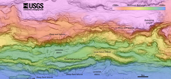
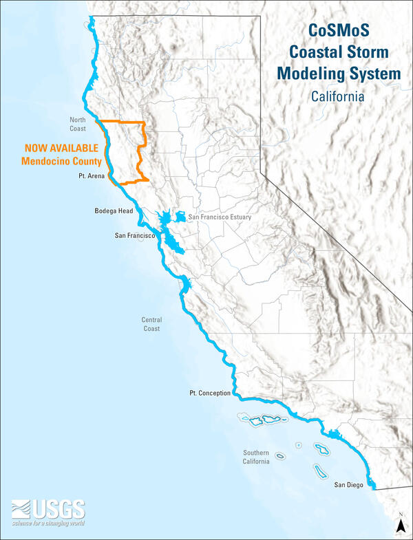
U.S. flag

An official website of the United States government

Images

Coastal and Marine Hazards and Resources Program images.

Filter Total Items: 2398
social media post
Social Media: Shoreline Change of Long Island Sound

A new #datarelease contains a GIS compilation of vector shorelines and associated #shorelinechange data from the 1800s to the 2010s for the coast of Long Island Sound, #NewYork and #Connecticut. 

A new #datarelease contains a GIS compilation of vector shorelines and associated #shorelinechange data from the 1800s to the 2010s for the coast of Long Island Sound, #NewYork and #Connecticut. 

Photos of the autonomous MAPCAT cataraft being tested on a lake
Photos of the autonomous MAPCAT cataraft being tested

The Autonomous MAPping CATaraft, or “Autonomous MAPCAT”, is a remotely controlled, 14 foot long by 7 foot wide boat, built from an inflatable pontoon, aluminum frame, whitewater cataraft.

Collage of images showing natural offshore oil seepage on the California Coastline
two people smiling, equipment in the water behind them
Skilak Lake Seismograph Rescue Mission

ROV pilots Raeylynn Heinz and Alex Wick (both from OSU OOI) celebrate as their ROV and the OBS surface in Skilak Lake.

equipment underwater
Skilak Lake Seismograph Rescue Mission

View from the remotely operated vehicle (ROV) after attaching a recovery line to the ocean bottom seismograph 190 meters deep in Skilak Lake, Alaska.

View from the remotely operated vehicle (ROV) after attaching a recovery line to the ocean bottom seismograph 190 meters deep in Skilak Lake, Alaska.

person standing on sandy beach with control in hand looking at drone in the sky over cliffs
Mapping Gay Head Cliffs

The USGS Aerial Imaging and Mapping Group (AIMG) collaborated with the Wampanoag Tribe of Gay Head (Aquinnah), the Town of Aquinnah, and the Aquinnah Police Department to collect high-resolution data of the Gay Head Cliffs.

The USGS Aerial Imaging and Mapping Group (AIMG) collaborated with the Wampanoag Tribe of Gay Head (Aquinnah), the Town of Aquinnah, and the Aquinnah Police Department to collect high-resolution data of the Gay Head Cliffs.

maps showing 4-year change vs. 10-year change
Aquinnah Time Series

The USGS Aerial Imaging and Mapping Group (AIMG) collaborated with the Wampanoag Tribe of Gay Head (Aquinnah), the Town of Aquinnah, and the Aquinnah Police Department to collect high-resolution data of the Gay Head Cliffs.

The USGS Aerial Imaging and Mapping Group (AIMG) collaborated with the Wampanoag Tribe of Gay Head (Aquinnah), the Town of Aquinnah, and the Aquinnah Police Department to collect high-resolution data of the Gay Head Cliffs.

cliff backed sandy beach with two people walking on the sand
Mapping of Gay Head Cliffs

The USGS Aerial Imaging and Mapping Group (AIMG) collaborated with the Wampanoag Tribe of Gay Head (Aquinnah), the Town of Aquinnah, and the Aquinnah Police Department to collect high-resolution data of the Gay Head Cliffs.

The USGS Aerial Imaging and Mapping Group (AIMG) collaborated with the Wampanoag Tribe of Gay Head (Aquinnah), the Town of Aquinnah, and the Aquinnah Police Department to collect high-resolution data of the Gay Head Cliffs.

aerial group photo of big group outside
Special Visitors at WHCMSC

Woods Hole Coastal and Marine Science Center staff with Dave Applegate (USGS Chief Scientist and Acting Associate Director, USGS Natural Hazards Mission Area), Jonathan Godt (Program Coordinator, USGS Landslide Hazards Program), and Emily Himmelstoss (Associate Program Coordinator for Science, USGS Coastal and Marine Hazards and Resources Program) during a special v

Woods Hole Coastal and Marine Science Center staff with Dave Applegate (USGS Chief Scientist and Acting Associate Director, USGS Natural Hazards Mission Area), Jonathan Godt (Program Coordinator, USGS Landslide Hazards Program), and Emily Himmelstoss (Associate Program Coordinator for Science, USGS Coastal and Marine Hazards and Resources Program) during a special v

Detailed map showing seafloor features such as submarine canyons and slope failures offshore Kodiak Island, Alaska
woman smiling, talking to a man and kid, outside at USGS booth
2025 Woods Hole Science Stroll

Marie Bartlett talking about foraminifera and sediment cores at the Woods Hole Science Stroll.

Person sitting at USGS booth under tent outside, smiling at person visiting the booth
2025 Woods Hole Science Stroll

Marie Bartlett at the 2025 Woods Hole Science Stroll on August 9, 2025. During this free event, a variety of booths line the streets, docks, and Waterfront Park to deliver hands-on science activities, games, demonstrations, and more to visitors of all ages. 

Marie Bartlett at the 2025 Woods Hole Science Stroll on August 9, 2025. During this free event, a variety of booths line the streets, docks, and Waterfront Park to deliver hands-on science activities, games, demonstrations, and more to visitors of all ages. 

USGS scientists talking to visitors at booth under tent outside
2025 Woods Hole Science Stroll

The USGS booth at the 2025 Woods Hole Science Stroll on August 9, 2025. During this free event, a variety of booths line the streets, docks, and Waterfront Park to deliver hands-on science activities, games, demonstrations, and more to visitors of all ages. 

The USGS booth at the 2025 Woods Hole Science Stroll on August 9, 2025. During this free event, a variety of booths line the streets, docks, and Waterfront Park to deliver hands-on science activities, games, demonstrations, and more to visitors of all ages. 

Person in USGS hat and shirt at USGS booth outside smiling at kids playing with our Legos
2025 Woods Hole Science Stroll

Jin-Si Over watching kids enjoy the earthquake station at the 2025 Woods Hole Science Stroll on August 9, 2025. We setup a shake table that moves in different directions, at varying frequencies to demonstrate the power of earthquakes.

Jin-Si Over watching kids enjoy the earthquake station at the 2025 Woods Hole Science Stroll on August 9, 2025. We setup a shake table that moves in different directions, at varying frequencies to demonstrate the power of earthquakes.

Father holding daughter up to look through microscope, while USGS
2025 Woods Hole Science Stroll

Marie Bartlett teaching visitors about foraminifera, tiny microfossils that live in marine environments. Scientists at the USGS use foraminifera to determine the age of sediment found many meters below the seafloor and to learn more about past climate conditions.

Marie Bartlett teaching visitors about foraminifera, tiny microfossils that live in marine environments. Scientists at the USGS use foraminifera to determine the age of sediment found many meters below the seafloor and to learn more about past climate conditions.

a family visiting a USGS booth outside
2025 Woods Hole Science Stroll

Eric Moore setup a shake table that moves in different directions, at varying frequencies to demonstrate the power of earthquakes. People built structures out of Legos to put on the shake table to test how buildings, bridges, and other infrastructure would behave during a real seismic event.

Eric Moore setup a shake table that moves in different directions, at varying frequencies to demonstrate the power of earthquakes. People built structures out of Legos to put on the shake table to test how buildings, bridges, and other infrastructure would behave during a real seismic event.

Person in USGS shirt talking to adult and two kids at USGS booth outside
2025 Woods Hole Science Stroll

Brita Jessen at the 2025 Woods Hole Science Stroll on August 9, 2025. During this free event, a variety of booths line the streets, docks, and Waterfront Park to deliver hands-on science activities, games, demonstrations, and more to visitors of all ages. 

Brita Jessen at the 2025 Woods Hole Science Stroll on August 9, 2025. During this free event, a variety of booths line the streets, docks, and Waterfront Park to deliver hands-on science activities, games, demonstrations, and more to visitors of all ages. 

Person holding drone next to USGS booth and tent outside
2025 Woods Hole Science Stroll

Checking out one of our drones! The Aerial Imaging and Mapping Group showcased uncrewed aircraft system technology (drones) of all sizes and talked about how they’re used to map short- and long-term changes in coastal landscapes. The group also flew one of the drones to demonstrate how they’re piloted.

Checking out one of our drones! The Aerial Imaging and Mapping Group showcased uncrewed aircraft system technology (drones) of all sizes and talked about how they’re used to map short- and long-term changes in coastal landscapes. The group also flew one of the drones to demonstrate how they’re piloted.

person showing equipment to visitor at USGS booth under tent outside
2025 Woods Hole Science Stroll

Meagan Eagle used a gas analyzer and respiration chamber to demonstrate the role of salt marshes in carbon sequestration.

USGS tent and four tables with people visiting the booths to talk to the scientists
2025 Woods Hole Science Stroll

The USGS booth at the 2025 Woods Hole Science Stroll on August 9, 2025. During this free event, a variety of booths line the streets, docks, and Waterfront Park to deliver hands-on science activities, games, demonstrations, and more to visitors of all ages. 

The USGS booth at the 2025 Woods Hole Science Stroll on August 9, 2025. During this free event, a variety of booths line the streets, docks, and Waterfront Park to deliver hands-on science activities, games, demonstrations, and more to visitors of all ages. 

Was this page helpful?