
Storm overwash on Surf Drive Beach, Falmouth, MA
Images
Coastal and Marine Hazards and Resources Program images.
Filter Total Items: 2413

Storm overwash, Surf Drive Beach, Falmouth MA
Storm overwash on Surf Drive Beach, Falmouth, MA

Storm overwash, Surf Drive Beach, Falmouth, MA
Storm overwash, Surf Drive Beach, Falmouth, MA
Storm overwash, Surf Drive Beach, Falmouth, MA

Surf Drive Beach, Falmouth, MA
Overwash from Surf Drive Beach, Falmouth, MA

Storm overwash, Surf Drive Beach, Falmouth, MA
Storm overwash, Surf Drive Beach, Falmouth, MA
Storm overwash, Surf Drive Beach, Falmouth, MA
Mud Creek Topo Change June 13-October 12 2017 View 3
Mud Creek Topo Change June 13-October 12 2017 View 3In 2017, the massive Mud Creek landslide buried a quarter-mile of the famous coastal route, California’s Highway 1, with rocks and dirt more than 65 feet deep. USGS monitors erosion along the landslide-prone cliffs of Big Sur, collecting aerial photos frequently throughout the year.

Mud Creek Topo Change June 13-October 12 2017 View 2
Mud Creek Topo Change June 13-October 12 2017 View 2In 2017, the massive Mud Creek landslide buried a quarter-mile of the famous coastal route, California’s Highway 1, with rocks and dirt more than 65 feet deep. USGS monitors erosion along the landslide-prone cliffs of Big Sur, collecting aerial photos frequently throughout the year.

Mud Creek Topo Change June 13-October 12 2017 View 1
Mud Creek Topo Change June 13-October 12 2017 View 1In 2017, the massive Mud Creek landslide buried a quarter-mile of the famous coastal route, California’s Highway 1, with rocks and dirt more than 65 feet deep. USGS monitors erosion along the landslide-prone cliffs of Big Sur, collecting aerial photos frequently throughout the year.

Drone operations on Big Sur landslide, October 12, 2017
Drone operations on Big Sur landslide, October 12, 2017Josh Logan, a physical scientist at the USGS Pacific Coastal and Marine Science Center in Santa Cruz, California, operates an unmanned aerial system, or UAS, often called a "drone", that is equipped with a video camera.

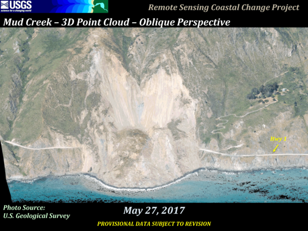
Mud Creek – 3D Point Cloud – Oblique Perspective
Video shot from drones yields details about changing landslide on California’s Big Sur coast
Video shot from drones yields details about changing landslide on California’s Big Sur coast

Earth movers on Big Sur landslide, October 12, 2017
Earth movers on Big Sur landslide, October 12, 2017View of the huge landslide at Mud Creek on the Big Sur coast, October 12, 2017. USGS is studying the landslide, collecting data and imagery that can be used to monitor changes. USGS provides the data to Caltrans, the California Department of Transportation, whose heavy equipment and earth movers are shown here.
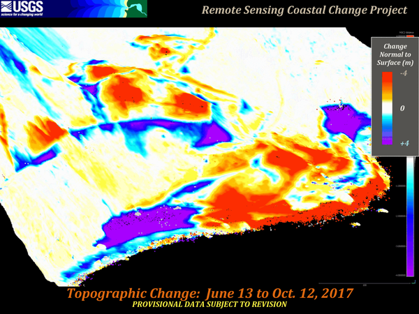
Mud Creek from June 13 to October 12, 2017
In 2017, the massive Mud Creek landslide buried a quarter-mile of the famous coastal route, California’s Highway 1, with rocks and dirt more than 65 feet deep. USGS monitors erosion along the landslide-prone cliffs of Big Sur, collecting aerial photos frequently throughout the year.
In 2017, the massive Mud Creek landslide buried a quarter-mile of the famous coastal route, California’s Highway 1, with rocks and dirt more than 65 feet deep. USGS monitors erosion along the landslide-prone cliffs of Big Sur, collecting aerial photos frequently throughout the year.

Deploying equipment from small boat
Wayne Baldwin, USGS, deploys a sound velocity profiler off the stern of the R/V Stephens in Lake Powell, UT-AZ as part of a collaborative program with the Utah Water Science Center to map the depth and sediments within Lake Powell, UT-AZ.
Wayne Baldwin, USGS, deploys a sound velocity profiler off the stern of the R/V Stephens in Lake Powell, UT-AZ as part of a collaborative program with the Utah Water Science Center to map the depth and sediments within Lake Powell, UT-AZ.

High tide along the marsh shoreline in Middle Bay
Marsh shoreline inundation during high tide at a marsh sampling site around Middle Bay in the Grand Bay National Estuarine Research Reserve, Mississippi.
Marsh shoreline inundation during high tide at a marsh sampling site around Middle Bay in the Grand Bay National Estuarine Research Reserve, Mississippi.

High tide along the marsh shoreline in Middle Bay
Marsh shoreline inundation during high tide north of a marsh sampling site around Middle Bay in the Grand Bay National Estuarine Research Reserve, Mississippi.
Marsh shoreline inundation during high tide north of a marsh sampling site around Middle Bay in the Grand Bay National Estuarine Research Reserve, Mississippi.

Bayou Heron boat ramp at sunrise in Grand Bay, Mississippi
Bayou Heron boat ramp at sunrise in Grand Bay, MississippiPhotograph of a purple sunrise at Bayou Heron boat ramp in the Grand Bay National Estuarine Research Reserve, Mississippi.
Bayou Heron boat ramp at sunrise in Grand Bay, Mississippi
Bayou Heron boat ramp at sunrise in Grand Bay, MississippiPhotograph of a purple sunrise at Bayou Heron boat ramp in the Grand Bay National Estuarine Research Reserve, Mississippi.
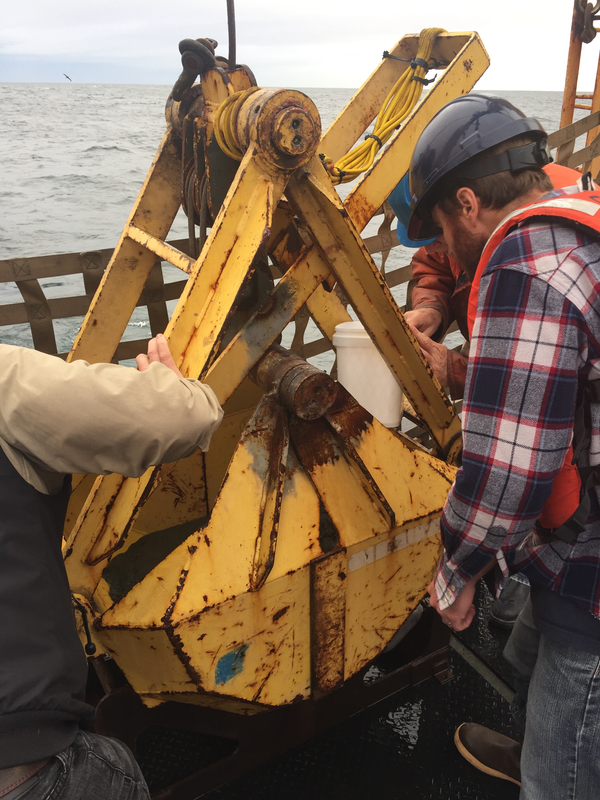
Examining bucket of seafloor sediment collected off southeast Alaska
Examining bucket of seafloor sediment collected off southeast AlaskaUSGS research geophysicist Danny Brothers (right) and colleagues examine the surface of a sediment grab sample just pulled onto the deck of the Canadian Coast Guard Ship John P. Tully. The sample was collected from the top of a mud volcano north of the border between southeast Alaska and British Columbia.

Collecting a piston core of seafloor sediment off British Columbia
Collecting a piston core of seafloor sediment off British ColumbiaScientists prepare to lower a piston corer off Haida Gwaii, British Columbia, to sample seafloor sediment near the Queen Charlotte-Fairweather fault. Expedition scientists are studying layers of sediment in the cores they collected to identify and determine ages of past earthquakes along the fault.

Sampling core fluid from sediment cores collected off southeast Alaska
Sampling core fluid from sediment cores collected off southeast AlaskaMary McGann (left, USGS) and Rachel Lauer (University of Calgary) sample pore fluids from sediment cores collected aboard the Canadian Coast Guard Ship John P. Tully along the Queen Charlotte-Fairweather fault offshore of southeast Alaska.

USGS geologist Carol Reiss examining hydrothermal vent sample
USGS geologist Carol Reiss examining hydrothermal vent sampleUSGS geologist Carol Reiss examining hydrothermal vent sample using hand lens. Sulfide-silicate minerals precipitate from 330°C mineral laden water venting along volcanically active spreading ridges.

USGS scientist Carol Reiss holding a hydrothermal vent sample
USGS scientist Carol Reiss holding a hydrothermal vent sampleUSGS scientist Carol Reiss holding a hydrothermal vent sample. The poster in the background is a scientific rendering by Véronique Robigou (then at University of Washington) of a hydrothermal vent deposit with the submersible Alvin drawn to scale.

Skagit Bay bathymetry
Skagit Bay bathymetry