
Sagebrush Ecosystems
Sagebrush Ecosystems
Filter Total Items: 70

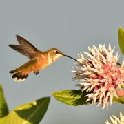
Synthesis of sage-grouse genetic information to support conservation and land management actions
Sage-grouse, iconic birds of the American West, have experienced dramatic reductions and fragmentation of habitat, resulting in significant conservation concern. Genetic information can help inform priorities for protection and habitat restoration as well as strategies for translocations, but may be difficult for resource managers to find, interpret, and use in their decision making. In this work...
KWIC Science: Rapid response products to meet resource managers’ priority science needs
Federal public land managers in the US are required by law to use science to inform management decisions. However, managers have limited time to identify science for use in decision making. Literature reviews are one tool to efficiently summarize science for use by managers, but are time-consuming to produce. Keyword in Context (KWIC) text analysis is a straightforward method of locating specific...

New Tools for Modern Land Management Decisions
In an era of rapid land use changes, it is imperative that land managers and policymakers have actionable and current information available for decision processes. In this work, we seek to meet these needs through new data products and decision support tools built on digital soil mapping, new vegetation cover maps, agency inventory and monitoring data sets, and cutting-edge analytical frameworks...
Wildlife Ecology and Habitat Restoration Team
Our team conducts research on wildlife species ecology, threats to species, causes of population dynamics, and ways to mitigate threats for species recovery. For example, we conduct research on ecological restoration in terrestrial and aquatic environments, and investigate wildlife responses to restoration. We also evaluate standardized methods used to monitor post-restoration outcomes and develop...
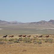
Science for management of America’s iconic wild horses and burros
Wild horses and burros are iconic wildlife of the western USA as well as a complicated management issue on tribal, state, and federal lands. Due to their history as domesticated animals, these wild equids – also called “free-roaming” or “feral” equids – can reproduce quickly, and have few natural predators, allowing their populations to grow rapidly if not managed. When populations are too large...

Greater Sage-Grouse Population Monitoring Framework: Cheat Sheet
The Greater Sage-grouse Population Monitoring Framework fills a prominent information gap to help inform current assessments of sage-grouse population trends at nested spatial and temporal scales. It is centered on four objectives: (1) create a standardized database of lek counts; (2) develop biologically based spatial population structures by clustering leks; (3) estimate spatial trends at...

Greater Sage-Grouse Population Monitoring Framework: Targeted Annual Warning System Information Sheet
The Greater Sage-grouse Population Monitoring Framework helps fill a major information gap to aid current assessments of sage-grouse population trends across spatial and temporal scales. It centers on four objectives: 1) create a standardized database of lek counts; 2) cluster leks to develop spatial population structures; 3) estimate spatial trends across temporal extents; and 4) develop a system...

Greater Sage-Grouse Population Monitoring Framework
Greater sage-grouse ( Centrocercus urophasianus) are at the center of state and national land use policies largely because of their unique life-history traits and their role as an ecological indicator for the health of sagebrush ecosystems. Multiple science centers with the U.S. Geological Survey (USGS) in conjunction with Colorado State University (CSU) have developed the Greater Sage-Grouse...

A user-friendly decision support tool for monitoring and managing greater sage-grouse populations
Researchers at the U.S. Geological Survey (USGS) and Colorado State University (CSU) collaborated with the Bureau of Land Management and state wildlife agencies to develop a hierarchical population monitoring framework for managing greater sage-grouse ( Centrocercus urophasianus) populations and the sagebrush ecosystems they depend on for survival and reproduction. This greater sage-grouse...

A targeted annual warning system (TAWS) for identifying aberrant declines in greater sage-grouse populations
Land and wildlife managers require accurate estimates of sensitive species’ trends to help guide conservation decisions that maintain biodiversity and promote healthy ecosystems. Multiple science centers with the U.S. Geological Survey (USGS), in conjunction with Colorado State University (CSU), developed a hierarchical population monitoring framework for managing greater sage-grouse (...

USGS Sagebrush Science: Supporting Public Safety and Economic Decision Making Across the West
The sagebrush biome is one of the largest ecosystems in North America. Encompassing nearly one-third of the continental U.S., it provides critical resources for millions of Americans and a home for hundreds of plants and animal species in the West. Natural resource management in sagebrush ecosystems can be complex, and science can support management decisions by providing knowledge and tools to...
By
Core Science Systems Mission Area, Ecosystems Mission Area, Biological Threats and Invasive Species Research Program, Climate Adaptation Science Centers, Cooperative Research Units, Land Management Research Program, Species Management Research Program, Earth Resources Observation and Science (EROS) Center, Forest and Rangeland Ecosystem Science Center, Fort Collins Science Center, Northern Rocky Mountain Science Center, Southwest Biological Science Center, Western Ecological Research Center (WERC), Wildland Fire Science

Wyoming Landscape Conservation Initiative (WLCI) research at NOROCK
The Wyoming Landscape Conservation Initiative (WLCI) addresses the impacts of land-use and habitat changes on Southwest Wyoming’s natural resources. This long-term project involves partners from 12 Federal, State, and local natural resource agencies, as well as non-governmental organizations. NOROCK scientists, partners, and scientists from other USGS centers conduct integrated research to support...