
Landslide Event Response Data
Below are the links to the data releases produced by the USGS landslide response team.
2026 Venezuela Sequence Earthquake-Triggered Landslide Hazards: event page
2026 Clay Banks landslide near Deming, WA
2025 M7.0 Hubbard Glacier Earthquake-Triggered Landslides and Snow Avalanches: event page
- Co-polarized Synthetic Aperture Radar (SAR) Change Map between 11/28/2025 and 12/09/2025, Hubbard Glacier Earthquake
- Preliminary Locations of Landslides and Snow Avalanches Triggered by the 2025 M7.0 Hubbard Glacier Earthquake
2025 Hurricane Melissa Landslide Hazards: event page
- Preliminary Landslide Hazard Estimate Maps—2025 Hurricane Melissa Landslide Emergency Response
- Rapid Imagery Assessment for Hazardous Landslides in Jamaica—2025 Hurricane Melissa Emergency Response
2024 Hurricane Helene Landslide Hazards: event page
- Normalized Difference Vegetation Index (NDVI) Change Map between 9/22/2024 and 10/12/2024, Southern Appalachian Mountains (ver. 1.1, March 2025)
- Oblique Aerial Photographs from October 13 and 17, 2024, of Landslides and Flooding Caused by Hurricane Helene (ver 1.1, March 2025)
- Oblique aerial photography from October 3 to 5, 2024, of landslides caused by Hurricane Helene (ver. 1.1, March 2025)
- Preliminary Landslide Hazard Estimate Maps for the 2024 Hurricane Helene Landslide Emergency Response
- Preliminary Landslide Inventory for Landslides Triggered by Hurricane Helene (September 2024)
- Landslide Point Feature Service
- Dashboard for Landslide Mapping
- Landslide Photo Viewer
Related
Landslide Assessments, Situational Awareness, and Event Response Research (LASER)
Landslide crises can unfold in many ways, but in all cases, responders and the public need information about what happened and what might happen next as soon as possible. The LASER project seeks to provide event-driven information products and assessments for landslide events to help guide decision-making and inform the public. The project also conducts research and development aimed towards...
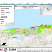
2026 Venezuela Sequence Earthquake-Triggered Landslide Hazards
On Wednesday, June 24th, 2026, a pair of earthquakes of Magnitude 7.2 and Magnitude 7.5 occurred in northern Venezuela, west of Caracas. The U.S. Geological Survey (USGS) Ground Failure product estimated that landslides triggered by this earthquake would likely be significant in number and/or spatial extent. This landslide event page serves to communicate timely science information to our partners...
2025 M7.0 Hubbard Glacier Earthquake-Triggered Landslides and Snow Avalanches
A M7.0 oblique-slip earthquake initiated about 10 km below the Hubbard Glacier in the St. Elias Mountains about 88 km north of Yakutat, Alaska, at approximately 11:40am AKST (1:40pm YST) on December 6, 2025. The U.S. Geological Survey (USGS) Ground Failure product estimated that landslides triggered by this earthquake would likely be significant in number and/or spatial extent. This was confirmed...
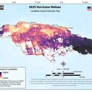
2025 Hurricane Melissa Landslide Hazards
Hurricane Melissa, a category 5 storm, made landfall on October 28, 2025, near the border of Westmoreland and St. Elizabeth Parishes, southwestern Jamaica. The storm brought heavy rainfall, strong winds, and flooding to much of the Caribbean. In Jamaica, intense rainfall on steep mountainous terrain raised concern about potential landslides. This landslide event page serves as an event summary to...
2024 Hurricane Helene Landslide Hazards
Hurricane Helene produced widespread damaging, and in some cases, deadly landslides. Hurricane Helene made landfall in Florida as a Category 4 storm on Thursday, September 26th, 2024. The hurricane continued across the southern Appalachian Mountains producing record rainfall and wind gusts, damaging flooding, and triggering over 2000 landslides. This page provides information about the extent and...
Preliminary Locations of Landslides and Snow Avalanches Triggered by the 2025 M7.0 Hubbard Glacier Earthquake Preliminary Locations of Landslides and Snow Avalanches Triggered by the 2025 M7.0 Hubbard Glacier Earthquake
This data release contains preliminary point locations of potential landslides and snow avalanches triggered by the M7.0 Hubbard Glacier Earthquake based on a Synthetic Aperture Radar (SAR) change map by Eiden (2025). This SAR change map was the first publicly available post-event radar or optical dataset covering the earthquake region. The map reflects changes in the backscattering...
Co-polarized Synthetic Aperture Radar (SAR) Change Map between 11/28/2025 and 12/09/2025, Hubbard Glacier Earthquake Co-polarized Synthetic Aperture Radar (SAR) Change Map between 11/28/2025 and 12/09/2025, Hubbard Glacier Earthquake
This data release contains a radar-based remote sensing product used to detect regions of surface change in southern Yukon Territory, Canada and southeast Alaska, United States between November 28, 2025 and December 9, 2025, based on the availability of Sentinel-1 satellite data. Much of this surface change is interpreted to have been triggered by the M7.0 Hubbard Glacier Earthquake that...
USGS Aerial Photos of Landslides following Hurricane Helene (3-5 October 2024) USGS Aerial Photos of Landslides following Hurricane Helene (3-5 October 2024)
This data release includes aerial photos taken from a small aircraft for reconnaissance purposes (Figure 1). The photos were taken from several different types of cameras ranging from iPhones to Cannon EOS6. Camera attributes can be found in the exif data associated with each file. Photos were taken over a period of 3 days (3-5 October, 2024) to obtain general situational awareness of...
Preliminary Landslide Hazard Estimate Maps for the 2024 Hurricane Helene Landslide Emergency Response Preliminary Landslide Hazard Estimate Maps for the 2024 Hurricane Helene Landslide Emergency Response
This data release includes relative landslide hazard estimate maps for the southern Appalachian Mountains affected by Hurricane Helene (September 26-27, 2024) and the heavy rainfall that preceded it (September 23-26, 2024). The two modeling approaches used were adapted from existing models and were run in early October 2024 using initial precipitation estimates to produce rapid event...
Oblique Aerial Photographs from October 13 and 17, 2024, of Landslides and Flooding Caused by Hurricane Helene (ver 1.1, March 2025) Oblique Aerial Photographs from October 13 and 17, 2024, of Landslides and Flooding Caused by Hurricane Helene (ver 1.1, March 2025)
This data release consists of geotagged oblique aerial photographs taken by U.S. Geological Survey (USGS) scientists to support landslide situational awareness following Hurricane Helene under mission assignment from the Federal Emergency Management Agency (FEMA). The data release is accompanied by a photo viewer map where select photos can be viewed interactively. The photographs were...
Preliminary Landslide Inventory for Landslides Triggered by Hurricane Helene (September 2024) Preliminary Landslide Inventory for Landslides Triggered by Hurricane Helene (September 2024)
We present a preliminary point inventory of landslides triggered by Hurricane Helene, which impacted southern Appalachia between September 25 and 27, 2024. This inventory is a result of a rapid response mapping effort led by the U.S. Geological Survey’s Landslide Assessments, Situational Awareness, and Event Response Research (LASER) project. LASER collaborated with state surveys and...
Related
Landslide Assessments, Situational Awareness, and Event Response Research (LASER)
Landslide crises can unfold in many ways, but in all cases, responders and the public need information about what happened and what might happen next as soon as possible. The LASER project seeks to provide event-driven information products and assessments for landslide events to help guide decision-making and inform the public. The project also conducts research and development aimed towards...
2026 Venezuela Sequence Earthquake-Triggered Landslide Hazards
On Wednesday, June 24th, 2026, a pair of earthquakes of Magnitude 7.2 and Magnitude 7.5 occurred in northern Venezuela, west of Caracas. The U.S. Geological Survey (USGS) Ground Failure product estimated that landslides triggered by this earthquake would likely be significant in number and/or spatial extent. This landslide event page serves to communicate timely science information to our partners...
2025 M7.0 Hubbard Glacier Earthquake-Triggered Landslides and Snow Avalanches
A M7.0 oblique-slip earthquake initiated about 10 km below the Hubbard Glacier in the St. Elias Mountains about 88 km north of Yakutat, Alaska, at approximately 11:40am AKST (1:40pm YST) on December 6, 2025. The U.S. Geological Survey (USGS) Ground Failure product estimated that landslides triggered by this earthquake would likely be significant in number and/or spatial extent. This was confirmed...
2025 Hurricane Melissa Landslide Hazards
Hurricane Melissa, a category 5 storm, made landfall on October 28, 2025, near the border of Westmoreland and St. Elizabeth Parishes, southwestern Jamaica. The storm brought heavy rainfall, strong winds, and flooding to much of the Caribbean. In Jamaica, intense rainfall on steep mountainous terrain raised concern about potential landslides. This landslide event page serves as an event summary to...
2024 Hurricane Helene Landslide Hazards
Hurricane Helene produced widespread damaging, and in some cases, deadly landslides. Hurricane Helene made landfall in Florida as a Category 4 storm on Thursday, September 26th, 2024. The hurricane continued across the southern Appalachian Mountains producing record rainfall and wind gusts, damaging flooding, and triggering over 2000 landslides. This page provides information about the extent and...
Preliminary Locations of Landslides and Snow Avalanches Triggered by the 2025 M7.0 Hubbard Glacier Earthquake Preliminary Locations of Landslides and Snow Avalanches Triggered by the 2025 M7.0 Hubbard Glacier Earthquake
This data release contains preliminary point locations of potential landslides and snow avalanches triggered by the M7.0 Hubbard Glacier Earthquake based on a Synthetic Aperture Radar (SAR) change map by Eiden (2025). This SAR change map was the first publicly available post-event radar or optical dataset covering the earthquake region. The map reflects changes in the backscattering...
Co-polarized Synthetic Aperture Radar (SAR) Change Map between 11/28/2025 and 12/09/2025, Hubbard Glacier Earthquake Co-polarized Synthetic Aperture Radar (SAR) Change Map between 11/28/2025 and 12/09/2025, Hubbard Glacier Earthquake
This data release contains a radar-based remote sensing product used to detect regions of surface change in southern Yukon Territory, Canada and southeast Alaska, United States between November 28, 2025 and December 9, 2025, based on the availability of Sentinel-1 satellite data. Much of this surface change is interpreted to have been triggered by the M7.0 Hubbard Glacier Earthquake that...
USGS Aerial Photos of Landslides following Hurricane Helene (3-5 October 2024) USGS Aerial Photos of Landslides following Hurricane Helene (3-5 October 2024)
This data release includes aerial photos taken from a small aircraft for reconnaissance purposes (Figure 1). The photos were taken from several different types of cameras ranging from iPhones to Cannon EOS6. Camera attributes can be found in the exif data associated with each file. Photos were taken over a period of 3 days (3-5 October, 2024) to obtain general situational awareness of...
Preliminary Landslide Hazard Estimate Maps for the 2024 Hurricane Helene Landslide Emergency Response Preliminary Landslide Hazard Estimate Maps for the 2024 Hurricane Helene Landslide Emergency Response
This data release includes relative landslide hazard estimate maps for the southern Appalachian Mountains affected by Hurricane Helene (September 26-27, 2024) and the heavy rainfall that preceded it (September 23-26, 2024). The two modeling approaches used were adapted from existing models and were run in early October 2024 using initial precipitation estimates to produce rapid event...
Oblique Aerial Photographs from October 13 and 17, 2024, of Landslides and Flooding Caused by Hurricane Helene (ver 1.1, March 2025) Oblique Aerial Photographs from October 13 and 17, 2024, of Landslides and Flooding Caused by Hurricane Helene (ver 1.1, March 2025)
This data release consists of geotagged oblique aerial photographs taken by U.S. Geological Survey (USGS) scientists to support landslide situational awareness following Hurricane Helene under mission assignment from the Federal Emergency Management Agency (FEMA). The data release is accompanied by a photo viewer map where select photos can be viewed interactively. The photographs were...
Preliminary Landslide Inventory for Landslides Triggered by Hurricane Helene (September 2024) Preliminary Landslide Inventory for Landslides Triggered by Hurricane Helene (September 2024)
We present a preliminary point inventory of landslides triggered by Hurricane Helene, which impacted southern Appalachia between September 25 and 27, 2024. This inventory is a result of a rapid response mapping effort led by the U.S. Geological Survey’s Landslide Assessments, Situational Awareness, and Event Response Research (LASER) project. LASER collaborated with state surveys and...