Collage of water resources activities in New England
Collage of water resources activities in New EnglandA collage of images depicting USGS employees working on various water resources activities in New England states.

Official websites use .gov
A .gov website belongs to an official government organization in the United States.
Secure .gov websites use HTTPS
A lock () or https:// means you’ve safely connected to the .gov website. Share sensitive information only on official, secure websites.
Images below come from a wide variety of USGS science activities in the Northeast Region. Science Center staff showcase what we do, who we are, and where we work conducting science that inform decision makers and addresses societal needs.

A collage of images depicting USGS employees working on various water resources activities in New England states.
A collage of images depicting USGS employees working on various water resources activities in New England states.

A stormdrain receiving water input during a high-precipitation storm in Massachusetts.
A stormdrain receiving water input during a high-precipitation storm in Massachusetts.

Physical Scientist Molly Huber of the Florence Bascom Geoscience Center examines tree roots in a location where a root cookie was recently cut.
Molly was there as part of a stream habitat/riparian assessment at Orson Creek in south central Pennsylvania.
Physical Scientist Molly Huber of the Florence Bascom Geoscience Center examines tree roots in a location where a root cookie was recently cut.
Molly was there as part of a stream habitat/riparian assessment at Orson Creek in south central Pennsylvania.

Hydrologist of the Hydrologic Remote Sensing Branch of the USGS Water Mission Area, operates Time-domain electromagnetic (TDEM) equipment in Chilmark, Massachusetts.
Hydrologist of the Hydrologic Remote Sensing Branch of the USGS Water Mission Area, operates Time-domain electromagnetic (TDEM) equipment in Chilmark, Massachusetts.

Maddy Holland (New England Water Science Center), Eric White (Water Mission Area - Hydrologic Remote Sensing Branch), Jason Sorenson (New England Water Science Center), and Carole Johnson (Water Mission Area - Hydrologic Remote Sensing Branch) moving heavy TDEM field gear across a field in Edgartown, Massachusetts.
Maddy Holland (New England Water Science Center), Eric White (Water Mission Area - Hydrologic Remote Sensing Branch), Jason Sorenson (New England Water Science Center), and Carole Johnson (Water Mission Area - Hydrologic Remote Sensing Branch) moving heavy TDEM field gear across a field in Edgartown, Massachusetts.

Electa Hare-RedCorn was a participant in the Native American Research Assistantship program in 2023. She was mentored by USGS staff at the New England and New York Water Science Centers.
Electa Hare-RedCorn was a participant in the Native American Research Assistantship program in 2023. She was mentored by USGS staff at the New England and New York Water Science Centers.

Electa Hare-RedCorn is a member of the Pawnee Nation of Oklahoma and a descendant of the Ihanktonwan Dakota tribal communities. She was participant in the Native American Research Assistantship program in 2023 with mentors from the New York Water Science Center and New England Water Science Center.
Electa Hare-RedCorn is a member of the Pawnee Nation of Oklahoma and a descendant of the Ihanktonwan Dakota tribal communities. She was participant in the Native American Research Assistantship program in 2023 with mentors from the New York Water Science Center and New England Water Science Center.
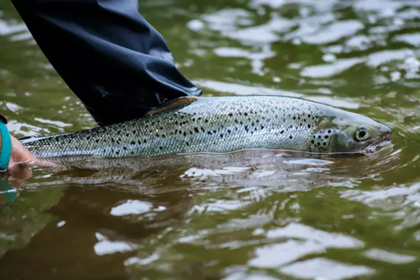
The East Branch of the Penobscot River provides high-quality habitat for the endangered Atlantic Salmon, and preserving the habitat in the Katahdin Woods and Waters National Monument is important for the river's ecosystem. Thousands of hatchery-spawned Atlantic salmon into the East Branch of the Penobscot River in 2023.
The East Branch of the Penobscot River provides high-quality habitat for the endangered Atlantic Salmon, and preserving the habitat in the Katahdin Woods and Waters National Monument is important for the river's ecosystem. Thousands of hatchery-spawned Atlantic salmon into the East Branch of the Penobscot River in 2023.

Main lab of the Research Vessel Marcus G. Langseth (Columbia University - Lamont-Doherty Earth Observatory) while underway conducting multichannel seismic operations.
Spring 2023 Photo Contest Winner: Wayne Baldwin, Honorable Mention category
Main lab of the Research Vessel Marcus G. Langseth (Columbia University - Lamont-Doherty Earth Observatory) while underway conducting multichannel seismic operations.
Spring 2023 Photo Contest Winner: Wayne Baldwin, Honorable Mention category

A USGS hydrologic technician takes a streamflow measurement at Otter Creek in Acadia National Park.
A USGS hydrologic technician takes a streamflow measurement at Otter Creek in Acadia National Park.

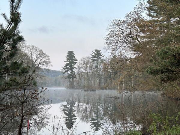
A view of the North and South Bubble Mountains in front of Jordan Pond in Acadia National Park.
A view of the North and South Bubble Mountains in front of Jordan Pond in Acadia National Park.

A hydrologic technician checks data at the Otter Creek streamgage near Bar Harbor, Maine, in Acadia National Park.
A hydrologic technician checks data at the Otter Creek streamgage near Bar Harbor, Maine, in Acadia National Park.

A USGS hydrologic technician takes a streamflow measurement using a current meter in Otter Creek in Acadia National Park.
A USGS hydrologic technician takes a streamflow measurement using a current meter in Otter Creek in Acadia National Park.

Two 4-foot wide baffled chute fishways are tested side-by-side in the Conte Lab's Fish Passage Complex's east flume. The fish ladders are instrumented with passive integrated transponder antennas/reader. River herring, collected from the mouth of the Chicopee River are tested to assess entry and ascent rates.
Two 4-foot wide baffled chute fishways are tested side-by-side in the Conte Lab's Fish Passage Complex's east flume. The fish ladders are instrumented with passive integrated transponder antennas/reader. River herring, collected from the mouth of the Chicopee River are tested to assess entry and ascent rates.

Jeremiah Pomerleau (Maine Office) looks at high-water marks from the Flood at Saco River near Conway, NH station number 01064500. One of the highest flows ever recorded since 1903.
Jeremiah Pomerleau (Maine Office) looks at high-water marks from the Flood at Saco River near Conway, NH station number 01064500. One of the highest flows ever recorded since 1903.

This photograph is of the upstream view from the stream gage on Grave Run near Beckleysville, MD. In the photo Logan Tolley, a hydrologic technician at the Baltimore office, is using a Flowtracker 2 to take a discharge measurement.
Spring 2023 Photo Contest Winner: Rustin Pare, Where We Work category

USGS Fish Biologist Aaron Heisey and EESC colleagues enter the east flume in the Conte Lab's Fish Passage Complex after the conclusion of a study trial to recover adult white suckers.
USGS Fish Biologist Aaron Heisey and EESC colleagues enter the east flume in the Conte Lab's Fish Passage Complex after the conclusion of a study trial to recover adult white suckers.

The USGS is conducting a study to characterize groundwater and surface-water quality to better understand nutrient inputs to the coast. The initial focus of the study is on local-scale hydrologic monitoring adjacent to Academy Cove.
The USGS is conducting a study to characterize groundwater and surface-water quality to better understand nutrient inputs to the coast. The initial focus of the study is on local-scale hydrologic monitoring adjacent to Academy Cove.
Smith Pond is a 15‑acre freshwater pond in Northborough, Massachusetts, forming part of the upper Hop Brook system within the French River watershed.
Smith Pond is a 15‑acre freshwater pond in Northborough, Massachusetts, forming part of the upper Hop Brook system within the French River watershed.

Continuous water quality gaging station located at Farm River at Farm River Marina near East Haven, Connecticut (USGS site ID 411513072512301). The station is placed on the floating dock.
Continuous water quality gaging station located at Farm River at Farm River Marina near East Haven, Connecticut (USGS site ID 411513072512301). The station is placed on the floating dock.

Continuous water quality gaging station located at Farm River at Trolley Museum at East Haven, Connecticut (USGS site ID 411626072514501).
Continuous water quality gaging station located at Farm River at Trolley Museum at East Haven, Connecticut (USGS site ID 411626072514501).