
Fish and Wildlife
Fish and Wildlife
This webpage has links to information about selected fish and wildlife research done by scientists at the USGS Fort Collins Science Center (FORT SC) in Fort Collins, Colorado.
Filter Total Items: 65

Modernized Breeding Bird Survey Portal
The North American Breeding Bird Survey (BBS) Portal is a modern information system that enables volunteer observers and regional coordinators to manage survey routes, enter field data, and coordinate route assignments online. The portal replaces legacy paper-based and outdated digital workflows with a streamlined interface built for the BBS community. Observers can view their assigned routes...
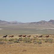
Science for management of America’s iconic wild horses and burros
Wild horses and burros are iconic wildlife of the western USA as well as a complicated management issue on tribal, state, and federal lands. Due to their history as domesticated animals, these wild equids – also called “free-roaming” or “feral” equids – can reproduce quickly, and have few natural predators, allowing their populations to grow rapidly if not managed. When populations are too large...

Data Harmonization for Greater Sage-Grouse Populations
Long-term wildlife monitoring is imperative for understanding population changes that can inform managers. However, working with population data collected by different organizations across multiple jurisdictions and over long time periods can be challenging due to varying data management approaches and organizational priorities. Through this project, we aimed to collaborate with eleven state...

Greater Sage-Grouse Population Monitoring Framework
Greater sage-grouse ( Centrocercus urophasianus) are at the center of state and national land use policies largely because of their unique life-history traits and their role as an ecological indicator for the health of sagebrush ecosystems. Multiple science centers with the U.S. Geological Survey (USGS) in conjunction with Colorado State University (CSU) have developed the Greater Sage-Grouse...

A user-friendly decision support tool for monitoring and managing greater sage-grouse populations
Researchers at the U.S. Geological Survey (USGS) and Colorado State University (CSU) collaborated with the Bureau of Land Management and state wildlife agencies to develop a hierarchical population monitoring framework for managing greater sage-grouse ( Centrocercus urophasianus) populations and the sagebrush ecosystems they depend on for survival and reproduction. This greater sage-grouse...

USGS Sagebrush Science: Supporting Public Safety and Economic Decision Making Across the West
The sagebrush biome is one of the largest ecosystems in North America. Encompassing nearly one-third of the continental U.S., it provides critical resources for millions of Americans and a home for hundreds of plants and animal species in the West. Natural resource management in sagebrush ecosystems can be complex, and science can support management decisions by providing knowledge and tools to...
By
Core Science Systems Mission Area, Ecosystems Mission Area, Biological Threats and Invasive Species Research Program, Climate Adaptation Science Centers, Cooperative Research Units, Land Management Research Program, Species Management Research Program, Earth Resources Observation and Science (EROS) Center, Forest and Rangeland Ecosystem Science Center, Fort Collins Science Center, Northern Rocky Mountain Science Center, Southwest Biological Science Center, Western Ecological Research Center (WERC), Wildland Fire Science

Mapping Chronic Wasting Disease Management: Identify Opportunities for Intervention
This research effort is an interagency partnership between U.S. Geological Survey and U.S. Fish and Wildlife Service to model the social-ecological system that encompasses chronic wasting disease management in the United States. Chronic wasting disease (CWD) is a fatal, neurologically degenerative disease that impacts many cervid species in North America (e.g., elk, moose, mule deer, and white...

The Wildfire Research (WiRē) Team
Wildfires cost billions of dollars to suppress annually, yet they still devastate lives, communities, and ecosystems. While wildfire is a natural phenomenon, learning to live with wildfire is a social issue – so we need a social solution.

Prioritizing restoration and conservation of Wyoming’s sagebrush ecosystems for wildlife and sagebrush connectivity
To support strategic ecosystem management across the imperiled sagebrush steppe in Wyoming, USA, we developed an extension of the Prioritizing Restoration of Sagebrush Ecosystems Tool (PReSET). Our expanded tool leverages emerging spatial data resources to provide a structured but customizable set of scenarios that can guide landscape-scale planning efforts by prioritizing conservation and...

Prioritizing Restoration of Sagebrush Ecosystems Tool (PReSET): A USGS-facilitated Decision-support Tool for Sagebrush Ecosystem Conservation and Restoration Actions
Sagebrush ecosystems represent one of the most imperiled systems in North America and face continued and widespread degradation due to multiple factors including invasive species and increased human development. Effective sagebrush management must consider how to best conserve and restore habitats to stem the decline of species that rely on them, especially given limited conservation resources. To...

Research to support conservation of America’s national mammal, the bison
Once numbering in the tens of millions, plains bison ( Bison bison bison) were nearly driven to extinction with only a few hundred individuals remaining by the late 19th century. Plains bison have since recovered to approximately 20,000 animals managed in conservation herds throughout North America, yet substantial challenges to their recovery remain. The Department of the Interior (DOI) stewards...

Wildlife Economics
Wildlife economics can help us better understand, and sometimes even quantify, the various relationships between humans and wildlife species. On one hand, humans benefit significantly from wildlife, for example through activities like hunting, fishing, and wildlife viewing, or through the conservation of threatened and endangered species. On the other hand, wildlife can also impose substantial...