
Landscape Change
Landscape Change
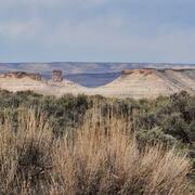
Landscape change is a key driver of environmental change and has important implications related to climate variability and change, biodiversity, natural resources, and ecosystems. This webpage has links to information about landscape change research done by scientists at the USGS Geosciences and Environmental Change Science Center (GEC SC) in Denver, Colorado.
Filter Total Items: 46
AI-driven science synthesis tools for resource managers
The scientific literature is abundant on drought-related topics in the western United States, including areas of the Colorado River Basin and the sagebrush biome. Scientists, resource managers, and decision makers use this science to assess, predict, and respond to the effects of drought on people and the environment. However, it can be difficult to quickly synthesize large amounts of research. To...

USGS Sagebrush Science: Supporting Public Safety and Economic Decision Making Across the West
The sagebrush biome is one of the largest ecosystems in North America. Encompassing nearly one-third of the continental U.S., it provides critical resources for millions of Americans and a home for hundreds of plants and animal species in the West. Natural resource management in sagebrush ecosystems can be complex, and science can support management decisions by providing knowledge and tools to...
By
Core Science Systems Mission Area, Ecosystems Mission Area, Biological Threats and Invasive Species Research Program, Climate Adaptation Science Centers, Cooperative Research Units, Land Management Research Program, Species Management Research Program, Earth Resources Observation and Science (EROS) Center, Forest and Rangeland Ecosystem Science Center, Fort Collins Science Center, Northern Rocky Mountain Science Center, Southwest Biological Science Center, Western Ecological Research Center (WERC), Wildland Fire Science

The Wildfire Research (WiRē) Team
Wildfires cost billions of dollars to suppress annually, yet they still devastate lives, communities, and ecosystems. While wildfire is a natural phenomenon, learning to live with wildfire is a social issue – so we need a social solution.

Prioritizing restoration and conservation of Wyoming’s sagebrush ecosystems for wildlife and sagebrush connectivity
To support strategic ecosystem management across the imperiled sagebrush steppe in Wyoming, USA, we developed an extension of the Prioritizing Restoration of Sagebrush Ecosystems Tool (PReSET). Our expanded tool leverages emerging spatial data resources to provide a structured but customizable set of scenarios that can guide landscape-scale planning efforts by prioritizing conservation and...

Prioritizing Restoration of Sagebrush Ecosystems Tool (PReSET): A USGS-facilitated Decision-support Tool for Sagebrush Ecosystem Conservation and Restoration Actions
Sagebrush ecosystems represent one of the most imperiled systems in North America and face continued and widespread degradation due to multiple factors including invasive species and increased human development. Effective sagebrush management must consider how to best conserve and restore habitats to stem the decline of species that rely on them, especially given limited conservation resources. To...

Prioritizing restoration and conservation of sagebrush ecosystems in northwestern Colorado
We are working with Colorado Parks and Wildlife (CPW) to pilot an expansion of the Prioritizing Restoration of Sagebrush Ecosystems Tool (PReSET; Duchardt et al. 2021) across northwestern Colorado. We recently completed Phase I of this project where we leveraged existing data resources to provide customized scenarios that are now directly guiding landscape-scale conservation delivery by CPW...

Fostering greater use of habitat models for managing rare and invasive plants on public lands
Habitat models can provide critical information on the current and potential distribution of plant species, as well as help target and support conservation efforts. Despite their potential utility in public land management, model use may be constrained by a variety of factors including staff access to and trust in models. In this project, we seek to bring together model users and model developers...

Economic assessment of addressing annual invasive grasses across the sagebrush biome
This interdisciplinary project combines expert judgment on treatment costs with spatially explicit ecological modeling to estimate the financial resources needed to address the threat of invasive annual grass across the entire sagebrush biome. Results of the assessment will provide economic insights that can inform cost-effective resource allocation to efficiently achieve sagebrush conservation...

Creating range-wide predictive maps of Greater Sage-Grouse seasonal habitats
Through a collaborative effort with multiple state and federal agencies, university researchers, and individual stakeholders, we are producing a set of predictive seasonal habitat maps for greater sage-grouse ( Centrocercus urophasianus) spanning the entirety of the species’ U.S. distribution. This is the largest habitat modeling effort of its kind for the species and uses a large, compiled...

INHABIT: A web tool for invasive plant management across the contiguous United States
INHABIT is a desktop-optimized web application and decision support tool with mapped and tabular summaries of habitat suitability models for over two hundred fifty terrestrial invasive plant species of management concern across the contiguous United States. It is the product of a scientist-practitioner partnership and is designed to facilitate enhanced invasive species management actions...

Effects of global change on alpine and subalpine ecosystems
Atmospheric nitrogen deposition, changing environmental patterns, and recreation are rapidly altering high elevation ecosystems. This project will evaluate long-term biogeochemical, hydrological, and ecological trends in Rocky Mountain National Park to understand the causes and rates of change in alpine and subalpine waters, soils, and vegetation. Resource managers of high-elevation, protected...

Predicting Recovery of Sagebrush Ecosystems Across the Sage-grouse Range from Remotely Sensed Vegetation Data
USGS researchers are using remote-sensing and other broadscale datasets to study and predict recovery of sagebrush across the sage-grouse range, assessing influence of disturbance, restoration treatments, soil moisture, and other ecological conditions on trends in sagebrush cover. The results will be used to inform conservation prioritization models, economic analyses, projections of future...