
LCMAP Change Stories: Where the Forests Fall, the Grasses Grow
The forests and rangelands of the Western U.S. face fire dangers on multiple fronts.
The trees themselves provide fuel for wildfires, of course, but there are additional factors at play in this mountainous, forested stretch of land at the Idaho-Montana border.
Insect infestations or diseases that leave felled trees for fuel and precipitation patterns that keep forests dry during the warm summer months can make the area vulnerable to fires ignited by lightning, for example. A 2014 USDA Forest Service Assessment of the Nez Perce-Clearwater National Forests notes increasing temperatures, fuels buildup, insects and disease, and reduced precipitation among the risk factors. It also points to an increase in burned acres between 1985-2010 over mid-century levels.

This animation shows an area that includes parts of several National Forests, Nez Perce among them. The Monitoring Trends in Burn Severity (MTBS) program mapped over 200 individual fire events within its extent between 1984 and 2016.
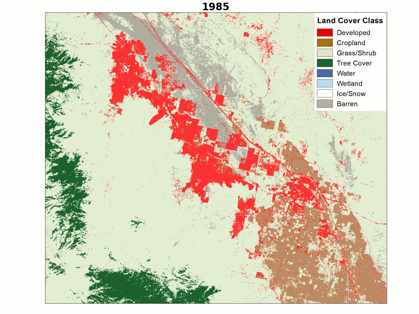
The impact of those disturbances is clear when viewed through the lens of two USGS Land Change Monitoring, Assessment, and Projection (LCMAP) Collection 1 Science products—Primary Land Cover and Change Magnitude.
This visualization lays the borders of a handful of the larger fires mapped by MTBS atop the two LCMAP products. Change Magnitude is on the right. Flashes of green, yellow and blue color in a given frame reflect significant spectral change in the USGS Landsat data record for that year. Watch carefully, and you’ll see how flare-ups of spectral change in the LCMAP product coincide with the MTBS-identified fire events.
The left side shows Primary Land Cover from 1985-2017. After fires move through the area the tree canopy is thinned and pixels move from green to tan, denoting the emergence of herbaceous vegetation and a shift in land cover class from Tree Cover to Grass/Shrub. Canopy slowly regrows in some areas, but Grass/Shrub remains dominant in several areas in 2017. Comparing 1985 to 2017 shows a regional reduction in Tree Cover.
Comparing data from LCMAP Science Products can help us understand land cover change across the Nation.

Related
Explore more LCMAP Change Stories by following the links below.

LCMAP Change Stories: Crops Give Way to Concrete LCMAP Change Stories: Crops Give Way to Concrete
LCMAP Change Stories LCMAP Change Stories

LCMAP Change Stories: Where the Ocean Eats the Land LCMAP Change Stories: Where the Ocean Eats the Land
LCMAP Change Stories: Building a Boomtown, Block by Block

LCMAP Change Stories: Gone in 60 Seconds
LCMAP Change Stories: It's a Sprawl World After All

LCMAP Change Stories: Alabama Tornadoes
Related
Explore more LCMAP Change Stories by following the links below.
LCMAP Change Stories: Crops Give Way to Concrete LCMAP Change Stories: Crops Give Way to Concrete
LCMAP Change Stories LCMAP Change Stories
LCMAP Change Stories: Where the Ocean Eats the Land LCMAP Change Stories: Where the Ocean Eats the Land
LCMAP Change Stories: Building a Boomtown, Block by Block
LCMAP Change Stories: Gone in 60 Seconds
LCMAP Change Stories: It's a Sprawl World After All