
Education
Learn more about LCMAP
Filter Total Items: 14

Concept to Reality USGS Land Change Monitoring Assessment and Projection Pushes Boundaries Concept to Reality USGS Land Change Monitoring Assessment and Projection Pushes Boundaries
More than a decade ago, Tom Loveland sat down to sketch out a few thoughts on land change and the Landsat archive. The archive was and remains rich with history, adding new observations of the entire planet every eight days. But at that point, Landsat-based land change research was about comparing points in time – this year versus five years ago, to 10 years ago, and so on.

Tracking Change Across Time and Space Tracking Change Across Time and Space
The U.S. Geological Survey took a bold step toward documenting change across the landscape with the launch of the first Landsat satellite in 1972. Since then, the orbiters have collected nearly five decades of imagery.

Eyes on Earth Episode 71 – Blue Oak Forests of California Eyes on Earth Episode 71 – Blue Oak Forests of California
Eyes on Earth is a podcast on remote sensing, Earth observation, land change and science, brought to you by the USGS Earth Resources Observation and Science (EROS) Center. In this episode, we learn how Landsat-based data products have been used to study forest change in California.

Eyes on Earth Episode 69 - Thirty Years of Land Change in the U.S. Eyes on Earth Episode 69 - Thirty Years of Land Change in the U.S.
Eyes on Earth is a podcast on remote sensing, Earth observation, land change and science, brought to you by the USGS Earth Resources Observation and Science (EROS) Center. In this episode, we learn how the landscapes of the U.S. have changed since 1985.

LCMAP Class Legend and Description LCMAP Class Legend and Description
LCMAP land cover products provide information about land cover classification, including land cover classification information for a given area before and after change is detected by Continuous Change Detection and Classification. The five land cover products are built on broad Anderson Land Cover Classification System Level 1 based classes.

LCMAP Did You Know? LCMAP Did You Know?
Below you'll find answers to common questions about USGS Land Change Monitoring, Assessment, and Projection (LCMAP).

Eyes on Earth Episode 40 – Landsat Collection 2 Eyes on Earth Episode 40 – Landsat Collection 2
Eyes on Earth is a podcast on remote sensing, Earth observation, land change and science, brought to you by the USGS Earth Resources Observation and Science (EROS) Center. In this episode, we learn how a Collections strategy boosts the value of the Landsat archive.

LCMAP Change Stories: Outfitting the Ozarks LCMAP Change Stories: Outfitting the Ozarks
The meandering shoreline is the claim to fame for the Midwestern tourist oasis that is Lake of the Ozarks in Central Missouri. The Missouri Division of Tourism’s website leads its page on the state’s most popular visitor destination by noting that the lake’s 1,100 miles of freshwater coast are more than even California has to offer.

LCMAP Change Stories: Where the Forests Fall, the Grasses Grow LCMAP Change Stories: Where the Forests Fall, the Grasses Grow
The forests and rangelands of the Western U.S. face fire dangers on multiple fronts. The trees themselves provide fuel for wildfires, of course, but there are additional factors at play in this mountainous, forested stretch of land at the Idaho-Montana border.

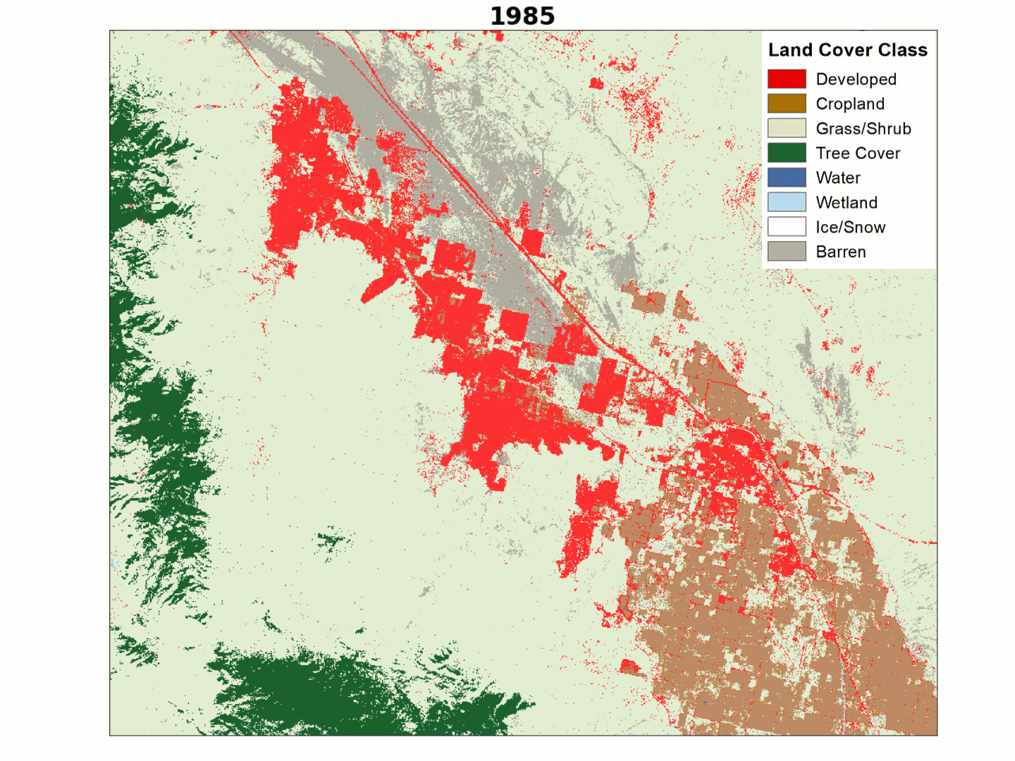
LCMAP Change Stories: Crops Give Way to Concrete LCMAP Change Stories: Crops Give Way to Concrete
Less than 15 miles separate the city of Plainfield from the nearby metropolis of Indianapolis, the capital of Indiana and the state’s largest urban center.
Eyes on Earth Episode 29 – Tracking Landscape Change with LCMAP Eyes on Earth Episode 29 – Tracking Landscape Change with LCMAP
Eyes on Earth is a podcast on remote sensing, Earth observation, land change and science, brought to you by the USGS Earth Resources Observation and Science (EROS) Center. In this episode, we learn about an exciting new initiative to track landscape change in the U.S.
LCMAP Change Stories LCMAP Change Stories
Click the "Science" links below to see how we track change over time.