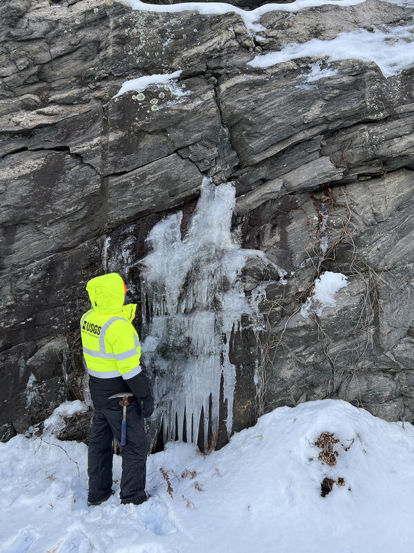
I am a Project Leader and a Supervisory Research Geologist with the Florence Bascom Geoscience Center. I manage bedrock geologic mapping activities for the USGS in the northeastern United States. I managed two international mapping projects in Morocco, the completion of the new bedrock geologic map of Vermont, and I conducted mapping Madagascar.
I have expertise in geologic mapping, structural geology, geochronology, tectonics, digital cartography, and GIS. I specialize in the mapping, structure, and tectonics of complexly deformed rocks, the integration of geologic data with hydrogeologic and mineral resource assessment studies, and the use of GIS as a mapping and analysis tool. I have trained students and geologists in geologic mapping, GIS, GPS, digital mapping, and U-Pb geochronology by SHRIMP. The Publications listed on the tab below is automatically generated and incomplete. Please contact me if you would like a copy of my current CV.
Professional Experience
1992-Present, Research Geologist, U.S. Geological Survey, Reston, Virginia and Montpelier, Vermont
1990-1992, Consulting Geologist, Heindel and Noyes, Inc., Burlington, Vermont
1988-1990, Contractor, Vermont Agency of Natural Resources, Waterbury, Vermont
1986-1988, Teaching Assistant, University of Vermont, Department of Geology, Burlington, Vermont
1986, NAGT Intern Geologist, U.S. Geological Survey, Menlo Park, California
Education and Certifications
M.S. in Geology / University of Vermont, Burlington, Vermont USA, 1989
B.S. in Geology / University of Massachusetts, Amherst, Massachusetts, 1986
Affiliations and Memberships*
2013-Present, Fellow, Geological Society of America
1988-2013, Member, Geological Society of America
2013-2014, Elected Vice-Chair, Geological Society of America, Northeastern Section Management Board
2014-2015, Chair, Geological Society of America, Northeastern Section Management Board
2015-2016, Past-Chair, Geological Society of America, Northeastern Section Management Board
2012-Present, Member, Connecticut Geological Society
1998-Present, Member, New Hampshire Geological Society
1992-Present, Member, Vermont Geological Society
Honors and Awards
Dean’s List five semesters (1982-1986)
Amoco Geophysics Award (1985)
NAGT – USGS Student Internship (1985)
L.R. Wilson Award, UMASS Amherst (1986)
Charles G. Doll Award, Vermont Geological Society (1988)
Twenty-one USGS performance awards (1997-2021)
Elected GSA Fellow (2013)
Science and Products
Northeast Bedrock Mapping Project
Whole rock geochemistry data from the Ordovician Bronson Hill arc and Silurian and Devonian Connecticut Valley - Gaspé trough, Vermont and New Hampshire
Database of historical anthracite coal-mining infrastructure at the northern end of the Lackawanna syncline, Wayne, Susquehanna, and Lackawanna counties, Pennsylvania
Whole rock geochemistry and uranium-lead isotopic data from Mesoproterozoic rocks in the Eagle Lake quadrangle, Essex County, New York
Electron microprobe and 40Ar/39Ar isotopic data from west-central New Hampshire
Data release for depth to bedrock from Connecticut Water Resources Bulletins
Photoluminescence Imaging of Whole Zircon Grains on a Petrographic Microscope - An Underused Aide for Geochronologic Studies
Electron microprobe analyses of feldspars and petrographic, geochemical, and geochronologic data from the Hawkeye Granite Gneiss and Lyon Mountain Granite Gneiss in the Adirondacks of New York (ver. 2.0, May 2023)
Petrophysical data collected on outcrops and rock samples from the eastern Adirondack Highlands, New York
GIS and Data Tables for Focus Areas for Potential Domestic Nonfuel Sources of Rare Earth Elements
Geochemistry of ore, host rock, and mine waste pile samples of iron oxide-apatite (IOA) deposits of the eastern Adirondack Highlands, New York, in relation to potential rare earth elements resources, 2016-2018
Percent-slope map showing historical anthracite coal-mining infrastructure at the northern end of the Lackawanna syncline, Wayne, Susquehanna, and Lackawanna Counties, Pennsylvania
Bedrock geologic map of the Crown Point quadrangle, Essex County, New York, and Addison County, Vermont
Bedrock geologic map of the Springfield 7.5- x 15-minute quadrangle, Windsor County, Vermont, and Sullivan County, New Hampshire
Bedrock geologic map of the Mount Ascutney 7.5- x 15-minute quadrangle, Windsor County, Vermont, and Sullivan County, New Hampshire
Bedrock geologic map of the Hartland and North Hartland quadrangles, Windsor County, Vermont, and Sullivan and Grafton Counties, New Hampshire
Bedrock geologic map of the Worcester South quadrangle, Worcester County, Massachusetts
Bedrock geologic map of the Uxbridge quadrangle, Worcester County, Massachusetts, and Providence County, Rhode Island
Bedrock geologic map of the Nashua South quadrangle, Hillsborough County, New Hampshire, and Middlesex County, Massachusetts
Implementation plan of the National Cooperative Geologic Mapping Program strategy—Northeast region of the United States: New York and New England
An apparent dip calculator for spreadsheets
Age and tectonic setting of the Quinebaug-Marlboro belt and implications for the history of Ganderian crustal fragments in southeastern New England, USA
New interpretations of the ages and origins of the Hawkeye Granite Gneiss and Lyon Mountain Granite Gneiss, Adirondack Mountains, NY: Implications for the nature and timing of Mesoproterozoic plutonism, metamorphism, and deformation
Renewing the National Cooperative Geologic Mapping Program as the Nation’s authoritative source for modern geologic knowledge
Unmixing multiple metamorphic muscovite age populations with powder X-ray diffraction and 40Ar/39Ar analysis
Integrated geophysical imaging of rare-earth-element-bearing iron oxide-apatite deposits in the eastern Adirondack Highlands, New York
Photoluminescence imaging of whole zircon grains on a petrographic microscope—An underused aide for geochronologic studies
The refractory nature of zircon to temperature and pressure allows even a single zircon grain to preserve a rich history of magmatic, metamorphic, and hydrothermal processes. Isotopic dating of micro-domains exposed in cross-sections of zircon grains allows us to interrogate this history. Unfortunately, our ability to select the zircon grains in a heavy mineral concentrate that records the most ge
A transect through Vermont's most famous volcano - Mount Ascutney
Geochronology of the Oliverian Plutonic Suite and the Ammonoosuc Volcanics in the Bronson Hill arc: Western New Hampshire, USA
U-Pb zircon geochronology by sensitive high-resolution ion microprobe–reverse geometry (SHRIMP-RG) on 11 plutonic rocks and two volcanic rocks from the Bronson Hill arc in western New Hampshire yielded Early to Late Ordovician ages ranging from 475 to 445 Ma. Ages from Oliverian Plutonic Suite rocks that intrude a largely mafic lower section of the Ammonoosuc Volcanics ranged from 474.8 ± 5.2 to 4
Geochemistry and geophysics of iron oxide-apatite deposits and associated waste piles with implications for potential rare earth element resources from ore and historic mine waste in the eastern Adirondack Highlands, New York, USA
Syn-collisional exhumation of hot middle crust in the Adirondack Mountains (New York, USA): Implications for extensional orogenesis in the southern Grenville province
Science and Products
- Science
Northeast Bedrock Mapping Project
The Northeast Bedrock Mapping Project consists of scientists conducting geologic mapping and scientific research of complexly deformed crystalline igneous and metamorphic rocks in the Northeastern United States. Current mapping activities are focused in New Hampshire, Vermont, Connecticut, and New York. The Project produces high-quality, multi-purpose digital geologic maps and accompanying... - Data
Whole rock geochemistry data from the Ordovician Bronson Hill arc and Silurian and Devonian Connecticut Valley - Gaspé trough, Vermont and New Hampshire
This data release includes whole rock (WR) geochemical data for 94 samples. Whole rock geochemistry data were analyzed at Actlabs in Ancaster, Ontario, Canada. Rock samples were collected by Peter Valley, Greg Walsh, Arthur Merschat, and Ryan McAleer. The whole rock geochemistry data characterize the composition of mapped meta-igneous rocks in eastern Vermont and western New Hampshire, USA. The daDatabase of historical anthracite coal-mining infrastructure at the northern end of the Lackawanna syncline, Wayne, Susquehanna, and Lackawanna counties, Pennsylvania
Abandoned railroads and infrastructure from the anthracite coal mining industry are significant features in abandoned mine lands and are an important part of history; however, these features are often lost and masked by the passage of time and the regrowth of forests. The application of modern light detection and ranging (lidar) topographic analysis, combined with ground-truthing "boots on the groWhole rock geochemistry and uranium-lead isotopic data from Mesoproterozoic rocks in the Eagle Lake quadrangle, Essex County, New York
This data release includes whole rock (WR) geochemical data, and uranium-lead isotopic data collected using a sensitive high resolution ion microprobe-reverse geometry (SHRIMP-RG) instrument; the SHRIMP-RG is a type of secondary ion mass spectrometer (SIMS). Whole rock geochemistry data were analyzed at Bureau Veritas Commodities Canada Ltd. Laboratories in Vancouver, British Columbia, Canada. SHRElectron microprobe and 40Ar/39Ar isotopic data from west-central New Hampshire
This dataset accompanies planned publication 'Unmixing multiple metamorphic muscovite age populations with powder X-ray diffraction and 40Ar/39Ar analysis'. The 40Ar/39Ar and electron microprobe data are from samples adjacent to a lower greenschist facies shear zone in western New Hampshire. The geochronology coupled with the electron microprobe data provide a petrochronologic framework for the roData release for depth to bedrock from Connecticut Water Resources Bulletins
This data release consists of information from published tables in Connecticut Water Resources Bulletins (WRBs) transcribed into tabular digital format. Information about wells and test holes in the WRBs used in this data release consists of geographic location, depth to consolidated rock (bedrock depth), and depth of the well or test hole. The WRBs, published between 1966 and 1980 by the U.S. GeoPhotoluminescence Imaging of Whole Zircon Grains on a Petrographic Microscope - An Underused Aide for Geochronologic Studies
The refractory nature of zircon to temperature and pressure allows even a single zircon grain to preserve a rich history of magmatic, metamorphic, and hydrothermal processes. Isotopic dating of micro-domains exposed in cross-sections of zircon grains allows us to interrogate this history. Unfortunately, our ability to select the zircon grains in a heavy mineral concentrate that records the most geElectron microprobe analyses of feldspars and petrographic, geochemical, and geochronologic data from the Hawkeye Granite Gneiss and Lyon Mountain Granite Gneiss in the Adirondacks of New York (ver. 2.0, May 2023)
Iron oxide-apatite (IOA) deposits of the Adirondack Mountains of New York locally contain elevated rare earth element (REE) concentrations (e.g. Taylor and others, 2019). Critical to evaluating resource potential is understanding the genesis of the IOA deposits that host the REE-rich minerals. As part of this effort, the U.S. Geological Survey (USGS) is conducting bedrock geologic mapping, geochPetrophysical data collected on outcrops and rock samples from the eastern Adirondack Highlands, New York
Petrophysical data were collected in the eastern Adirondack Highlands during several field campaigns in 2016-2017. This data release provides magnetic susceptibility, gamma spectrometry, and density measurements on rock outcrops, hand samples, and during walking surveys. Rock types for the outcrops and samples were identified using standard field methods. Locations of the outcrops or samples wereGIS and Data Tables for Focus Areas for Potential Domestic Nonfuel Sources of Rare Earth Elements
In response to Executive Order 13817 of December 20, 2017, the U.S. Geological Survey (USGS) coordinated with the Bureau of Land Management (BLM) to identify 35 nonfuel minerals or mineral materials considered critical to the economic and national security of the United States (U.S.). Acquiring information on possible domestic sources of these critical minerals is the basis of the USGS Earth MappiGeochemistry of ore, host rock, and mine waste pile samples of iron oxide-apatite (IOA) deposits of the eastern Adirondack Highlands, New York, in relation to potential rare earth elements resources, 2016-2018
Thirty-four ore, twenty-nine mine waste, seven host rock, two pegmatite, and one slag sample were collected from iron oxide-apatite (IOA) mines in the eastern Adirondack Highlands near Mineville and Ticonderoga, New York, from March 2016 to August 2018. The waste pile samples included twenty-five samples collected from rubble-sized mine waste piles and four samples from processed tailings piles. - Maps
Filter Total Items: 19
Percent-slope map showing historical anthracite coal-mining infrastructure at the northern end of the Lackawanna syncline, Wayne, Susquehanna, and Lackawanna Counties, Pennsylvania
Introduction Abandoned railroads and infrastructure from the anthracite coal-mining industry are significant features in abandoned mine lands and are an important part of history; however, these features are often lost and masked by the passage of time and the regrowth of forests. The application of modern light detection and ranging (lidar) topographic analysis, combined with field verification,Bedrock geologic map of the Crown Point quadrangle, Essex County, New York, and Addison County, Vermont
The bedrock geology of the 7.5-minute Crown Point quadrangle consists of deformed and metamorphosed Mesoproterozoic gneisses of the Adirondack Highlands unconformably overlain by weakly deformed lower Paleozoic sedimentary rocks of the Champlain Valley. The Mesoproterozoic rocks occur on the eastern edge of the Adirondack Highlands and represent an extension of the Grenville Province of Laurentia.Bedrock geologic map of the Springfield 7.5- x 15-minute quadrangle, Windsor County, Vermont, and Sullivan County, New Hampshire
The bedrock geology of the 7.5- by 15-minute Springfield quadrangle consists of highly deformed and metamorphosed Mesoproterozoic through Devonian metasedimentary and meta-igneous rocks. In the west, Mesoproterozoic gneisses of the Mount Holly Complex are the oldest rocks and form the eastern side of the Chester dome. The Moretown slice structurally overlies the Chester dome along the Keyes MountaBedrock geologic map of the Mount Ascutney 7.5- x 15-minute quadrangle, Windsor County, Vermont, and Sullivan County, New Hampshire
The bedrock geology of the Mount Ascutney 7.5- x 15-minute quadrangle consists of highly deformed and metamorphosed Mesoproterozoic through Devonian metasedimentary and meta-igneous rocks intruded by rocks of the Mesozoic White Mountain Igneous Suite. In the west, Mesoproterozoic gneisses of the Mount Holly Complex are the oldest rocks and form the northeastern flank of the Chester dome. The allocBedrock geologic map of the Hartland and North Hartland quadrangles, Windsor County, Vermont, and Sullivan and Grafton Counties, New Hampshire
The bedrock geology of the 7.5-minute Hartland and North Hartland quadrangles, Vermont-New Hampshire, consists of highly deformed and metamorphosed lower Paleozoic metasedimentary, metavolcanic, and metaplutonic rocks of the Bronson Hill anticlinorium (BHA) and the Connecticut Valley trough (CVT). Rocks of the Orfordville anticlinorium on this map occupy the western part of the broader BHA. In theBedrock geologic map of the Hartland and North Hartland quadrangles, Windsor County, Vermont, and Sullivan and Grafton Counties, New Hampshire
The bedrock geology of the 7.5-minute Hartland and North Hartland quadrangles, Vermont-New Hampshire, consists of highly deformed and metamorphosed lower Paleozoic metasedimentary, metavolcanic, and metaplutonic rocks of the Bronson Hill anticlinorium (BHA) and the Connecticut Valley trough (CVT). Rocks of the Orfordville anticlinorium on this map occupy the western part of the broader BHA. In theBedrock geologic map of the Worcester South quadrangle, Worcester County, Massachusetts
The bedrock geology of the 7.5-minute Worcester South quadrangle, Massachusetts, consists of deformed Neoproterozoic to Paleozoic crystalline metamorphic and intrusive igneous rocks in three fault-bounded terranes (zones), including the Avalon, Nashoba, and Merrimack zones (Zen and others, 1983). This quadrangle spans the easternmost occurrence of Ganderian margin arc-related rocks (Nashoba zone)Bedrock geologic map of the Worcester South quadrangle, Worcester County, Massachusetts
The bedrock geology of the 7.5-minute Worcester South quadrangle, Massachusetts, consists of deformed Neoproterozoic to Paleozoic crystalline metamorphic and intrusive igneous rocks in three fault-bounded terranes (zones), including the Avalon, Nashoba, and Merrimack zones (Zen and others, 1983). This quadrangle spans the easternmost occurrence of Ganderian margin arc-related rocks (Nashoba zone)Bedrock geologic map of the Uxbridge quadrangle, Worcester County, Massachusetts, and Providence County, Rhode Island
The bedrock geology of the 7.5-minute Uxbridge quadrangle consists of Neoproterozoic metamorphic and igneous rocks of the Avalon zone. In this area, rocks of the Avalon zone lie within the core of the Milford antiform, south and east of the terrane-bounding Bloody Bluff fault zone. Permian pegmatite dikes and quartz veins occur throughout the quadrangle. The oldest metasedimentary rocks include thBedrock geologic map of the Uxbridge quadrangle, Worcester County, Massachusetts, and Providence County, Rhode Island
The bedrock geology of the 7.5-minute Uxbridge quadrangle consists of Neoproterozoic metamorphic and igneous rocks of the Avalon zone. In this area, rocks of the Avalon zone lie within the core of the Milford antiform, south and east of the terrane-bounding Bloody Bluff fault zone. Permian pegmatite dikes and quartz veins occur throughout the quadrangle. The oldest metasedimentary rocks include thBedrock geologic map of the Nashua South quadrangle, Hillsborough County, New Hampshire, and Middlesex County, Massachusetts
The bedrock geology of the 7.5-minute Nashua South quadrangle consists primarily of deformed Silurian metasedimentary rocks of the Berwick Formation. The metasedimentary rocks are intruded by a Late Silurian to Early Devonian diorite-gabbro suite, Devonian rocks of the Ayer Granodiorite, Devonian granitic rocks of the New Hampshire Plutonic Suite including pegmatite and the Chelmsford Granite, andBedrock geologic map of the Nashua South quadrangle, Hillsborough County, New Hampshire, and Middlesex County, Massachusetts
The bedrock geology of the 7.5-minute Nashua South quadrangle consists primarily of deformed Silurian metasedimentary rocks of the Berwick Formation. The metasedimentary rocks are intruded by a Late Silurian to Early Devonian diorite-gabbro suite, Devonian rocks of the Ayer Granodiorite, Devonian granitic rocks of the New Hampshire Plutonic Suite including pegmatite and the Chelmsford Granite, and - Multimedia
- Publications
Filter Total Items: 77
Implementation plan of the National Cooperative Geologic Mapping Program strategy—Northeast region of the United States: New York and New England
Complexly deformed igneous, metamorphic, and sedimentary rocks form the bedrock of the Northeast region of the United States. Variably thick unconsolidated sediments deposited by glacial, fluvial, and eolian systems locally cover the bedrock. New geologic mapping focuses on areas lacking modern, detailed studies or syntheses, and contributes to existing framework research. This report addresses plAuthorsGregory J. Walsh, Margaret A. Thomas, Robert G. Marvinney, Stephen B. Mabee, Frederick H. Chormann, Andrew Kozlowski, Marjorie H. Gale, Jon Kim, Brian SavageAn apparent dip calculator for spreadsheets
This report and spreadsheet calculator contain Microsoft Excel-based equations that are useful in structural geology to calculate plunge or apparent dip when measuring lineations on a plane. The spreadsheet allows users to measure the trend or the plunge of a lineation and calculate the corresponding unknown value of trend or plunge. The spreadsheet provides the user with two options:Option 1: CalAuthorsGregory J. WalshAge and tectonic setting of the Quinebaug-Marlboro belt and implications for the history of Ganderian crustal fragments in southeastern New England, USA
Crustal fragments underlain by high-grade rocks represent a challenge to plate reconstructions, and integrated mapping, geochronology, and geochemistry enable the unravelling of the temporal and spatial history of exotic crustal blocks. The Quinebaug-Marlboro belt (QMB) is an enigmatic fragment on the trailing edge of the peri-Gondwanan Ganderian margin of southeastern New England. SHRIMP U-Pb geoAuthorsGregory J. Walsh, John N. Aleinikoff, Robert A. Ayuso, Robert P. WintschNew interpretations of the ages and origins of the Hawkeye Granite Gneiss and Lyon Mountain Granite Gneiss, Adirondack Mountains, NY: Implications for the nature and timing of Mesoproterozoic plutonism, metamorphism, and deformation
The Hawkeye Granite Gneiss and Lyon Mountain Granite Gneiss are widespread Mesoproterozoic plutonic rocks that occur in the amphibolite- to granulite-facies Adirondack Highlands of northern New York, USA. The strongly deformed Hawkeye Granite Gneiss, previously dated by zircon multi-grain thermal ionization mass spectrometry (TIMS) U-Pb analyses at about 1100 Ma, was intruded by the weakly deformeAuthorsJohn N. Aleinikoff, Gregory J. Walsh, Ryan J. McAleerRenewing the National Cooperative Geologic Mapping Program as the Nation’s authoritative source for modern geologic knowledge
This document presents the renewed vision, mission, and goals for the National Cooperative Geologic Mapping Program (NCGMP). The NCGMP, as authorized by the National Cooperative Geologic Mapping Act of 1992 (Public Law 102-285, 106 Stat. 166 and its reauthorizations), is tasked with expediting the production of a geologic database for the Nation based on modern geologic maps and their supporting dAuthorsJohn Brock, Karen Berry, James Faulds, Richard Berg, Kyle House, Michael Marketti, Darcy McPhee, Kevin M. Schmidt, James Schmitt, David R. Soller, David Spears, Ren A. Thompson, Harvey Thorleifson, Gregory J. WalshUnmixing multiple metamorphic muscovite age populations with powder X-ray diffraction and 40Ar/39Ar analysis
A combination of modal estimates from powder X-ray diffraction (XRD) experiments and argon isotopic data shows that muscovite 40Ar/39Ar total gas age correlates with muscovite composition near the retrograde Bald Mountain shear zone (BMSZ) in Claremont, New Hampshire, and that the shear zone was active at ∼245 Ma. Petrologic study demonstrates that chemical disequilibrium is preserved in muscoviteAuthorsRyan J. McAleer, David Bish, Michael J. Kunk, Peter M. Valley, Gregory J. Walsh, Robert WintschIntegrated geophysical imaging of rare-earth-element-bearing iron oxide-apatite deposits in the eastern Adirondack Highlands, New York
The eastern Adirondack Highlands of northern New York host dozens of iron oxide-apatite (IOA) deposits containing magnetite and rare earth element (REE)-bearing apatite. We use new aeromagnetic, aeroradiometric, ground gravity, and sample petrophysical and geochemical data to image and understand these deposits and their geologic framework. Aeromagnetic total field data reflect highly magnetic leuAuthorsAnjana K. Shah, Ryan D. Taylor, Gregory J. Walsh, Jeffrey PhillipsPhotoluminescence imaging of whole zircon grains on a petrographic microscope—An underused aide for geochronologic studies
The refractory nature of zircon to temperature and pressure allows even a single zircon grain to preserve a rich history of magmatic, metamorphic, and hydrothermal processes. Isotopic dating of micro-domains exposed in cross-sections of zircon grains allows us to interrogate this history. Unfortunately, our ability to select the zircon grains in a heavy mineral concentrate that records the most ge
AuthorsRyan J. McAleer, Aaron M. Jubb, Paul C. Hackley, Gregory J. Walsh, Arthur J. Merschat, Sean P. Regan, William C. Burton, Jorge A. VazquezA transect through Vermont's most famous volcano - Mount Ascutney
The Cretaceous Ascutney Mountain igneous complex affords a classic exposure of the White Mountain Igneous Suite. Often called Vermont’s most famous volcano, Mount Ascutney (elev. 3,144 feet, 958 m) stands as a prominent monadnock in the Connecticut River Valley. The mountain often serves as an inspirational landmark, as it does when viewed from locations throughout the valley including the Saint-AuthorsGregory J. Walsh, Brooks P. Proctor, Karri R. Sicard, Peter M. ValleyGeochronology of the Oliverian Plutonic Suite and the Ammonoosuc Volcanics in the Bronson Hill arc: Western New Hampshire, USA
U-Pb zircon geochronology by sensitive high-resolution ion microprobe–reverse geometry (SHRIMP-RG) on 11 plutonic rocks and two volcanic rocks from the Bronson Hill arc in western New Hampshire yielded Early to Late Ordovician ages ranging from 475 to 445 Ma. Ages from Oliverian Plutonic Suite rocks that intrude a largely mafic lower section of the Ammonoosuc Volcanics ranged from 474.8 ± 5.2 to 4
AuthorsPeter M. Valley, Gregory J. Walsh, Arthur J. Merschat, Ryan J. McAleerGeochemistry and geophysics of iron oxide-apatite deposits and associated waste piles with implications for potential rare earth element resources from ore and historic mine waste in the eastern Adirondack Highlands, New York, USA
The iron oxide-apatite (IOA) deposits of the eastern Adirondack Highlands, New York, are historical high-grade magnetite mines that contain variable concentrations of rare earth element (REE)-bearing apatite crystals. The majority of the deposits are hosted within sodically altered Lyon Mountain granite gneiss, although some deposits occur within paragneiss, gabbro, anorthosite, or potassically alAuthorsRyan Taylor, Anjana K. Shah, Gregory J. Walsh, Cliff D. TaylorSyn-collisional exhumation of hot middle crust in the Adirondack Mountains (New York, USA): Implications for extensional orogenesis in the southern Grenville province
Extensional deformation in the lower to middle continental crust is increasingly recognized and shown to have significant impact on crustal architecture, magma emplacement, fluid flow, and ore deposits. Application of the concept of extensional strain to ancient orogenic systems, like the Grenville province of eastern North America, has helped decipher the structural evolution of these regions. ThAuthorsSean Regan, Gregory J. Walsh, Michael L. Williams, Jeffrey R. Chiarenzelli, Megan E. Toft, Ryan J. McAleer
*Disclaimer: Listing outside positions with professional scientific organizations on this Staff Profile are for informational purposes only and do not constitute an endorsement of those professional scientific organizations or their activities by the USGS, Department of the Interior, or U.S. Government