
Jack Eggleston
Jack Eggleston is the Chief of the Hydrologic Remote Sensing Branch for the USGS Water Resources Mission Area.
Jack is a hydrologist and remote sensing scientist who leads the Hydrologic Remote Sensing Branch (HRSB) of the U.S. Geological Survey (USGS). HRSB improves USGS water resource monitoring by developing and testing new remote sensing and hydrogeophysical technologies. The hydrologists, geographers, software developers, and data scientists of HRSB figure out how to collect and use hydrologic data from satellites, planes, drones, cameras, radar, and geophysical technologies. These new tools reduce water monitoring costs, expand spatial coverage of USGS monitoring, improve safety, and reveal new insights into the water cycle and water quality.
Jack leads HRSB in supporting public need for accurate and comprehensive water data across the nation. By building collaborations between USGS-HRSB and partners in industry, academia, and other government agencies, he helps USGS stay current with the latest remote sensing science and technologies. High profile accomplishments by HRSB under Jack’s leadership include:
- Water Information from Space (WISP) – US water data from satellites
- Hot Stream Cold Stream – Video on groundwater affecting stream temperature
- Sattrax-AK - Alaska river width measurement by satellite (requires Google login)
- Identifying Algae from Space – Hyperspectral satellite data analysis, EOS article
- Remote Sensing of Streamflow in Alaska – Fact sheet on satellite streamgaging
Science and Products
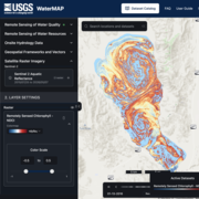
WaterMAP: Water Monitoring Above the Planet

Satellite-based Remote Sensing of River Discharge
Science and Products
WaterMAP: Water Monitoring Above the Planet