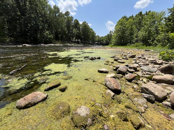
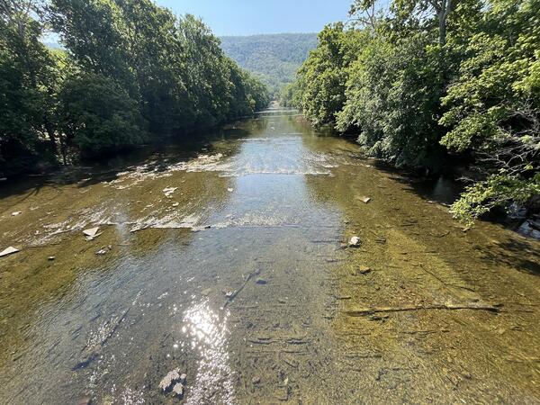
U.S. flag

An official website of the United States government

Images

Images intro.
Filter Total Items: 303
Close-up of algal mats growing over a rocky streambank.
Algae Mat from a Harmful Algal Bloom

Algae growing over the rocky streambank of the south fork of the Shenandoah River near Lynnwood, Virginia.

This photo was taken as a part of the Shenandoah River HABs Project.

Algae growing over the rocky streambank of the south fork of the Shenandoah River near Lynnwood, Virginia.

This photo was taken as a part of the Shenandoah River HABs Project.

A scientist works on a rail system along the Shenandoah River at sunset.
Monitoring equipment along the North Fork Shenandoah River

A USGS scientist servicing a rail system along the banks of the North Fork Shenandoah River near Strausburg. Rail systems are used to deploy continuous water chemistry monitoring equipment in large rivers such as the Shenandoah.

A USGS scientist servicing a rail system along the banks of the North Fork Shenandoah River near Strausburg. Rail systems are used to deploy continuous water chemistry monitoring equipment in large rivers such as the Shenandoah.

A floating algal mat forming along the edge of the riverbank of the Shenandoah River.
Algal Mat from a Harmful Algal Bloom

Algae growing in a backwater section along the streambank of the south fork of the Shenandoah River near Lynnwood, Virginia.

This photo was taken as a part of the Shenandoah River HABs Project.

Algae growing in a backwater section along the streambank of the south fork of the Shenandoah River near Lynnwood, Virginia.

This photo was taken as a part of the Shenandoah River HABs Project.

View of the Shenandoah River from a bridge. A pocket of dense algae can be seen along the shoreline.
South Fork of the Shenandoah River near Lynnwood

Algae growing along a backwater section along the streambank of the south fork of the Shenandoah River near Lynnwood, Virginia.

This photo was taken as a part of the Shenandoah River HABs Project.

Algae growing along a backwater section along the streambank of the south fork of the Shenandoah River near Lynnwood, Virginia.

This photo was taken as a part of the Shenandoah River HABs Project.

North Fork Shenandoah River during a Harmful Algal Bloom Event

North Fork Shenandoah River during a Harmful Algal Bloom (HAB) event. 

This photo was taken near Town Park in Strausburg, and is a part of the Shenandoah River HABs Project.

The Shenandoah River during a harmful algal bloom event. The water is brownish and dying algae coats the riverbed.
Deer Rapids after a HABs Event

Deer Rapids, on the North Fork of the Shenandoah River in Virginia, after a harmful algal bloom (HAB) event. Note how the dark greenish-brown, dead or dying filamentous algae still coats the riverbed.

Data for this monitoring site can be found at USGS Water Data for the Nation.

Deer Rapids, on the North Fork of the Shenandoah River in Virginia, after a harmful algal bloom (HAB) event. Note how the dark greenish-brown, dead or dying filamentous algae still coats the riverbed.

Data for this monitoring site can be found at USGS Water Data for the Nation.

A USGS scientist standing in a river taking notes during a harmful algal bloom event. Mats of algae float in the water nearby.
Harmful Algal Bloom in the Shenandoah River North Fork

USGS scientist Carly Maas observing a harmful algal bloom (HAB) event along the Shenandoah River North Fork.

This photo was taken as a part of the Shenandoah River HABs Project.

Water chemistry monitoring equipment covered in algae

Water quality monitoring sensors attached to a rail system along the banks of the North Fork Shenandoah River near Strausburg. Rail systems are used to deploy continuous water chemistry monitoring equipment in large rivers such as the Shenandoah.

Water quality monitoring sensors attached to a rail system along the banks of the North Fork Shenandoah River near Strausburg. Rail systems are used to deploy continuous water chemistry monitoring equipment in large rivers such as the Shenandoah.

A small rural creek with clear water and a rocky bottom flows under an old farm road through three culverts.
War Branch
War Branch
War Branch

War Branch is a creek in Rockingham County, Virginia. Its 11 square mile watershed includes mostly poultry and beef agricultural activities. This stream is a part of the Chesapeake Bay Small Agricultural Watershed Monitoring Program. 

War Branch is a creek in Rockingham County, Virginia. Its 11 square mile watershed includes mostly poultry and beef agricultural activities. This stream is a part of the Chesapeake Bay Small Agricultural Watershed Monitoring Program. 

Aerial photo of the Shenandoah River (south fork) with the blue ridge mountains in the background
South Fork Shenandoah River

Aerial photograph of the South Fork of the Shenandoah River near Rileyville, Virginia.

Aerial photograph of the South Fork of the Shenandoah River near Rileyville, Virginia.

Scientist in a river deploying gas exchange sensors.
Deploying oxygen exchange sensors in the North Fork Shenandoah River

A USGS scientist deploys a pair of floating oxygen exchange sensors into the North Fork Shenandoah River. Oxygen exchange rate is an important component in calculating metabolism.

View from bridge of North Fork of the Shenandoah River after a rainstorm with mountains in the background
North Fork of the Shenandoah River after a rainstorm

View from bridge at USGS streamgage (station ID: 01634000) of North Fork of the Shenandoah River after a rainstorm.

Winter 2024 Photo Contest: James Webber, Honorable Mention category

View from bridge at USGS streamgage (station ID: 01634000) of North Fork of the Shenandoah River after a rainstorm.

Winter 2024 Photo Contest: James Webber, Honorable Mention category

The inside of a mobile water-quality laboratory vehicle.
Inside of a USGS Mobile Laboratory Vehicle

The inside of a USGS mobile laboratory vehicle. Water quality samples collected in the field are pre-processed in the mobile lab shortly after collection, then stored on ice before they are transported to and processed at a full water-quality laboratory.

The inside of a USGS mobile laboratory vehicle. Water quality samples collected in the field are pre-processed in the mobile lab shortly after collection, then stored on ice before they are transported to and processed at a full water-quality laboratory.

Monitoring box and antenna, with the Shenandoah river and the blue ridge mountains in the background.
Monitoring station on the NF Shenandoah River near Strausburg.

The USGS monitoring station 01634000 on the North Fork Shenandoah River near Strausburg.

This photo was taken as a part of the Shenandoah River HABs Project.

The display screen of a forward-looking infrared camera painted at a river.
Taking Water Temperature Readings using FLIR

Display screen of a forward-looking infrared (FLIR) camera being used to measure water temperature along the North Fork of the Shenandoah River. Cooler colors indicate lower temperatures, and colder temperatures can indicate spring or groundwater inputs to the river.

Display screen of a forward-looking infrared (FLIR) camera being used to measure water temperature along the North Fork of the Shenandoah River. Cooler colors indicate lower temperatures, and colder temperatures can indicate spring or groundwater inputs to the river.

North Fork Shenandoah River during a Harmful Algal Bloom Event

North Fork Shenandoah River during a Harmful Algal Bloom (HAB) event. 

This photo was taken near Town Park in Strausburg, and is a part of the Shenandoah River HABs Project.

A USGS scientist stands in a river while taking a temperature reading.
Taking Water Temperature Readings using FLIR

USGS scientist Carly Maas using a forward-looking infrared (FLIR) camera to measure water temperature along the North Fork of the Shenandoah River. Colder temperatures can indicate spring or groundwater inputs to the river.

USGS scientist Carly Maas using a forward-looking infrared (FLIR) camera to measure water temperature along the North Fork of the Shenandoah River. Colder temperatures can indicate spring or groundwater inputs to the river.

A hydrotech in front of the Mt. Jackson monitoring station
Mt. Jackson Monitoring Station

Mt. Jackson Monitoring Station, located along the North Fork Shenandoah River. 

This photo was taken as a part of the Shenandoah River HABs Project.

Mt. Jackson Monitoring Station, located along the North Fork Shenandoah River. 

This photo was taken as a part of the Shenandoah River HABs Project.

Inside of a monitoring site. Various equipment and a laptop are hooked up to a battery power supply.
Inside the Mt. Jackson Monitoring Site

Inside the Mt. Jackson monitoring site building.

This photo was taken as a part of the Shenandoah River HABs Project.

The shenandoah river during a harmful algal bloom event. Mats of algae float at the surface and the riverbed is coated.
North Fork Shenandoah River during a HAB event

A harmful algal bloom (HAB) event in the North Fork Shenandoah River near Strausburg. Algae can be seen floating at the surface in mats, while filamentous algae coats the riverbed below the surface.

A harmful algal bloom (HAB) event in the North Fork Shenandoah River near Strausburg. Algae can be seen floating at the surface in mats, while filamentous algae coats the riverbed below the surface.

Scientists look down from a bridge at the Shenandoah River during a harmful algal bloom event. The river bed is coated in algae.
Deer Rapids during a Harmful Algal Bloom (HAB) Event

Deer Rapids, on the North Fork of the Shenandoah River in Virginia, during a harmful algal bloom (HAB) event. Note how green, filamentous algae coats the riverbed.

Data for this monitoring site can be found at USGS Water Data for the Nation.

Was this page helpful?