
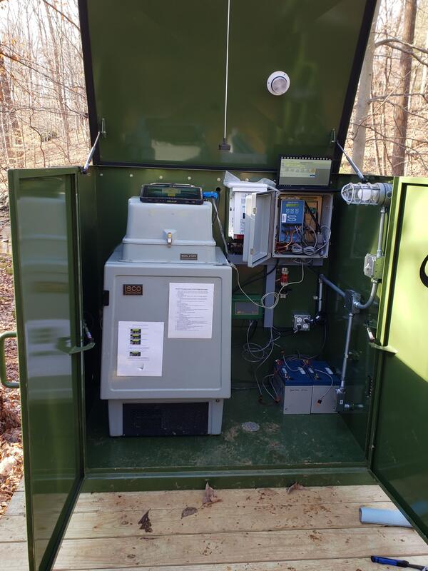
The water quality monitoring station at Dead Run. The gage house contains water quality monitoring equipment inside. Part of the Fairfax Water Resources Monitoring Network.
Images
Images intro.
Filter Total Items: 308
Gage House at Dead Run
The water quality monitoring station at Dead Run. The gage house contains water quality monitoring equipment inside. Part of the Fairfax Water Resources Monitoring Network.

Sonde Cleaning at Rivers Ridge Storm Drain, Hampton Roads
Sonde Cleaning at Rivers Ridge Storm Drain, Hampton RoadsWater quality sondes collect continuous data from stormwater monitoring sites, but can often become fouled with algae, which interferes with the sonde's ability to collect accurate data. To keep these sondes clean between field visits, remote-activated bilge pumps are used to blast the algae from the sondes.

Storm Drain at Coliseum Drive, Hampton Roads
This storm drain a Coliseum Drive is part of the Hampton Roads Regional Water Quality Monitoring Program.
This storm drain a Coliseum Drive is part of the Hampton Roads Regional Water Quality Monitoring Program.

Virginia Coastal Plain Aquifer systems
The Virginia Coastal Plain is the relatively flat region east of the fall line characterized by a wedge of coarse permeable sediments with interbedded layers of less-permeable silts and clays that thickens towards the east. The region has multiple layered aquifers, including the Potomac aquifer system.
The Virginia Coastal Plain is the relatively flat region east of the fall line characterized by a wedge of coarse permeable sediments with interbedded layers of less-permeable silts and clays that thickens towards the east. The region has multiple layered aquifers, including the Potomac aquifer system.

Principal aquifers and wells assessed in nationwide NAWQA/GAMA groundwater quality study
Principal aquifers and wells assessed in nationwide NAWQA/GAMA groundwater quality studyMap showing principal aquifers (PAs) and wells that were sampled as part of a Nationwide assessment of the quality of groundwater used for public supply.

Groundwater Monitoring Well - Franklin, Virginia
The USGS well at Franklin, Virginia (USGS 364059076544901 55B 16) constantly monitors water levels in the Potomac Aquifer and provides scientists with a record of water levels going as far
The USGS well at Franklin, Virginia (USGS 364059076544901 55B 16) constantly monitors water levels in the Potomac Aquifer and provides scientists with a record of water levels going as far

GPS tripod used in geodedic surveys of eastern Virginia
GPS tripod used in geodedic surveys of eastern VirginiaUSGS scientist Jim Duda sets up a GPS tripod in preparation for a geodetic survey on Virginia's Eastern Shore.
GPS tripod used in geodedic surveys of eastern Virginia
GPS tripod used in geodedic surveys of eastern VirginiaUSGS scientist Jim Duda sets up a GPS tripod in preparation for a geodetic survey on Virginia's Eastern Shore.

Assateague Island National Seashore
sUAS coastal Imagery collected by the Woods Hole Coastal and Marine Science Center Aerial Imaging and Mapping group (AIM) at Assateague Island National Seashore October 10-14th 2022.
sUAS coastal Imagery collected by the Woods Hole Coastal and Marine Science Center Aerial Imaging and Mapping group (AIM) at Assateague Island National Seashore October 10-14th 2022.

USGS Precipitation Gage at Little Run Elementary
Photograph of the USGS precipitation gage located at Little Run Elementary in Fairfax County. Data for this station can be found on USGS Water Data For the Nation.
Photograph of the USGS precipitation gage located at Little Run Elementary in Fairfax County. Data for this station can be found on USGS Water Data For the Nation.

Side-by-side panels to show forest harvested for timber in southwest Cumberland County, Virginia from 2014-2018
Side-by-side panels to show forest harvested for timber in southwest Cumberland County, Virginia from 2014-2018Forest harvested for timber (brown) in southwest Cumberland County, Virginia from 2014-2018.

Side-by-side panels to show forest harvested for timber for the development of solar fields in southwest Cumberland County, Virginia from 2014-2018
Side-by-side panels to show forest harvested for timber for the development of solar fields in southwest Cumberland County, Virginia from 2014-2018Forests in this area of Louisa County, Virginia were recently cleared for timber (brown) and for the development of solar fields (yellow).
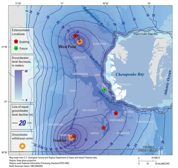
Virginia Extensometer Network
This map shows the locations of the four existing extensometers (red) in the USGS' Virginia Extensometer Network with the location of a fifth future extensometer (green). The basemap is of the Virginia Coastal Plain and shows the severity of groundwater depletion, with darker blue indicating greater groundwater depletion.
This map shows the locations of the four existing extensometers (red) in the USGS' Virginia Extensometer Network with the location of a fifth future extensometer (green). The basemap is of the Virginia Coastal Plain and shows the severity of groundwater depletion, with darker blue indicating greater groundwater depletion.

The USGS Nansemond Extensometer
The USGS Nansemond pipe extensometer (59D 39) with a total depth of 1,960 feet. Data for this site can be found on USGS Water Data for the Nation.
The USGS Nansemond pipe extensometer (59D 39) with a total depth of 1,960 feet. Data for this site can be found on USGS Water Data for the Nation.

Measuring discharge - The Glade, Reston, VA
A USGS scientist measures stream discharge at The Glade, an urban stream in Reston, Virginia.
A USGS scientist measures stream discharge at The Glade, an urban stream in Reston, Virginia.

Benthic Macroinvertebrate Sampling – Snakeden Branch, Reston, VA
Benthic Macroinvertebrate Sampling – Snakeden Branch, Reston, VAA USGS scientist samples for benthic macroinvertebrates at Snakeden Branch, Reston, VA
Benthic Macroinvertebrate Sampling – Snakeden Branch, Reston, VA
Benthic Macroinvertebrate Sampling – Snakeden Branch, Reston, VAA USGS scientist samples for benthic macroinvertebrates at Snakeden Branch, Reston, VA

Benthic Macroinvertebrate Sampling – The Glade, Reston, VA
Benthic Macroinvertebrate Sampling – The Glade, Reston, VAUSGS scientists conduct benthic macroinvertebrate sampling at The Glade in Reston, Virginia
Benthic Macroinvertebrate Sampling – The Glade, Reston, VA
Benthic Macroinvertebrate Sampling – The Glade, Reston, VAUSGS scientists conduct benthic macroinvertebrate sampling at The Glade in Reston, Virginia

Larval Dragonfly
A USGS researcher shows off a dragonfly larva found during benthic macroinvertibrate sampling in Reston, Virginia.
A USGS researcher shows off a dragonfly larva found during benthic macroinvertibrate sampling in Reston, Virginia.

Map of Potomac River basin
The study area within the Potomac River basin of eastern North America. Open circles show sample site locations on streams within the C&O Canal National Historical Park. Shaded areas show physiographic regions within Maryland from west to east as the Ridge and Valley, Blue Ridge, and Piedmont, and the stippled areas show regions of karst geology.
The study area within the Potomac River basin of eastern North America. Open circles show sample site locations on streams within the C&O Canal National Historical Park. Shaded areas show physiographic regions within Maryland from west to east as the Ridge and Valley, Blue Ridge, and Piedmont, and the stippled areas show regions of karst geology.
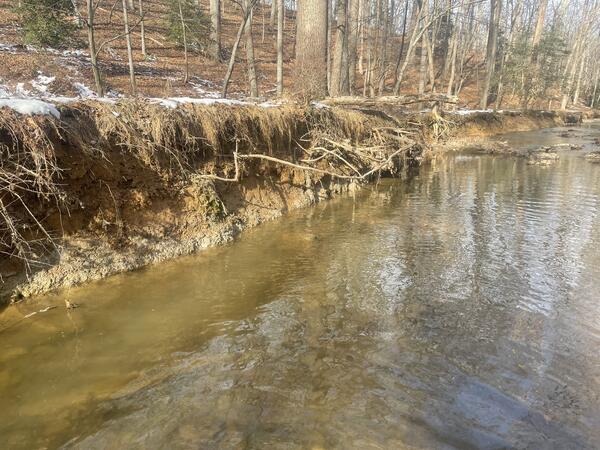
Streambank Erosion at Little Difficult Run
The water quality monitoring site at Little Difficult Run in Fairfax County, Virginia. The banks of this urban stream are eroding, contributing to elevated loads of suspended sediment to downstream water bodies. Little Difficult Run is a part of the Fairfax County Water Resources Monitoring Network.
The water quality monitoring site at Little Difficult Run in Fairfax County, Virginia. The banks of this urban stream are eroding, contributing to elevated loads of suspended sediment to downstream water bodies. Little Difficult Run is a part of the Fairfax County Water Resources Monitoring Network.
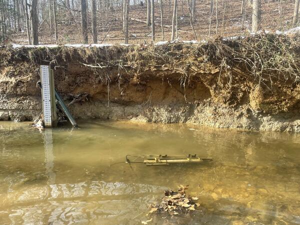
Monitoring Site at Little Difficult Run
The water quality monitoring site at Little Difficult Run in Fairfax County, Virginia. A staff gage, which is used to measure water depth, is installed on the far bank, and a submerged water quality monitoring sonde is affixed to the streambed. Little Difficult Run is a part of the Fairfax County Water Resources Monitoring Network.
The water quality monitoring site at Little Difficult Run in Fairfax County, Virginia. A staff gage, which is used to measure water depth, is installed on the far bank, and a submerged water quality monitoring sonde is affixed to the streambed. Little Difficult Run is a part of the Fairfax County Water Resources Monitoring Network.

Cedar Creek, tributary of the James River, Virginia
Cedar Creek, tributary of the James River, VirginiaCedar Creek, tributary of the James River, Virginia flows through the Natural Bridge rock formation in Gilmore Mills, Rockbridge County Virginia.
Cedar Creek, tributary of the James River, Virginia
Cedar Creek, tributary of the James River, VirginiaCedar Creek, tributary of the James River, Virginia flows through the Natural Bridge rock formation in Gilmore Mills, Rockbridge County Virginia.