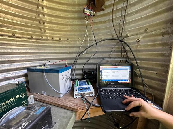
Inside the Mt. Jackson monitoring site building.
This photo was taken as a part of the Shenandoah River HABs Project.

Official websites use .gov
A .gov website belongs to an official government organization in the United States.
Secure .gov websites use HTTPS
A lock () or https:// means you’ve safely connected to the .gov website. Share sensitive information only on official, secure websites.
Inside the Mt. Jackson monitoring site building.
This photo was taken as a part of the Shenandoah River HABs Project.
Inside the Mt. Jackson monitoring site building.
This photo was taken as a part of the Shenandoah River HABs Project.
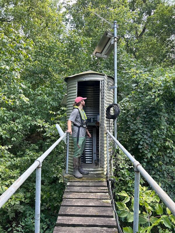
Mt. Jackson Monitoring Station, located along the North Fork Shenandoah River.
This photo was taken as a part of the Shenandoah River HABs Project.
Mt. Jackson Monitoring Station, located along the North Fork Shenandoah River.
This photo was taken as a part of the Shenandoah River HABs Project.

Deer Rapids, on the North Fork of the Shenandoah River in Virginia, during a harmful algal bloom (HAB) event. Note how green, filamentous algae coats the riverbed.
Data for this monitoring site can be found at USGS Water Data for the Nation.
Deer Rapids, on the North Fork of the Shenandoah River in Virginia, during a harmful algal bloom (HAB) event. Note how green, filamentous algae coats the riverbed.
Data for this monitoring site can be found at USGS Water Data for the Nation.

A harmful algal bloom (HAB) event in the Shenandoah River's North Fork. Note the greenish color of the water and the thick mats of stringy algae coating the riverbed.
A harmful algal bloom (HAB) event in the Shenandoah River's North Fork. Note the greenish color of the water and the thick mats of stringy algae coating the riverbed.

A harmful algal bloom (HAB) event in the North Fork Shenandoah River near Strausburg. Algae can be seen floating at the surface in mats, while filamentous algae coats the riverbed below the surface.
A harmful algal bloom (HAB) event in the North Fork Shenandoah River near Strausburg. Algae can be seen floating at the surface in mats, while filamentous algae coats the riverbed below the surface.

Clay pads are used to monitor sediment deposition in the Long Branch watershed in Fairfax, Virginia. Once installed, the amount of sediment deposited atop the clay pad can be periodically measured. This clay pad is obscured by one year's worth of sediment deposition.
Clay pads are used to monitor sediment deposition in the Long Branch watershed in Fairfax, Virginia. Once installed, the amount of sediment deposited atop the clay pad can be periodically measured. This clay pad is obscured by one year's worth of sediment deposition.

Accotink Creek is an urban creek in the Potomac watershed. Like many urban streams, it suffers from bank erosion, leading to high suspended sediment loads, steep banks, and fallen trees.
Accotink Creek is an urban creek in the Potomac watershed. Like many urban streams, it suffers from bank erosion, leading to high suspended sediment loads, steep banks, and fallen trees.

A USGS hydrotech conducts horizontally-integrated synoptic water quality sampling at Accotink Creek Near Annandale, VA.
A USGS hydrotech conducts horizontally-integrated synoptic water quality sampling at Accotink Creek Near Annandale, VA.

A USGS hydrotech uses a water quality sonde to measure conditions at Accotink Creek Near Annandale, VA. This monitoring station is part of the USGS nontidal network.
A USGS hydrotech uses a water quality sonde to measure conditions at Accotink Creek Near Annandale, VA. This monitoring station is part of the USGS nontidal network.

Photo of Blake Dudding, USGS, performing a survey on the banks of Lake Anna, Virginia
Photo of Blake Dudding, USGS, performing a survey on the banks of Lake Anna, Virginia

USGS Monitoring Station 016701405, alongside tributary and road side, Near Lake Anna, Virginia
Data for this monitoring station can be found at USGS Water Data for the Nation
USGS Monitoring Station 016701405, alongside tributary and road side, Near Lake Anna, Virginia
Data for this monitoring station can be found at USGS Water Data for the Nation

USGS Scientist Brendan Foster taking and sealing an algal sample on a dock at Lake Anna, Virginia.
USGS Scientist Brendan Foster taking and sealing an algal sample on a dock at Lake Anna, Virginia.

Deer Rapids, North Fork Shenandoah River, Virginia.
Data for this monitoring site can be found at USGS Water Data for the Nation.
Deer Rapids, North Fork Shenandoah River, Virginia.
Data for this monitoring site can be found at USGS Water Data for the Nation.

Lake Anna is a lake in Virginia impacted by Harmful Algal Blooms, or HABs. Note the greenish color of the water. This is caused by an excess of algae, some species of which could be toxic.
Lake Anna is a lake in Virginia impacted by Harmful Algal Blooms, or HABs. Note the greenish color of the water. This is caused by an excess of algae, some species of which could be toxic.

Brendan Foster, a USGS scientist, collects a water quality sample from a Lake Anna dock.
USGS scientists are exploring factors driving Harmful Algal Blooms. Learn more here.
Brendan Foster, a USGS scientist, collects a water quality sample from a Lake Anna dock.
USGS scientists are exploring factors driving Harmful Algal Blooms. Learn more here.
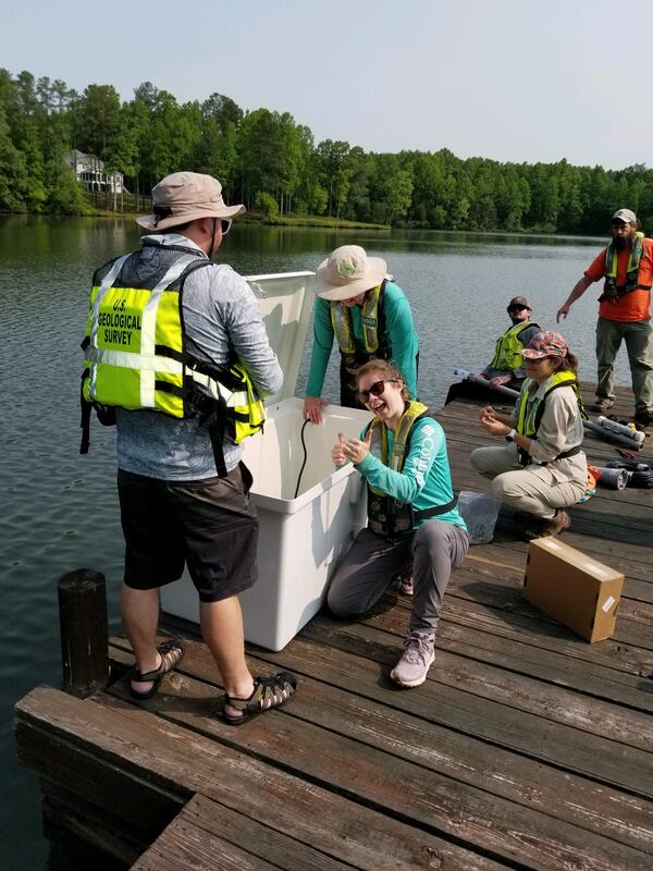
Scientists from the Virginia and West Virginia Water Science Center setting up a water quality monitoring station on Lake Anna
Scientists from the Virginia and West Virginia Water Science Center setting up a water quality monitoring station on Lake Anna

A cableway training session conducted during the Virginia and West Virginia Water Science Center's annual data summit in Lexington, Virginia. Photo is taken at a streamgage at Maury River near Buena Vista, Virginia.
Spring 2023 Photo Contest Winner: Carson Wright, People category
A cableway training session conducted during the Virginia and West Virginia Water Science Center's annual data summit in Lexington, Virginia. Photo is taken at a streamgage at Maury River near Buena Vista, Virginia.
Spring 2023 Photo Contest Winner: Carson Wright, People category

Drilling a new borehole extensometer is a delicate task.
Drilling a new borehole extensometer is a delicate task.

While drilling the 1420-foot-deep borehole for the West Point Extensometer, USGS geologists take the opportunity to learn all they can about the underlying geology. As they drill deeper, sediments are pumped out of the borehole. Geologists take samples of the sediments every 20 feet and note their composition.
While drilling the 1420-foot-deep borehole for the West Point Extensometer, USGS geologists take the opportunity to learn all they can about the underlying geology. As they drill deeper, sediments are pumped out of the borehole. Geologists take samples of the sediments every 20 feet and note their composition.

Photograph of the USGS precipitation gage located at Fairfax Middle School in Fairfax County. Data for this station can be found on USGS Water Data For the Nation.
Photograph of the USGS precipitation gage located at Fairfax Middle School in Fairfax County. Data for this station can be found on USGS Water Data For the Nation.

A USGS crest stage gage used for measuring peak flow. Part of the Fairfax County Water Resources Monitoring Network.
A USGS crest stage gage used for measuring peak flow. Part of the Fairfax County Water Resources Monitoring Network.