
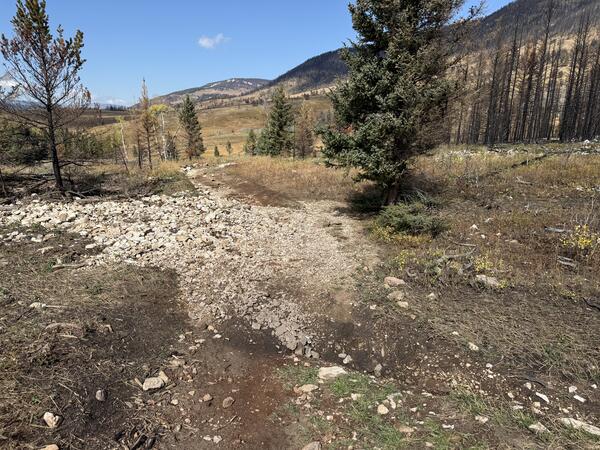
Storm runoff deposited mud, gravel, and small boulders onto Lower Dry Fork Road which runs below the steep watersheds burned by the 2024 Elk Fire near Dayton, Wyoming.
Images
Images intro.
Filter Total Items: 707
Flow deposit in the 2024 Elk Fire burn area
Storm runoff deposited mud, gravel, and small boulders onto Lower Dry Fork Road which runs below the steep watersheds burned by the 2024 Elk Fire near Dayton, Wyoming.
Burned hillslopes in the 2024 Elk Fire burn area near Dayton, Wyoming
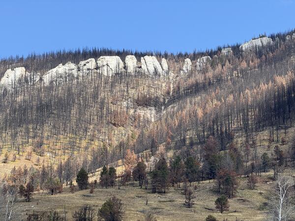
Burned hillslopes in the 2024 Elk Fire burn area near Dayton, WyomingA view looking upslope toward the burned hillsides below Dry Fork Ridge in the Bighorn National Forest within the 2024 Elk Fire burn area.
Burned hillslopes in the 2024 Elk Fire burn area near Dayton, Wyoming
Burned hillslopes in the 2024 Elk Fire burn area near Dayton, WyomingA view looking upslope toward the burned hillsides below Dry Fork Ridge in the Bighorn National Forest within the 2024 Elk Fire burn area.
Upgrading the WLWY continuous GPS site in Yellowstone National Park
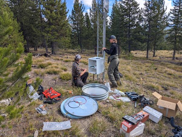
Upgrading the WLWY continuous GPS site in Yellowstone National ParkEarthScope engineers Brendan Hodge (left) and Lia Lajoie (right) perform upgrades at the WLWY (White Lake) continuous GPS station in Yellowstone National Park. The white box contains the receiver, while the barrel on the ground contains batteries. The tower holds the solar panels, as well as a cellular modem and meteorological sensors that were recently
Upgrading the WLWY continuous GPS site in Yellowstone National Park
Upgrading the WLWY continuous GPS site in Yellowstone National ParkEarthScope engineers Brendan Hodge (left) and Lia Lajoie (right) perform upgrades at the WLWY (White Lake) continuous GPS station in Yellowstone National Park. The white box contains the receiver, while the barrel on the ground contains batteries. The tower holds the solar panels, as well as a cellular modem and meteorological sensors that were recently
Map of Upper Colorado River Basin - Integrated Water Availability
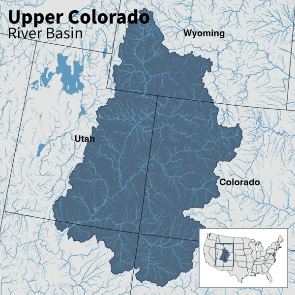
Map of Upper Colorado River Basin - Integrated Water AvailabilityMap of the Upper Colorado River Basin —referred to as an Integrated Water Science (IWS) basins—are intensively monitored study basins representing a wide range of environmental, hydrologic, and landscape settings and human stressors of water resources to improve our understanding of water availability across the Nation.
Map of Upper Colorado River Basin - Integrated Water Availability
Map of Upper Colorado River Basin - Integrated Water AvailabilityMap of the Upper Colorado River Basin —referred to as an Integrated Water Science (IWS) basins—are intensively monitored study basins representing a wide range of environmental, hydrologic, and landscape settings and human stressors of water resources to improve our understanding of water availability across the Nation.
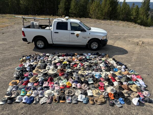
Hats collected by the Yellowstone National Park Geology Program from sensitive thermal areas in 2025
Hats collected by the Yellowstone National Park Geology Program from sensitive thermal areas in 2025Just some of the hats collected by the Yellowstone National Park Geology Program from sensitive thermal areas throughout the park in 2025. National Park Service photo by Margery Price, September 3, 2025.
USGS geologist collects a sample from a potential newly recognized lava flow along the Gibbon River, Yellowstone National Park
USGS geologist collects a sample from a potential newly recognized lava flow along the Gibbon River, Yellowstone National ParkUSGS geologist Mark Stelten collects a sample of what is potentially a newly recognized lava flow exposed along the Gibbon River. USGS photo by Nicole Thomas, September 2025.
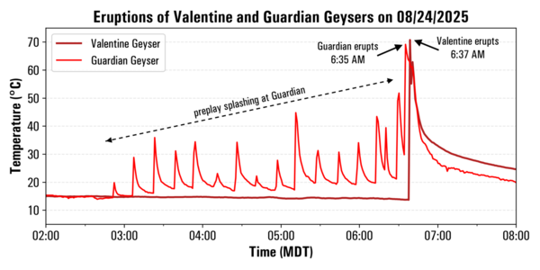
Temperature record from Valentine and Guardian Geysers, Norris Geyser Basin, Yellowstone National Park, from August 24, 2025
Temperature record from Valentine and Guardian Geysers, Norris Geyser Basin, Yellowstone National Park, from August 24, 2025Plot of temperatures measured by continuous loggers at Guardian Geyser (light red) and Valentine Geyser (dark red) on August 24, 2025. Activity at Guardian Geyser included episodic splashing for a few hours prior to the near-simultaneous eruptions of both geysers just after 6:30 a.m. MDT on this date. Data collected by Mara Reed, Yellowstone National Park.
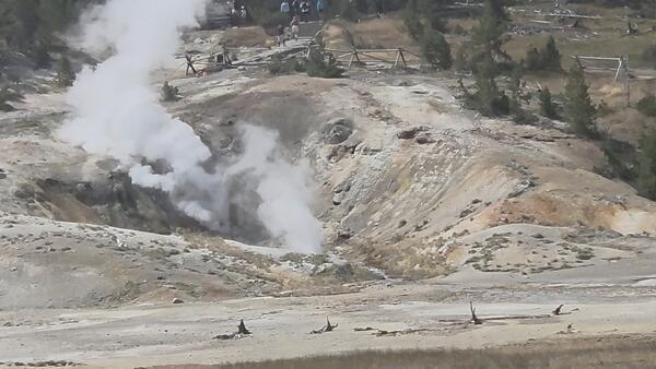
Valentine and Guardian Geysers, Norris Geyser Basin, Yellowstone National Park
Valentine and Guardian Geysers, Norris Geyser Basin, Yellowstone National ParkPhoto of Valentine Geyser and Guardian Geyser in eruption on August 7, 2025. Valentine Geyser is in the rear of the alcove, and Guardian Geyser is at the alcove’s mouth, closer to the camera. Visitors on a trail below the Norris Geyser Basin Museum can be seen at the top of the image. Photo by Carol Beverly, used with permission.
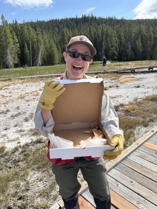
Removing trash from Geyser Hill, Yellowstone National Park
Removing trash from Geyser Hill, Yellowstone National ParkYellowstone National Park Geology Program volunteer Tara Cross smiles and shows off a pizza box found on Geyser Hill in Upper Geyser Basin. National Park Service photo by Margery Price, August 2025.
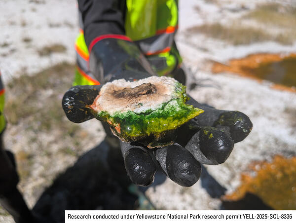
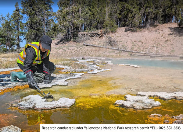
Sample of thermophilic cyanobacteria collected from a hot spring in Yellowstone’s Lower Geyser Basin
Sample of thermophilic cyanobacteria collected from a hot spring in Yellowstone’s Lower Geyser BasinA researcher holds a vibrant green sample of thermophilic cyanobacteria collected from a hot spring in Yellowstone’s Lower Geyser Basin. National Park Service photo by Samantha Hilburn, August 2025.
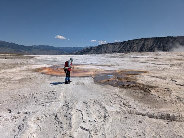
Extracting wind-blown litter from a thermal feature in Yellowstone National ark
Extracting wind-blown litter from a thermal feature in Yellowstone National arkYellowstone National Park Geology Program team member Mara Reed uses a long grabber pole to remove a park map, presumably blown from a visitor's hand or pack by the wind, from a feature in Upper Mammoth Terraces. National Park Service photo by Samantha Hilburn, August 2025.
Yellowstone National Park geology team installs safety signage near a hot spring
Yellowstone National Park geology team installs safety signage near a hot springYellowstone National Park Geology Program team member Margery Price installs a thermal danger sign near Maiden’s Grave Spring along Fountain Flat Drive. National Park Service photo by Samantha Hilburn, August 2025.
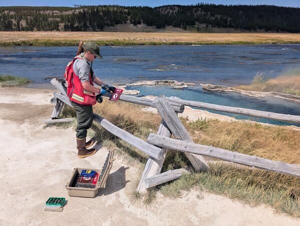
Sampling thermophilic cyanobacteria from a hot spring in Yellowstone's Lower Geyser Basin
Sampling thermophilic cyanobacteria from a hot spring in Yellowstone's Lower Geyser BasinA researcher collects a sample of thermophilic cyanobacteria from a hot spring in Yellowstone's Lower Geyser Basin. National Park Service photo by Samantha Hilburn, August 2025.
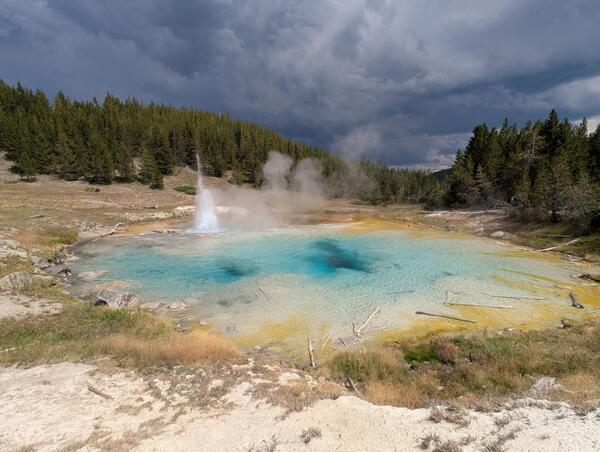
Imperial Geyser in eruption, Yellowstone National Park
Imperial Geyser in eruption, Yellowstone National ParkImperial Geyser in eruption. The geyser, which apparently formed in 1927, is located in Lower Geyser Basin, Yellowstone National Park.
Imperial Geyser in eruption, Yellowstone National Park
Imperial Geyser in eruption, Yellowstone National ParkImperial Geyser in eruption. The geyser, which apparently formed in 1927, is located in Lower Geyser Basin, Yellowstone National Park.
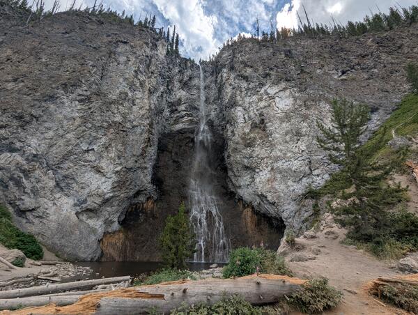
Fairy Falls, Yellowstone National Park
Fairy Falls, a 200-foot-high (60 meters) waterfall over rhyolite cliffs in the Lower Geyser Basin of Yellowstone National Park.
Fairy Falls, a 200-foot-high (60 meters) waterfall over rhyolite cliffs in the Lower Geyser Basin of Yellowstone National Park.
Debris-flow deposit in the 2024 Elk Fire burn area
Debris-flow deposit in the 2024 Elk Fire burn areaDebris-flow deposit in the 2024 Elk Fire burn area near Dayton, Wyoming is comprised of poorly sorted, mud- to boulder-sized sediment. A small amount of woody debris is intermixed with the sediment that fills channel.
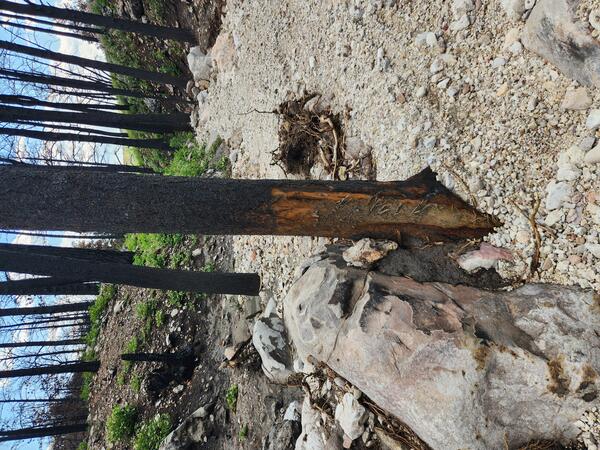
Tree damage in the 2024 Elk Fire burn area.
The bark at the base of a tree in a burned watershed in the 2024 Ek Fire burn area has been partially removed by fast-moving water and debris. This damage occurs as debris flows pass through the channel and sediment suspended in the flow scrapes bark off of trees.
The bark at the base of a tree in a burned watershed in the 2024 Ek Fire burn area has been partially removed by fast-moving water and debris. This damage occurs as debris flows pass through the channel and sediment suspended in the flow scrapes bark off of trees.
Postfire runoff in the 2024 Elk Fire buran area near Dayton, Wyoming
Postfire runoff in the 2024 Elk Fire buran area near Dayton, WyomingRunoff during a 2025 summer thunderstorm carried material downstream in this relatively small channel in the High Water Creek watershed within the Elk Fire burn area.
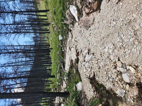
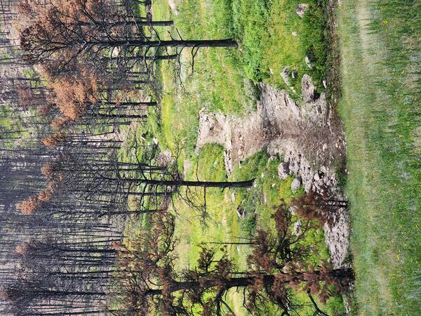
Runoff in the 2024 Elk Fire burn area
Runoff in the 2024 Elk Fire burn area. This meadow near a watershed outlet along Lower Dry Fork Road shows a shallow channel formed during Summer 2025. Although vegetation is recovering, runoff deposited mud and flattened grasses in this low-slope area.
Runoff in the 2024 Elk Fire burn area. This meadow near a watershed outlet along Lower Dry Fork Road shows a shallow channel formed during Summer 2025. Although vegetation is recovering, runoff deposited mud and flattened grasses in this low-slope area.
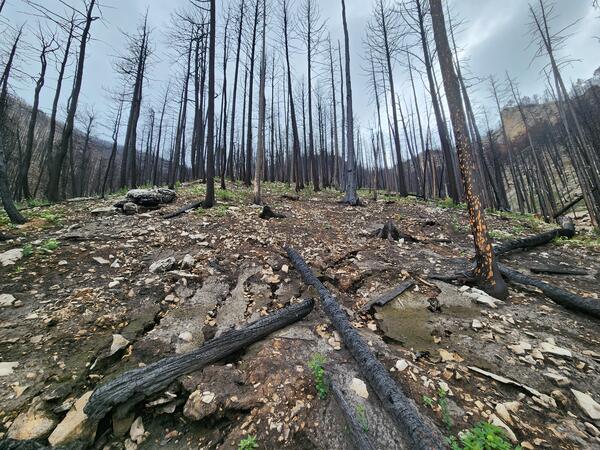
Burned hillslope in the 2024 Elk Fire burn area near Dayton, Wyoming
Burned hillslope in the 2024 Elk Fire burn area near Dayton, WyomingBurned trees and loose material cover a burned hillslope in 2024 Elk Fire burn area near Dayton, Wyoming. Rills, in the foreground formed from rainfall running off the ground surface. New green vegetation shows early signs of postfire recovery.
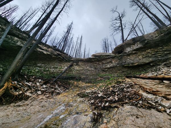
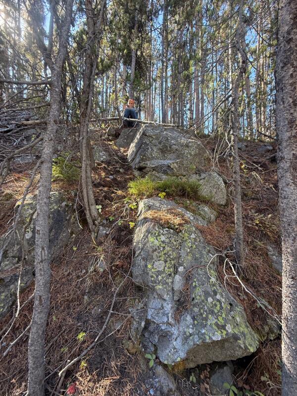
Knickpoint near the headwaters of a burned watershed in the 2024 Elk Fire burn area
Knickpoint near the headwaters of a burned watershed in the 2024 Elk Fire burn areaKnickpoint (a step-like feature in bedrock along stream channel) near the headwaters of a burned watershed in the 2024 Elk Fire burn area near Dayton, Wyoming. The exposed bedrock is heavily fractured, and loose material is visible at the base. During storms, this material can be mobilized and transported downstream.