
Rhyolite lavas in the Yellowstone Caldera younger than 631,000 years
Images
Images intro.
Filter Total Items: 708

A digital elevation map of Yellowstone Caldera
Rhyolite lavas in the Yellowstone Caldera younger than 631,000 years
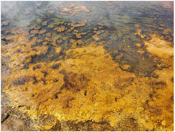
Alkaline hot spring outflow channel in the Biscuit Basin
Alkaline hot spring outflow channel in the Biscuit BasinA wide array of phototrophic microbial community textures exhibited in an alkaline (pH ~8.5) hot spring outflow channel in the Biscuit Basin, including thick mats, toadstools, ropes, and pinnacles. The differences in color are due to pigments (chlorophylls, bacteriochlorophylls, and carotenoids) produced by phototrophic microorganisms.

Sapphire Pool, in the Biscuit Basin area of the Upper Geyser Basin, Yellowstone National Park
Sapphire Pool, in the Biscuit Basin area of the Upper Geyser Basin, Yellowstone National ParkSapphire Pool, an alkaline (pH ~7.5) spring in the Biscuit Basin area of the Upper Geyser Basin, Yellowstone National Park.

Wyoming Landsat State Mosaic
Wyoming is home to the country’s first official national park–Yellowstone, the country’s first national forest–Shoshone, and the country’s first national monument–Devil’s Tower.
Capital Cheyenne
Image Source Landsat 8
Population 576,851
Wyoming is home to the country’s first official national park–Yellowstone, the country’s first national forest–Shoshone, and the country’s first national monument–Devil’s Tower.
Capital Cheyenne
Image Source Landsat 8
Population 576,851

Image of Yellowstone Lake showing location of core YL16-2C
Image of Yellowstone Lake showing location of core YL16-2CA digital elevation map of Yellowstone National Park (left) with the location of Yellowstone Lake indicated by the white box. Satellite image (right) of the study site with collection location of core YL16-2C shown by the red circle. Map was originally published in Sabrina Brown’s dissertation (2019).

Headwaters of Littlefield Creek
Headwaters of Littlefield Creek

WY-MT Water Science Center 2019 all-hands meeting
WY-MT Water Science Center 2019 all-hands meeting
WY-MT Water Science Center 2019 all-hands meeting

Alpine meadow near Two Ocean Pass, just south of Yellowstone National Park
Alpine meadow near Two Ocean Pass, just south of Yellowstone National ParkAlpine meadow near Two Ocean Pass on the Continental Divide just south of Yellowstone National Park.
Alpine meadow near Two Ocean Pass, just south of Yellowstone National Park
Alpine meadow near Two Ocean Pass, just south of Yellowstone National ParkAlpine meadow near Two Ocean Pass on the Continental Divide just south of Yellowstone National Park.

Sunset from Steamboat Lake, WY
The USGS and partners study the effects of climate change on the Greater Yellowstone Ecosystem. This sunset image was taken from Steamboat Lake, Wind River Indian Reservation, Wind River Range, Wyoming.
The USGS and partners study the effects of climate change on the Greater Yellowstone Ecosystem. This sunset image was taken from Steamboat Lake, Wind River Indian Reservation, Wind River Range, Wyoming.

Image of the north part of Yellowstone Lake from September 2, 2019
Image of the north part of Yellowstone Lake from September 2, 2019Image of the north part of Yellowstone Lake with the smoke plume from the Brimstone Fire in the distance, acquired by the YVO webcam on September 2, 2019, at 2:05 PM MDT.

The Parting of the Waters
The Parting of the Waters, looking southeast. North Two Ocean Creek splits into Atlantic Creek, flowing to the left in the photo, and Pacific Creek, flowing to the right. The wooden sign indicates that it is 3,488 miles to the Atlantic Ocean and 1,353 miles to the Pacific Ocean.
The Parting of the Waters, looking southeast. North Two Ocean Creek splits into Atlantic Creek, flowing to the left in the photo, and Pacific Creek, flowing to the right. The wooden sign indicates that it is 3,488 miles to the Atlantic Ocean and 1,353 miles to the Pacific Ocean.

Research raft on Spider Lake, WY
The USGS and partners study the effects of climate change on the Greater Yellowstone Ecosystem. This image shows a research raft on Spider Lake, Wind River Indian Reservation, Wind River Range, Wyoming.
The USGS and partners study the effects of climate change on the Greater Yellowstone Ecosystem. This image shows a research raft on Spider Lake, Wind River Indian Reservation, Wind River Range, Wyoming.

Aerial view of new thermal area near Tern Lake, Yellowstone.
Aerial view of new thermal area near Tern Lake, Yellowstone.Aerial view of the new thermal area, in the center left. The existing Tern Lake thermal area is the bright white patch of ground in the upper middle part of the image. West Tern Lake is in the lower right. Research conducted under NPS Geology Programs Milestones Permit 2016-9.

Cirque of the Towers in the Wind River Range, Wyoming
Cirque of the Towers in the Wind River Range, WyomingView of the Cirque of the Towers in the Wind River Range, with Pingora Peak in the center. The Bull Lake and Pinedale glaciations carved this valley by steepening and smoothing its granite walls. Image captured while descending from Texas Pass. Image view is toward the southwest. USGS photo by Stanley Mordensky, August 2019.

Head and mouthparts of the wetsalts tiger beetle
A closeup of the head and mouthparts of the wetsalts tiger beetle, a voracious predator in Yellowstone. Photo by Robert K. D. Peterson, 2019.
A closeup of the head and mouthparts of the wetsalts tiger beetle, a voracious predator in Yellowstone. Photo by Robert K. D. Peterson, 2019.

Eruption of Steamboat Geyser on July 18, 2019
Steamboat Geyser erupts in the golden light of sunrise on July 18th, 2019. The water-dominated part of a Steamboat eruption usually lasts anywhere from 3 to 90 minutes. Afterwards, a steam-dominated phase continues for many hours.
Steamboat Geyser erupts in the golden light of sunrise on July 18th, 2019. The water-dominated part of a Steamboat eruption usually lasts anywhere from 3 to 90 minutes. Afterwards, a steam-dominated phase continues for many hours.

Sealing MBARI Environmental Sample Processor into its housing
Sealing MBARI Environmental Sample Processor into its housingSealing MBARI Environmental Sample Processor into its housing
Sealing MBARI Environmental Sample Processor into its housing
Sealing MBARI Environmental Sample Processor into its housingSealing MBARI Environmental Sample Processor into its housing

"Bobby socks" trees near the parking lot of Fountain Paint Pots in the Lower Geyser Basin, Yellowstone National Park
"Bobby socks" trees near the parking lot of Fountain Paint Pots in the Lower Geyser Basin, Yellowstone National ParkDead lodgepole pine trees near the parking lot of Fountain Paint Pots in the Lower Geyser Basin. The trees look as if they are wearing white socks; hence, the name, “bobby socks trees.” The dead trees soak up the silica-rich water, turning the lower portion of the trees white.

Images of snow algae and snow cyanobacteria on snow fields in the Beartooth Mountains of Wyoming and Montana
Images of snow algae and snow cyanobacteria on snow fields in the Beartooth Mountains of Wyoming and MontanaImages of snow algae and snow cyanobacteria on snow fields in the Beartooth Mountains near the Beartooth Pass Summit (elevation 10,947 ft/3,368 m) on Highway 212. Top left shows a typical pink snow algae bloom on a patch of snow, and top right shows the snow algae bloom scraped off the snow surface with a rock hammer.

Sampling Big Sandy River below Farson, WY
Sampling Big Sandy River below Farson, WY

Working records in 2019 using printout from 1935
Working records in 2019 using printout from 1935