
Giantess Geyser in eruption at approximately 10:00 AM MDT on August 26, 2020. Old Faithful is erupting in the center background.
Images
Images intro.
Filter Total Items: 708

Giantess Geyser in eruption on August 26, 2020
Giantess Geyser in eruption at approximately 10:00 AM MDT on August 26, 2020. Old Faithful is erupting in the center background.

Tree rings in a Rocky Mountain Juniper, Yellowstone National Park
Tree rings in a Rocky Mountain Juniper, Yellowstone National ParkA scanned image of Rocky Mountain juniper deadwood sample GGR100 collected in the northern part of Yellowstone National Park under permit YELL-5582. The full length of this sample covers the time period 723-1792 CE.
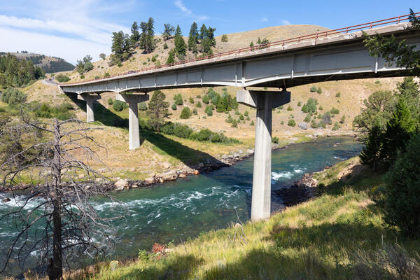
1960s-era bridge over the Yellowstone River near Tower Junction
1960s-era bridge over the Yellowstone River near Tower JunctionThe current bridge across the Yellowstone River near Tower Junction. The bridge was constructed in the early 1960s and has structural problems that require it to be replaced. The bridge will be removed once the new Yellowstone River Bridge is completed (scheduled for 2026). Photo by Jacob Frank (Yellowstone National Park) on August 17, 2020.

Sapphire Pool, Yellowstone National Park
Sapphire Pool, in Biscuit Basin, steams on a stormy morning. A few “biscuits” remain along the pool’s southern edge (center right of photo) – violent geyser eruptions destroyed hundreds of the features when the pool’s plumbing system changed after being jarred by the 1959 Hebgen Lake earthquake. National Park Service photo by Jacob W. Frank, July 20, 2020.
Sapphire Pool, in Biscuit Basin, steams on a stormy morning. A few “biscuits” remain along the pool’s southern edge (center right of photo) – violent geyser eruptions destroyed hundreds of the features when the pool’s plumbing system changed after being jarred by the 1959 Hebgen Lake earthquake. National Park Service photo by Jacob W. Frank, July 20, 2020.

Panorama of Hayden Valley, Yellowstone National Park
Panorama of Hayden Valley, Yellowstone National ParkPanoramic photo of Hayden Valley looking east toward the Yellowstone River from the Mary Mountain trail.
Panorama of Hayden Valley, Yellowstone National Park
Panorama of Hayden Valley, Yellowstone National ParkPanoramic photo of Hayden Valley looking east toward the Yellowstone River from the Mary Mountain trail.

Streamgage datum surveying for Snake River abv reservoir nr Alpine, WY
Streamgage datum surveying for Snake River abv reservoir nr Alpine, WYUSGS employee surveys streamgage datum for the Snake River near Alpine, Wyoming to ensure real-time stage and streamflow data on the web are accurate.
Streamgage datum surveying for Snake River abv reservoir nr Alpine, WY
Streamgage datum surveying for Snake River abv reservoir nr Alpine, WYUSGS employee surveys streamgage datum for the Snake River near Alpine, Wyoming to ensure real-time stage and streamflow data on the web are accurate.

Photo of volcaniclastic units of the Absaroka volcanic province in northeastern Yellowstone National Park
Photo of volcaniclastic units of the Absaroka volcanic province in northeastern Yellowstone National ParkPhoto of geologic units of the Absaroka volcanic province in northeastern Yellowstone National Park that shows volcaniclastic sandstones grading up into a conglomerate, followed by another sequence of sandstone to conglomerate. These repeating layers of the same-looking material make it difficult to assign them to a specific volcanic group.

Absaroka Mountains in northeastern Yellowstone National Park
Absaroka Mountains in northeastern Yellowstone National ParkA view into the Absaroka Mountains in northeastern Yellowstone National Park. While the Absarokas of today look a little different due to glacial activity, these are the same mountains that existed over the last 53 million years, well before the arrival of the Yellowstone hot spot.
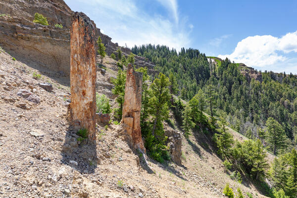
Standing petrified (silicified) trees on Specimen Ridge in northeastern Yellowstone National Park.
Standing petrified (silicified) trees on Specimen Ridge in northeastern Yellowstone National Park.Two standing petrified (silicified) trees on Specimen Ridge in northeastern Yellowstone National Park. Photo by Jacob W. Frank, Yellowstone National Park (https://www.flickr.com/photos/yellowstonenps/50016729252).

Petrified trees on Specimen Ridge, Yellowstone National Park
Petrified trees on Specimen Ridge, Yellowstone National ParkPetrified trees on Specimen Ridge, Yellowstone National Park. NPS photo by Jake Frank, June 13, 2020.
Petrified trees on Specimen Ridge, Yellowstone National Park
Petrified trees on Specimen Ridge, Yellowstone National ParkPetrified trees on Specimen Ridge, Yellowstone National Park. NPS photo by Jake Frank, June 13, 2020.

Streamflow measurement in S Fk Spread Creek, WY (13012475)
Streamflow measurement in S Fk Spread Creek, WY (13012475)Streamflow measurement in S Fk Spread Creek, WY (13012475)
Streamflow measurement in S Fk Spread Creek, WY (13012475)
Streamflow measurement in S Fk Spread Creek, WY (13012475)Streamflow measurement in S Fk Spread Creek, WY (13012475)

Little Wind River Ice Measurement
Equipment is dropped through the holes drilled in the ice on the Little Wind River near Riverton to measure streamflow.
Equipment is dropped through the holes drilled in the ice on the Little Wind River near Riverton to measure streamflow.

Winter Streamflow Measurement
Stream stage is still accurately measured by equip under ice, and fluctuates a fair amount due to ice damming and accumulation. Streamflow, however, during most of the winter is typically quite stable.
Stream stage is still accurately measured by equip under ice, and fluctuates a fair amount due to ice damming and accumulation. Streamflow, however, during most of the winter is typically quite stable.

Drilling Holes Through the Ice
Stream stage is still accurately measured by equip under ice, and fluctuates a fair amount due to ice damming and accumulation. Streamflow, however, during most of the winter is typically quite stable.
Stream stage is still accurately measured by equip under ice, and fluctuates a fair amount due to ice damming and accumulation. Streamflow, however, during most of the winter is typically quite stable.

Snowmobile Training Line-up
Lining up to finish our Snowmobile Safety Training class. Many of the roads we drive trucks on in the summer are inaccessible in the winter, so we must load up a machine.
Lining up to finish our Snowmobile Safety Training class. Many of the roads we drive trucks on in the summer are inaccessible in the winter, so we must load up a machine.

Annie Carlson, Research Permitting Coordinator for Yellowstone National Park during 2017–2023, during a winter ski expedition in the park
Annie Carlson, Research Permitting Coordinator for Yellowstone National Park during 2017–2023, during a winter ski expedition in the parkAnnie Carlson, Research Permitting Coordinator for Yellowstone National Park during 2017–2023, during a winter ski expedition in the park. National Park Service photo by Jon Nicholson, January 2020.

Sabrina Brown collecting samples from Yellowstone Lake core YL16-2C
Sabrina Brown collecting samples from Yellowstone Lake core YL16-2CSabrina Brown collecting samples from Yellowstone Lake core YL16-2C at the National Lacustrine Core Facility (LacCore) at the University of Minnesota.
Sabrina Brown collecting samples from Yellowstone Lake core YL16-2C
Sabrina Brown collecting samples from Yellowstone Lake core YL16-2CSabrina Brown collecting samples from Yellowstone Lake core YL16-2C at the National Lacustrine Core Facility (LacCore) at the University of Minnesota.

Box diagram and map showing sources and fate of geothermal solutes in the Yellowstone River
Box diagram and map showing sources and fate of geothermal solutes in the Yellowstone RiverThe Yellowstone River is divided into five reaches (labeled and color-coded): Yellowstone Lake, Hayden Valley, Grand Canyon of the Yellowstone, Tower–Gardner, and Mammoth. Monitoring stations (yellow dots on map) between each reach of the river reaches allow geochemists to measure river composition and then determine the sources of chloride (Cl) and other solu

Map showing ice cover in the Yellowstone region
Map showing ice cover in the Yellowstone region. Light shaded areas bounded by black and red lines indicate areas covered during the Pinedale (about 20,000-15,000 years ago) and Bull Lake (about 150,000 years ago) glaciations, respectively. Blue lines are contours in thousands of feet on the maximum reconstructed Pinedale glacier surface.
Map showing ice cover in the Yellowstone region. Light shaded areas bounded by black and red lines indicate areas covered during the Pinedale (about 20,000-15,000 years ago) and Bull Lake (about 150,000 years ago) glaciations, respectively. Blue lines are contours in thousands of feet on the maximum reconstructed Pinedale glacier surface.

Small acidic hot spring in the Gibbon Geyser Basin of Yellowstone National Park
Small acidic hot spring in the Gibbon Geyser Basin of Yellowstone National ParkAn unnamed small acidic (pH ~3) hot spring (with a temperature of about 55°C at the source) in the Gibbon Geyser Basin of Yellowstone National Park. The yellow region is due to the precipitation of sulfur by sulfide-oxidizing chemotrophic microorganisms.
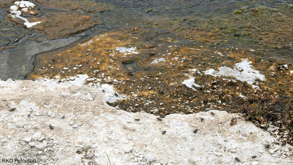
Adult tiger beetles near Midway Geyser Basin, Yellowstone National Park
Adult tiger beetles near Midway Geyser Basin, Yellowstone National ParkSeveral adult wetsalts tiger beetles hunting and basking on and around an alkaline hot spring near Midway Geyser Basin in Yellowstone National Park. Photo by Robert K. D. Peterson, 2019.