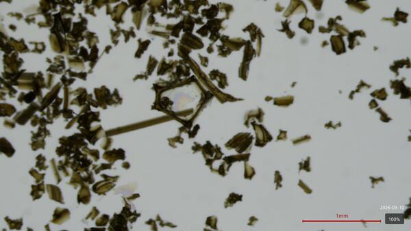
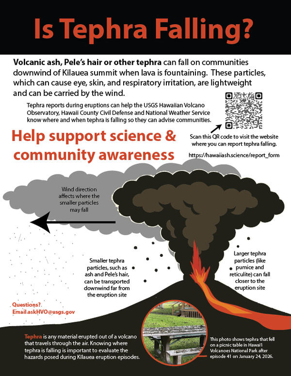
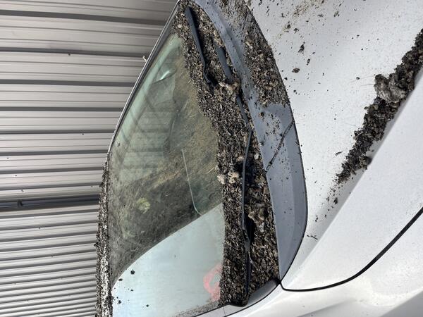
Strands of Pele's Hair collect in low-lying areas near Keanakākoʻi Overlook in Hawaiʻi Volcanoes National Park. USGS photo by K. Mulliken.
Images
Kīlauea images of eruptive activity, field work, and more.
Strands of Pele's Hair collect in low-lying areas near Keanakākoʻi Overlook in Hawaiʻi Volcanoes National Park. USGS photo by K. Mulliken.
June 29, 2025 — Episode 27 at the summit of Kīlauea
June 29, 2025 — Episode 27 at the summit of KīlaueaVisitors near the Keanakākoʻi Overlook in Hawaiʻi Volcanoes National Park view lava fountaining during episode 27 of the ongoing Kīlauea summit eruption on June 29. Approximately 1.6 billion gallons (8.1 million cubic yards, 6.2 million cubic meters) of lava erupted during the sustained fountaining phase of episode 27.
June 29, 2025 — Kīlauea lava fountain and koaʻe kea
June 29, 2025 — Kīlauea lava fountain and koaʻe keaA koaʻe kea (white-tailed tropicbird) flies near the lava fountain during episode 27 of the ongoing Kīlauea summit eruption in Halemaʻumaʻu. These birds are often visible in the vicinity of Kaluapele (Kīlauea summit caldera), as they nest in the walls of the caldera. USGS photo by K. Mulliken.
From the south rim of Kaluapele (Kīlauea summit caldera), the growing tephra cone downwind of the ongoing eruption site in Halemaʻumaʻu is easily visible. On June 29, visitors gathered along the rim near Keanakākoʻi Overlook within Hawaiʻi Volcanoes National Park to view lava fountaining associated with episode 27. USGS photo by K. Mulliken.
This near-vertical view into the north vent within Halema‘uma‘u crater was captured during a USGS Hawaiian Volcano Observatory UAS (uncrewed aircraft systems) flight on June 26, 2025. The aircraft was about 150 m (500 ft) above the vent, with north oriented to the upper left in this view.
lava flow and tephra accumulation at Kīlauea volcano associated with episodes 23 (left) and 24 (right) of the ongoing eruption in Halemaʻumaʻu
lava flow and tephra accumulation at Kīlauea volcano associated with episodes 23 (left) and 24 (right) of the ongoing eruption in HalemaʻumaʻuThese maps show lava flow and tephra accumulation at Kīlauea volcano associated with episodes 23 (left) and 24 (right) of the ongoing eruption in Halemaʻumaʻu that started on December 23, 2024, using data recorded by the Italian Space Agency's (ASI) COSMO-SkyMed Second Generation satellite constellation.
Kīlauea episodic eruption in Halemaʻumaʻu - growth of the tephra cone through 26 episodes
Kīlauea episodic eruption in Halemaʻumaʻu - growth of the tephra cone through 26 episodesThis animated GIF shows a timelapse sequence consisting of one image every several days between December 25, 2024, and June 20, 2025. The photos were taken from the northern rim of the caldera, near Uēkahuna overlook and the view is south towards the ongoing eruption site in Halemaʻumaʻu.
June 26, 2025 — UAS monitoring/mapping flights at Kīlauea summit
June 26, 2025 — UAS monitoring/mapping flights at Kīlauea summitOn June 26, the USGS Hawaiian Volcano Observatory conducted a UAS (uncrewed aircraft systems) mission to monitor the ongoing Kīlauea summit eruption and map its tephra deposits. Here, a geologist prepares for a flight from former Crater Rim Drive within the closed portion of Hawai‘i Volcanoes National Park.
June 24, 2025 — Kīlauea monitoring network fieldwork
June 24, 2025 — Kīlauea monitoring network fieldworkUSGS Hawaiian Volcano Observatory physical science technicians leave the field after installing two webcams and a continuous laser at the summit of Kīlauea, to help monitor the ongoing lava fountains. The landscape here is now covered by a thick carpet of tephra from the recent lava fountaining episodes, changing much of the appearance of the western caldera rim.
June 24, 2025 — Kīlauea caldera monitoring equipment
June 24, 2025 — Kīlauea caldera monitoring equipmentThe V1cam (far right), KWcam, F1cam, and continuous laser rangefinder are perched on the northwest rim of Halemaʻumaʻu crater. This monitoring equipment are powered by a series of solar panels and battery banks (visible in the background of the photo), all of which are installed with permission from Hawaiʻi Volcanoes National Park. USGS photo by M.
June 24, 2025 — Reinstalling KWcam and F1cam at Kīlauea summit
June 24, 2025 — Reinstalling KWcam and F1cam at Kīlauea summitThe KWcam, F1cam, and laser rangefinder have been co-located with the V1cam on the western rim of Kaluapele, Kīlauea summit caldera. These instruments will provide additional monitoring for the ongoing episodic Kīlauea summit eruption. USGS photo by M. Warren.
June 24, 2025 — Reinstalling KWcam, F1cam, and laser rangefinder at Kīlauea summit
June 24, 2025 — Reinstalling KWcam, F1cam, and laser rangefinder at Kīlauea summitOn June 24, USGS Hawaiian Volcano Observatory staff reinstalled the KWcam, F1cam, and laser rangefinder on the rim of Kaluapele, Kīlauea summit caldera. These instruments had been removed from the field in March 2025 as they were within an area impacted by tephra fallout from the ongoing eruption in Halemaʻumaʻu at the summit of Kīlauea.
June 20, 2025 — Lava fountaining during episode 26 at Kīlauea summit
June 20, 2025 — Lava fountaining during episode 26 at Kīlauea summitThe appearance of layers in the fountains represents discrete pulses at the base of the fountain, highlighting the dynamic nature of lava exiting the vent. The fountain supplied lava into channels that flowed north along the edge of the crater floor, into the eastern crater. USGS photo by M. Patrick.
Episode 26 lava fountaining at the summit of Kīlauea. The episode was dominated by fountaining from the north vent, and reached over 350 m (1150 feet). USGS photo.
June 20, 2025 — Lava flowing from the north vent during episode 26 on Kīlauea
June 20, 2025 — Lava flowing from the north vent during episode 26 on KīlaueaA view of the complex flow of lava exiting the north vent crater at Kīlauea summit during episode 26 of the ongoing eruption. USGS photo by M. Patrick.
June 20, 2025 — Lava fountaining during episode 26 at Kīlauea summit
June 20, 2025 — Lava fountaining during episode 26 at Kīlauea summitEpisode 26 of lava fountaining during the ongoing Kīlauea summit eruption began just after midnight, on June 20, and reached heights of over 300 meters (1000 feet).
June 20, 2025 — Lava fountaining at Kīlauea during episode 26
June 20, 2025 — Lava fountaining at Kīlauea during episode 26A USGS Hawaiian Volcano Observatory geologist collects video and makes observations of lava fountain behavior on the western caldera rim during the morning on June 20. USGS photo by M. Patrick.
June 20, 2025 — Measuring the growing tephra deposit on Kīlauea
June 20, 2025 — Measuring the growing tephra deposit on KīlaueaA USGS geologist surveys the height of the new tephra cone formed by the recent lava fountaining episodes at the summit of Kīlauea. This tephra cone now towers over, and covers, Crater Rim Drive, which has been closed to the public since 2008.
June 18, 2025 — Kīlauea eruptive pause before episode 26
June 18, 2025 — Kīlauea eruptive pause before episode 26Tephra deposits from the recent lava fountaining at Kīlauea summit have blanketed the western caldera rim, killing much of the vegetation in this area. Nevertheless, some plants are starting to sprout up again through the cinder.
June 18, 2025 — Kīlauea eruptive pause before episode 26
June 18, 2025 — Kīlauea eruptive pause before episode 26Cycles of gas pistoning were observed in the north vent, at Kīlauea summit, by USGS Hawaiian Volcano Observatory geologists looking down upon the vent from the caldera rim on June 18. The peak of each cycle produced loud jetting sounds and a brief glimpse of spatter, but the lava column was not visible and no lava flows were produced. USGS photo by M. Patrick.
June 18, 2025 — Kīlauea eruptive pause before episode 26
June 18, 2025 — Kīlauea eruptive pause before episode 26Lava fountaining remained paused on Wednesday, June 18, nearly a week after episode 25 produced impressive lava fountains at Kīlauea summit. HVO geologists on the rim observed cycles of gas-pistoning in the north vent, associated with a small amount of visible spatter and loud jetting sounds. USGS photo by M. Patrick.