
This image shows the spectral bandpasses for the sensors on all Landsat satellites.
Images
Check out the images used on the EROS Cal/Val Center of Excellence (ECCOE) Web Site.
Filter Total Items: 26
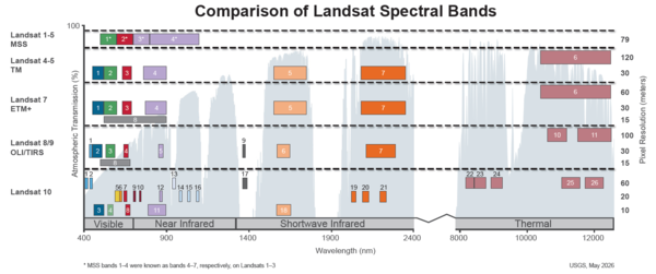
Spectral Bandpasses for all Landsat Sensors
This image shows the spectral bandpasses for the sensors on all Landsat satellites.
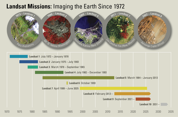
Landsat Missions Timeline
In a September 21, 1966 press release, Secretary of the Interior Stewart Udall announced that the DOI was launching "Project EROS (Earth Resources Observation Satellites)." Udall's vision was to observe the Earth for the benefit of all.
In a September 21, 1966 press release, Secretary of the Interior Stewart Udall announced that the DOI was launching "Project EROS (Earth Resources Observation Satellites)." Udall's vision was to observe the Earth for the benefit of all.
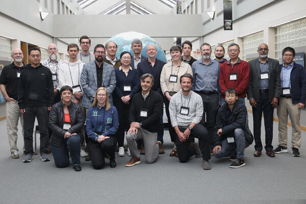
2026-2030 Landsat Science Team
The 2026-2030 Landsat Science Team met for their first in-person meeting May 5-7, 2026 at the USGS EROS Center.
The 2026-2030 Landsat Science Team met for their first in-person meeting May 5-7, 2026 at the USGS EROS Center.
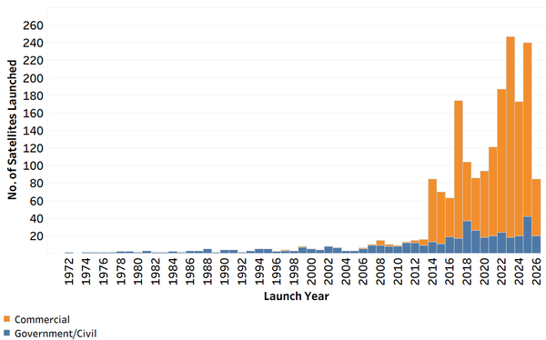
Number of Commercial, Government-Civil Earth Observing Satellites Launched
Number of Commercial, Government-Civil Earth Observing Satellites LaunchedThis chart shows the number of commercial and government/civil Earth observing satellites launched each year since 1972. This information is updated quarterly.
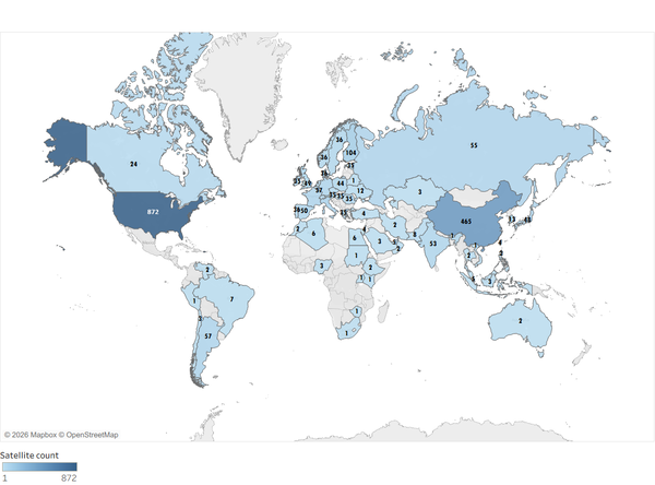
Countries with Earth Observing Satellites
The numbers on this map indicate the number of commercial and government/civil Earth observing satellites launched by the highlighted countries. This image is updated quarterly.
The numbers on this map indicate the number of commercial and government/civil Earth observing satellites launched by the highlighted countries. This image is updated quarterly.

JACIE 2027 Save the Date
JACIE 2027 Workshop will be held April 5-9, 2027 at the USGS Headquarters in Reston, Virginia.
JACIE 2027 Workshop will be held April 5-9, 2027 at the USGS Headquarters in Reston, Virginia.

JACIE 2026 Workshop Save the Date
JACIE 2026 Workshop Save the Date
Visit the JACIE 2026 Workshop webpage to keep up with information about the April 2026 meeting.
JACIE 2026 Workshop Save the Date
Visit the JACIE 2026 Workshop webpage to keep up with information about the April 2026 meeting.

The BigMAC Exercise Site
This picture is the site of the Big Multi-Agency Campaign (BigMAC), a comprehensive field exercise aimed at assessing current technologies that might be used for validation of surface products derived from satellite imagery, The exercise was held in Brookings, South Dakota in August 2021.
This picture is the site of the Big Multi-Agency Campaign (BigMAC), a comprehensive field exercise aimed at assessing current technologies that might be used for validation of surface products derived from satellite imagery, The exercise was held in Brookings, South Dakota in August 2021.

JACIE 2025 Workshop Attendees
The JACIE 2025 Workshop in-person attendees are shown in this picture. The Workshop was held April 7-11, 2025.
The JACIE 2025 Workshop in-person attendees are shown in this picture. The Workshop was held April 7-11, 2025.

Spatial Resolution Digital Imagery Guideline
This Spatial Resolution Digital Imagery Guideline was developed by Innovative and Imaging Research (I2R) for the USGS. This guide demonstrates how certain image specification parameters affect spatial resolution.
This Spatial Resolution Digital Imagery Guideline was developed by Innovative and Imaging Research (I2R) for the USGS. This guide demonstrates how certain image specification parameters affect spatial resolution.

Landsat Ground Station Operators Working Group 52 Meeting Attendees
Landsat Ground Station Operators Working Group 52 Meeting AttendeesThe attendees of the Landsat Ground Station Operators Working Group (LGSOWG) #52 meeting in Canberra, Australia in November 2024.
Visit this USGS webpage to learn more about LGSOWG #52.

JACIE 2025 Workshop deadlines
The JACIE 2025 Workshop will be held April 7-11, 2025 at USGS Headquarters in Reston, Virginia. This graphic displays the deadlines for the workshop components.
Visit the JACIE 2025 Workshop webpage to learn more about the workshop.
The JACIE 2025 Workshop will be held April 7-11, 2025 at USGS Headquarters in Reston, Virginia. This graphic displays the deadlines for the workshop components.
Visit the JACIE 2025 Workshop webpage to learn more about the workshop.

JACIE 2025 Workshop Save the Date
JACIE 2025 will be held April 7 - 11, 2025 at USGS Headquarters in Reston, Virginia.
Annual JACIE Workshops are sponsored by government agencies and allow remote sensing experts to discuss system capabilities, calibration, and the impacts of data quality on various applications.
Highlights of JACIE Workshops include:

Railroad Valley Playa
The Railroad Valley Playa, located in east central Nevada, measures about 80 miles long and nearly 20 miles wide, and is a vast and wide-open landscape.
The Railroad Valley Playa, located in east central Nevada, measures about 80 miles long and nearly 20 miles wide, and is a vast and wide-open landscape.
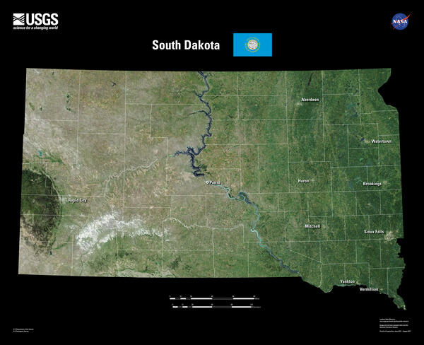
South Dakota Landsat 8 Mosaic
South Dakota is home to the fabled “Black Hills.” Seen from a distance, these pine-covered hills, rising several thousand feet above the surrounding prairie, appear black.
South Dakota is home to the fabled “Black Hills.” Seen from a distance, these pine-covered hills, rising several thousand feet above the surrounding prairie, appear black.

Landsat 9 Image of White Sands National Park
The Operational Land Imager (OLI) onboard the Landsat 9 satellite captured this image of the White Sands National Park on May 13, 2024.
The Operational Land Imager (OLI) onboard the Landsat 9 satellite captured this image of the White Sands National Park on May 13, 2024.

Ivanpah Playa Test Site
The Ivanpah Playa test site is a dry lakebed located in the Mohave Desert along the border of California and Nevada.
The Ivanpah Playa test site is a dry lakebed located in the Mohave Desert along the border of California and Nevada.

Baotou Sand Test Site
The Baotou Sand Test Site was established to assess the radiometric and spectral performance of high spatial resolution sensor payloads on airborne and satellite platforms. Located at Urad Qianqi, Inner Mongolia in northern China, the site is ∼1270 meters (m) above sea level. The site
The Baotou Sand Test Site was established to assess the radiometric and spectral performance of high spatial resolution sensor payloads on airborne and satellite platforms. Located at Urad Qianqi, Inner Mongolia in northern China, the site is ∼1270 meters (m) above sea level. The site

Keeping Satellite Data Accurate and Consistent
The EROS Calibration/Validation (Cal/Val) Center of Excellence (ECCOE) compares Landsat and other remotely sensed data to known reference points on the ground to ensure consistency - a process called calibration and validation.
The EROS Calibration/Validation (Cal/Val) Center of Excellence (ECCOE) compares Landsat and other remotely sensed data to known reference points on the ground to ensure consistency - a process called calibration and validation.
JACIE image
This image displays the agencies involved in Joint Agency Commercial Imagery Evaluation (JACIE).
This image displays the agencies involved in Joint Agency Commercial Imagery Evaluation (JACIE).

Uncrewed Aerial System Composite Image
This Uncrewed Aerial System Composite Image is an example of 3-dimensional data capture technology.
This Uncrewed Aerial System Composite Image is an example of 3-dimensional data capture technology.