A melanistic (all dark) Common Murre flies above the Gull Island breeding colony in Kachemak Bay, Alaska, 2018. See related paper published in the Marine Ornithology: Journal of Seabird Research and Conservation at: http://www.marineornithology.org/PDF/50_2/50_2_225-227.pdf.
Images
Browse images from a wide range of science topics covered by USGS. All items in this gallery are considered public domain unless otherwise noted.
A melanistic (all dark) Common Murre flies above the Gull Island breeding colony in Kachemak Bay, Alaska, 2018. See related paper published in the Marine Ornithology: Journal of Seabird Research and Conservation at: http://www.marineornithology.org/PDF/50_2/50_2_225-227.pdf.
A melanistic (all dark) Common Murre holds a display fish at its breeding site on Gull Island in Kachemak Bay, Alaska, 2019. See related paper published in the Marine Ornithology: Journal of Seabird Research and Conservation at: http://www.marineornithology.org/PDF/50_2/50_2_225-227.p
Role of Diet and Food Intake Affecting Polar Bear Population Dynamics in Southern Beaufort Sea
Role of Diet and Food Intake Affecting Polar Bear Population Dynamics in Southern Beaufort SeaThis is a graphical abstract for a publication by the USGS and collaborators that examines the role of diet and food intake affecting polar bear population dynamics. Polar bears consume diets consisting of high proportions of marine mammal blubber that they access from the sea ice.
Role of Diet and Food Intake Affecting Polar Bear Population Dynamics in Southern Beaufort Sea
Role of Diet and Food Intake Affecting Polar Bear Population Dynamics in Southern Beaufort SeaThis is a graphical abstract for a publication by the USGS and collaborators that examines the role of diet and food intake affecting polar bear population dynamics. Polar bears consume diets consisting of high proportions of marine mammal blubber that they access from the sea ice.
Synthetic Aperture Radar (SAR) satellite images of Pacific walruses
Synthetic Aperture Radar (SAR) satellite images of Pacific walrusesFigure comparing Synthetic Aperture Radar (SAR) satellite images of Pacific walruses on a terrestrial haulout near Point Lay, Alaska, as collected by four different SAR instruments possessing different spatial resolution capabilities (Sentinel-1, Radarsat-2, TerraSAR-X, and Capella Space).
Synthetic Aperture Radar (SAR) satellite images of Pacific walruses
Synthetic Aperture Radar (SAR) satellite images of Pacific walrusesFigure comparing Synthetic Aperture Radar (SAR) satellite images of Pacific walruses on a terrestrial haulout near Point Lay, Alaska, as collected by four different SAR instruments possessing different spatial resolution capabilities (Sentinel-1, Radarsat-2, TerraSAR-X, and Capella Space).
Tributary of Kugururok River, Noatak National Park and Preserve, Alaska
Tributary of Kugururok River, Noatak National Park and Preserve, AlaskaTributary of Kugururok River located in Noatak National Park and Preserve, Alaska with orange water. Recent observations from Arctic Alaska indicate that waters draining permafrost landscapes may be susceptible to iron and carbon mobilization following thaw.
Tributary of Kugururok River, Noatak National Park and Preserve, Alaska
Tributary of Kugururok River, Noatak National Park and Preserve, AlaskaTributary of Kugururok River located in Noatak National Park and Preserve, Alaska with orange water. Recent observations from Arctic Alaska indicate that waters draining permafrost landscapes may be susceptible to iron and carbon mobilization following thaw.
Kugururok River confluence Noatak National Park and Preserve, Alaska
Kugururok River confluence Noatak National Park and Preserve, AlaskaMainstem of Kugururok River located in Noatak National Park and Preserve, Alaska. Recent observations from Arctic Alaska indicate that waters draining permafrost landscapes may be susceptible to iron and carbon mobilization following thaw.
Kugururok River confluence Noatak National Park and Preserve, Alaska
Kugururok River confluence Noatak National Park and Preserve, AlaskaMainstem of Kugururok River located in Noatak National Park and Preserve, Alaska. Recent observations from Arctic Alaska indicate that waters draining permafrost landscapes may be susceptible to iron and carbon mobilization following thaw.
Deposition on tributary of Salmon River, Kobuk Valley National Park, Alaska
Deposition on tributary of Salmon River, Kobuk Valley National Park, AlaskaDeposition on tributary of Salmon River located in Kobuk Valley National Park, Alaska. Recent observations from Arctic Alaska indicate that waters draining permafrost landscapes may be susceptible to iron and carbon mobilization following thaw.
Deposition on tributary of Salmon River, Kobuk Valley National Park, Alaska
Deposition on tributary of Salmon River, Kobuk Valley National Park, AlaskaDeposition on tributary of Salmon River located in Kobuk Valley National Park, Alaska. Recent observations from Arctic Alaska indicate that waters draining permafrost landscapes may be susceptible to iron and carbon mobilization following thaw.
Tributary of Salmon River located in Kobuk Valley National Park, Alaska. Recent observations from Arctic Alaska indicate that waters draining permafrost landscapes may be susceptible to iron and carbon mobilization following thaw.
Mainstem of Salmon River, Kobuk Valley National Park, Alaska
Mainstem of Salmon River, Kobuk Valley National Park, AlaskaMainstem of Salmon River located in Kobuk Valley National Park, Alaska. Recent observations from Arctic Alaska indicate that waters draining permafrost landscapes may be susceptible to iron and carbon mobilization following thaw.
Mainstem of Salmon River, Kobuk Valley National Park, Alaska
Mainstem of Salmon River, Kobuk Valley National Park, AlaskaMainstem of Salmon River located in Kobuk Valley National Park, Alaska. Recent observations from Arctic Alaska indicate that waters draining permafrost landscapes may be susceptible to iron and carbon mobilization following thaw.
Tributary of Salmon River, Kobuk Valley National Park, Alaska
Tributary of Salmon River, Kobuk Valley National Park, AlaskaTributary of Salmon River located in the Kobuk Valley National Park, Alaska. Recent observations from Arctic Alaska indicate that waters draining permafrost landscapes may be susceptible to iron and carbon mobilization following thaw.
Tributary of Salmon River, Kobuk Valley National Park, Alaska
Tributary of Salmon River, Kobuk Valley National Park, AlaskaTributary of Salmon River located in the Kobuk Valley National Park, Alaska. Recent observations from Arctic Alaska indicate that waters draining permafrost landscapes may be susceptible to iron and carbon mobilization following thaw.
Tyree Brown is holding a GPS, where he is navigating to the next survey point. Photo taken on Bird Ridge. In the background is Turnagain Arm, Alaska. Photo taken by Toshio Matsuoka
Tyree brown, smiling, stands on a rocky outcrop at Bird ridge, Alaska with mountains in the background. Photo by Toshio Matsuoka
Tyree brown is hiking up Bird Ridge with Turnagain Arm in the background. Photo taken by Toshio Matsuoka.
Tyree brown is recording a GPS point of a survey point in the middle of a mixed deciduous and evergreen forest on Bird Ridge, Alaska. The survey marker is the shiny metal disk on the tree on the right side of the frame. Photo by Toshio Matsuoka
Scientist checking a gold pan for gold and critical minerals in placer tailings on lower Chicken Creek near Flat, Alaska, in the Kuskokwim Mountains. A sample was collected from legacy gold placer tailings at this site and 7 others in the Flat mining district to determine the critical mineral contents of tailings from which only gold has been removed.
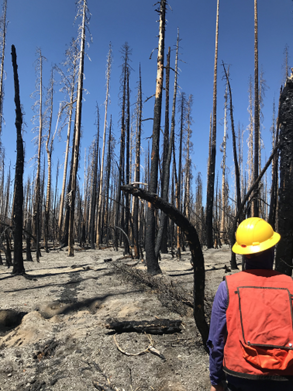
Dixie Fire, Lassen Volcanic National Park, California (2021)
Dixie Fire, Lassen Volcanic National Park, California (2021)USGS crew measuring forest conditions following the Dixie Fire in 2021. Lassen Volcanic National Park. California.
Dixie Fire, Lassen Volcanic National Park, California (2021)
Dixie Fire, Lassen Volcanic National Park, California (2021)USGS crew measuring forest conditions following the Dixie Fire in 2021. Lassen Volcanic National Park. California.
A bucket holds an assortment of forage-sized fishes from Lion Bay on the Beaufort Sea, Alaska. Species include saffron cod (Eleginus gracilis), Arctic cod (Boreogadus saida), fourhorn sculpin (Myoxocephalus quadricornis), and Arctic smelt (Osmerus mordax), among others.
Fourhorn sculpin, Beaufort Sea, Alaska. A fourhorn sculpin sits in a net pen underwater.
An assortment of forage sized fishes from the Beaufort Sea, Alaska lie on a measuring board.
A saffron cod (left, Eleginus gracilis) and Arctic cod (right, Boreogadus saida) sit on a measuring board for comparison.
Eroding and slumping shoreline, Beaufort Sea, Alaska
Eroding and slumping shoreline, Beaufort Sea, AlaskaAn eroding and slumping shoreline adjacent to a fyke net fishing site in Lion Bay, Beaufort Sea, Alaska.
Eroding and slumping shoreline, Beaufort Sea, Alaska
Eroding and slumping shoreline, Beaufort Sea, AlaskaAn eroding and slumping shoreline adjacent to a fyke net fishing site in Lion Bay, Beaufort Sea, Alaska.