Distribution map of sea otters in southcentral Alaska
Distribution map of sea otters in southcentral AlaskaDistribution map of sea otters in southcentral Alaska from aerial surveys flown in 2014, 2017, and 2019.

Official websites use .gov
A .gov website belongs to an official government organization in the United States.
Secure .gov websites use HTTPS
A lock () or https:// means you’ve safely connected to the .gov website. Share sensitive information only on official, secure websites.
Browse images from a wide range of science topics covered by USGS. All items in this gallery are considered public domain unless otherwise noted.
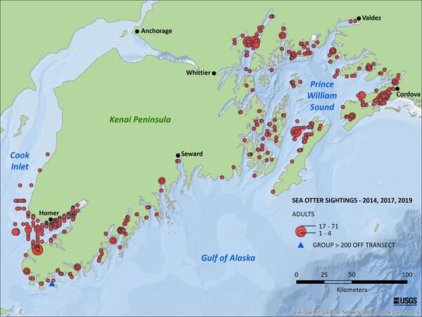
Distribution map of sea otters in southcentral Alaska from aerial surveys flown in 2014, 2017, and 2019.
Distribution map of sea otters in southcentral Alaska from aerial surveys flown in 2014, 2017, and 2019.

USGS Alaska Science Center scientists, Danielle Gerik, Bronwen Wang, and Anchorage School District student volunteer, Gabe Gray count and identify birds for the 2021 Anchorage Christmas Bird Count at Prospect Heights, Anchorage, Alaska.
USGS Alaska Science Center scientists, Danielle Gerik, Bronwen Wang, and Anchorage School District student volunteer, Gabe Gray count and identify birds for the 2021 Anchorage Christmas Bird Count at Prospect Heights, Anchorage, Alaska.

USGS Alaska Science Center scientists, Danielle Gerik, Bronwen Wang, and Anchorage School District student volunteer, Gabe Gray count and identify birds for the 2021 Anchorage Christmas Bird Count at Prospect Heights, Anchorage, Alaska.
USGS Alaska Science Center scientists, Danielle Gerik, Bronwen Wang, and Anchorage School District student volunteer, Gabe Gray count and identify birds for the 2021 Anchorage Christmas Bird Count at Prospect Heights, Anchorage, Alaska.

USGS Alaska Science Center scientists, Danielle Gerik, Bronwen Wang, and Anchorage School District student volunteer, Gabe Gray count and identify birds for the 2021 Anchorage Christmas Bird Count at Prospect Heights, Anchorage, Alaska.
USGS Alaska Science Center scientists, Danielle Gerik, Bronwen Wang, and Anchorage School District student volunteer, Gabe Gray count and identify birds for the 2021 Anchorage Christmas Bird Count at Prospect Heights, Anchorage, Alaska.

USGS Alaska Science Center scientists, Danielle Gerik, Bronwen Wang, and Anchorage School District student volunteer, Gabe Gray count and identify birds for the 2021 Anchorage Christmas Bird Count at Prospect Heights, Anchorage, Alaska.
USGS Alaska Science Center scientists, Danielle Gerik, Bronwen Wang, and Anchorage School District student volunteer, Gabe Gray count and identify birds for the 2021 Anchorage Christmas Bird Count at Prospect Heights, Anchorage, Alaska.

Remote weather stations, like this one at Wolverine Glacier, collect data near each glacier so scientists can understand regional climate influence on the glaciers.
Remote weather stations, like this one at Wolverine Glacier, collect data near each glacier so scientists can understand regional climate influence on the glaciers.

A resting sea otter with eyes closed. Photo taken in the Homer harbor in Alaska. Sea otters provide one of the best documented examples of top-down forcing effects on the structure and function of nearshore marine ecosystems in the North Pacific Ocean
A resting sea otter with eyes closed. Photo taken in the Homer harbor in Alaska. Sea otters provide one of the best documented examples of top-down forcing effects on the structure and function of nearshore marine ecosystems in the North Pacific Ocean

A resting sea otter in the Homer harbor, Alaska. Photo was taken in 2011. Sea otters provide one of the best documented examples of top-down forcing effects on the structure and function of nearshore marine ecosystems in the North Pacific Ocean.
A resting sea otter in the Homer harbor, Alaska. Photo was taken in 2011. Sea otters provide one of the best documented examples of top-down forcing effects on the structure and function of nearshore marine ecosystems in the North Pacific Ocean.
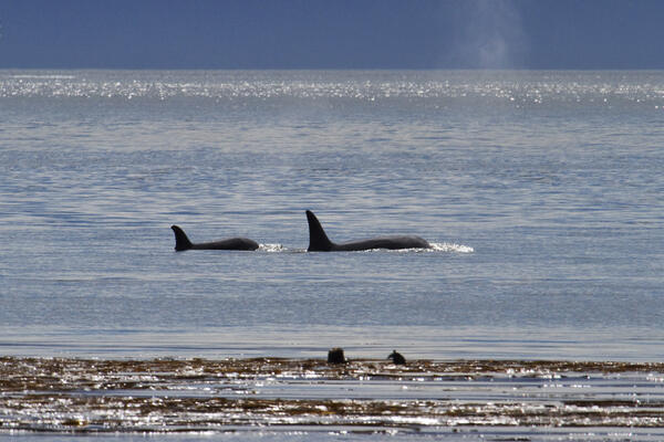
A sea otter resting in kelp as two orcas swim past. Photo taken in Glacier Bay at Point Carolus, Alaska
A sea otter resting in kelp as two orcas swim past. Photo taken in Glacier Bay at Point Carolus, Alaska

This is a graphical abstract for a publication by the USGS that evaluates satellite imagery for monitoring large Pacific walrus haulouts in northwestern Alaska.
This is a graphical abstract for a publication by the USGS that evaluates satellite imagery for monitoring large Pacific walrus haulouts in northwestern Alaska.

Scientist working on Sperry Glacier in Glacier National Park, Montana. Sperry Glacier occupies a broad, shallow cirque situated just beneath and west of the Continental Divide in the Lewis Mountain Range of Glacier National Park, Montana. Due to its position on the Continental Divide the glacier is influenced by both maritime and continental air masses.
Scientist working on Sperry Glacier in Glacier National Park, Montana. Sperry Glacier occupies a broad, shallow cirque situated just beneath and west of the Continental Divide in the Lewis Mountain Range of Glacier National Park, Montana. Due to its position on the Continental Divide the glacier is influenced by both maritime and continental air masses.

Glaucous-winged Gulls fight over a Pacific Herring near Gull Island in Kachemak Bay, Alaska.
Glaucous-winged Gulls fight over a Pacific Herring near Gull Island in Kachemak Bay, Alaska.

Photo of Katakturuk River in Alaska with aufeis. Aufeis forms when overflowing water freezes as it encounters cold air during the winter.
Photo of Katakturuk River in Alaska with aufeis. Aufeis forms when overflowing water freezes as it encounters cold air during the winter.

Lucas Zeller takes notes on firn core density and stratigraphy as part of a larger study on Wolverine Glacier, AK.
Lucas Zeller takes notes on firn core density and stratigraphy as part of a larger study on Wolverine Glacier, AK.

Four Tufted Puffins on the water, near their breeding colony at Gull Island in Kachemak Bay, Alaska
Four Tufted Puffins on the water, near their breeding colony at Gull Island in Kachemak Bay, Alaska

A juvenile Marbled Murrelet near Gull Island in Kachemak Bay, Alaska. The Marbled Murrelet spends most of its life at sea, coming to land only in the summer to nest.
A juvenile Marbled Murrelet near Gull Island in Kachemak Bay, Alaska. The Marbled Murrelet spends most of its life at sea, coming to land only in the summer to nest.

USGS geologist George Case is recording data on graphite mineralization in core sample from the Graphite Creek deposit in Nome, Alaska. The purpose of this research is to determine the genesis and key attributes of the world class large flake Graphite Creek deposit on the western Seward Peninsula, Alaska.
USGS geologist George Case is recording data on graphite mineralization in core sample from the Graphite Creek deposit in Nome, Alaska. The purpose of this research is to determine the genesis and key attributes of the world class large flake Graphite Creek deposit on the western Seward Peninsula, Alaska.
The Graphite Creek Deposit on the Seward Peninsula, Alaska, crops out here at Graphite Creek. Mining in this area previously took place from roughly 1900-1916. Graphite is a critical mineral which the US relies entirely on imports.
The Graphite Creek Deposit on the Seward Peninsula, Alaska, crops out here at Graphite Creek. Mining in this area previously took place from roughly 1900-1916. Graphite is a critical mineral which the US relies entirely on imports.

Alaska Science Center geologist Doug Kreiner and University of Alaska, Fairbanks professor Sean Regan discuss the district-scale geology with the chief exploration geologist at Pogo Mine. This is a new collaborative study with USGS, UAF and Pogo Mine, to collaborate on unraveling the genesis of Pogo, an important producer of gold in Alaska with critical mi
Alaska Science Center geologist Doug Kreiner and University of Alaska, Fairbanks professor Sean Regan discuss the district-scale geology with the chief exploration geologist at Pogo Mine. This is a new collaborative study with USGS, UAF and Pogo Mine, to collaborate on unraveling the genesis of Pogo, an important producer of gold in Alaska with critical mi

USGS Geologist Susan Karl investigates an outcrop of massive flake graphite (dark gray rock) at the Graphite Creek deposit located on the Seward Peninsula, Alaska. An adit, a horizontal passage leading into a mine for the purposes of access or drainage, from historical mining is visible in the corner.
USGS Geologist Susan Karl investigates an outcrop of massive flake graphite (dark gray rock) at the Graphite Creek deposit located on the Seward Peninsula, Alaska. An adit, a horizontal passage leading into a mine for the purposes of access or drainage, from historical mining is visible in the corner.

Geologist, Sue Karl, at Graphite Creek Deposit on the Seward Peninsula, Alaska. She is making field observations and measurements about the flake graphite deposit and the surrounding host rocks. These observations were used in developing a model of flake graphite genesis. Graphite is a critical mineral which the US depends entirely on imports.
Geologist, Sue Karl, at Graphite Creek Deposit on the Seward Peninsula, Alaska. She is making field observations and measurements about the flake graphite deposit and the surrounding host rocks. These observations were used in developing a model of flake graphite genesis. Graphite is a critical mineral which the US depends entirely on imports.