
Lake trout (Salvelinus namaycush). Lake trout captured in Lake Clark National Park as part of a study to examine mercury biomagnification in lake food webs. Photo courtesy of U.S. National Park Service, Public Domain
Images
Browse images from a wide range of science topics covered by USGS. All items in this gallery are considered public domain unless otherwise noted.
Filter Total Items: 1612

Scientist holding lake trout
Lake trout (Salvelinus namaycush). Lake trout captured in Lake Clark National Park as part of a study to examine mercury biomagnification in lake food webs. Photo courtesy of U.S. National Park Service, Public Domain

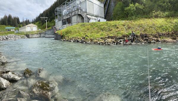
Streamflow discharge measurement at Solomon Gulch Tailrace, Valdez, Alaska
Streamflow discharge measurement at Solomon Gulch Tailrace, Valdez, AlaskaUSGS staff measuring streamflow at the Solomon Gulch Tailrace with a tethered Acoustic Doppler Current Profiler. This is one of 12 streamgages that the USGS Alaska Science Center operates in cooperation with hydropower providers across Alaska. Data are used for operation, regulation, and planning purposes.
Solomon Gulch
USGS staff measuring discharge at the Solomon Gulch Hydropower tailrace, Valdez Alaska.
USGS staff measuring discharge at the Solomon Gulch Hydropower tailrace, Valdez Alaska.

Searching for landbird nests in Denali National Park and Preserve
Searching for landbird nests in Denali National Park and PreserveUSGS biologists Steve Matsuoka, Lauren Hitt, and Rachel Richardson search for landbird nests in Denali National Park and Preserve.
Searching for landbird nests in Denali National Park and Preserve
Searching for landbird nests in Denali National Park and PreserveUSGS biologists Steve Matsuoka, Lauren Hitt, and Rachel Richardson search for landbird nests in Denali National Park and Preserve.

Female sea otter, Cook Inlet, Alaska
A female sea otter resting in the morning light in Cook Inlet Alaska.
A female sea otter resting in the morning light in Cook Inlet Alaska.
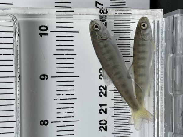
Two juvenile coho salmon used in a heat stress experiment
Two juvenile coho salmon used in a heat stress experimentTwo juvenile coho salmon (Oncorhynchus kisutch) used in a heat stress experiment. Alaska Department of Fish and Game’s William Jack Hernandez Sport Fish Hatchery, Anchorage, Alaska, USA.

Scientist with data notebook
Scientist uses radio-echo-sounding to study firn compaction on Wolverine Glacier, Alaska. Radio-echo sounding (RES) is a technique used by glaciologists to measure the internal structure, ice thickness and sub-ice morphology of glaciers. This tool is equivalent to X-rays for the medical profession and the physicists.
Scientist uses radio-echo-sounding to study firn compaction on Wolverine Glacier, Alaska. Radio-echo sounding (RES) is a technique used by glaciologists to measure the internal structure, ice thickness and sub-ice morphology of glaciers. This tool is equivalent to X-rays for the medical profession and the physicists.

A researcher gazes across Wolverine Glacier and the surrounding snow-covered mountains
A researcher gazes across Wolverine Glacier and the surrounding snow-covered mountainsA researcher gazes across Wolverine Glacier and the surrounding snow-covered mountains during an early spring visit to collect mass balance data.

Icy Alsek River in winter
Randy Host preparing to sample discharge and collect water quality samples on an icy Alsek River in winter.
Randy Host preparing to sample discharge and collect water quality samples on an icy Alsek River in winter.

Taku River Layout
Illustration detailing the Taku River layout. Visit USGS Transboundary River Monitoring in Southeast Alaska for more information about our research.
Illustration detailing the Taku River layout. Visit USGS Transboundary River Monitoring in Southeast Alaska for more information about our research.

Unuk River Layout
Illustration detailing the Unuk River layout. Visit USGS Transboundary River Monitoring in Southeast Alaska for more information about our research.
Illustration detailing the Unuk River layout. Visit USGS Transboundary River Monitoring in Southeast Alaska for more information about our research.

Salmon River Layout
Illustration detailing the Salmon River layout. Visit USGS Transboundary River Monitoring in Southeast Alaska for more information about our research.
Illustration detailing the Salmon River layout. Visit USGS Transboundary River Monitoring in Southeast Alaska for more information about our research.

Alsek River Layout
Illustration detailing the Alsek River layout. Visit USGS Transboundary River Monitoring in Southeast Alaska for more information about our research.
Illustration detailing the Alsek River layout. Visit USGS Transboundary River Monitoring in Southeast Alaska for more information about our research.

USGS Alaska Transboundary Rivers DEM
USGS Alaska Transboundary Rivers DEM. Visit USGS Transboundary River Monitoring in Southeast Alaska for more information about our research.
USGS Alaska Transboundary Rivers DEM. Visit USGS Transboundary River Monitoring in Southeast Alaska for more information about our research.

Stikine River Layout
Illustration detailing the Stikine River layout. Visit USGS Transboundary River Monitoring in Southeast Alaska for more information about our research.
Illustration detailing the Stikine River layout. Visit USGS Transboundary River Monitoring in Southeast Alaska for more information about our research.

White-fronted goose flies over a nesting area near Point Lonely, AK
White-fronted goose flies over a nesting area near Point Lonely, AKA white-fronted goose flies over a nesting area near Point Lonely, Alaska. For more information about this USGS study read "Effects of industrial and investigator disturbance on Arctic-nesting geese" at: https://pubs.er.usgs.gov/publication/70192845

Weighing type precipitation gage and new radar-based sensor
Weighing type precipitation gage and new radar-based sensorThe Wolverine Glacier weather station was installed in 1968, and at 3250 ft is the highest elevation long-term weather record on the Kenai Peninsula. On October 19, 2020, USGS scientists upgraded the power system to a Lithium battery bank and installed a radar-based precipitation sensor (Lufft WS-100) to compare with the weighing based precipitation gage.

Black Oystercatcher on Gull Island, Alaska
Black Oystercatcher on Gull Island, Kachemak Bay, Alaska
Black Oystercatcher on Gull Island, Kachemak Bay, Alaska

Aerial view of Wolverine Glacier icefall
An aerial view of the upper cracks in the Wolverine Glacier icefall as sunset approaches.
An aerial view of the upper cracks in the Wolverine Glacier icefall as sunset approaches.

Wolverine Glacier weather station on the Kenai Peninsula, Alaska
Wolverine Glacier weather station on the Kenai Peninsula, AlaskaThe Wolverine Glacier weather station was installed in 1968, and at 3250 ft is the highest elevation long-term weather record on the Kenai Peninsula.
Wolverine Glacier weather station on the Kenai Peninsula, Alaska
Wolverine Glacier weather station on the Kenai Peninsula, AlaskaThe Wolverine Glacier weather station was installed in 1968, and at 3250 ft is the highest elevation long-term weather record on the Kenai Peninsula.

Close up of the new radar precipitation sensor on the top of the pole
Close up of the new radar precipitation sensor on the top of the poleThe Wolverine Glacier weather station was installed in 1968, and at 3250 ft is the highest elevation long-term weather record on the Kenai Peninsula. Close up of the new radar precipitation sensor on the top of the pole. The crazy looking thing in the middle of the picture is an aspirated temperature sensor.