
Katmai National Park and Preserve supports a large population of Bald Eagle (Haliaeetus leucocephalus). In summer, eagles are commonly observed scavenging on fish carcasses along beaches and streams.
Images
Browse images from a wide range of science topics covered by USGS. All items in this gallery are considered public domain unless otherwise noted.
Filter Total Items: 1612
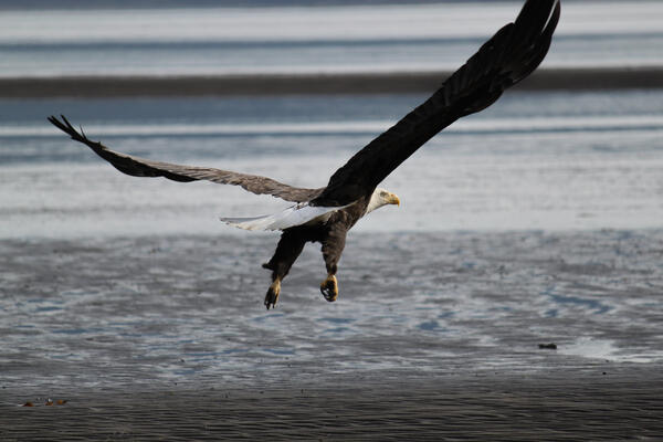
Easy Opportunity for Bald Eagles
Katmai National Park and Preserve supports a large population of Bald Eagle (Haliaeetus leucocephalus). In summer, eagles are commonly observed scavenging on fish carcasses along beaches and streams.
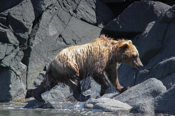
Drip Dry for Katmai Brown Bears
Katmai National Park and Preserve is home to over 2,200 brown bears (Ursus arctos). Bears that live along the Katmai coast are known to swim several miles across the ocean in search of marine mammal carcasses, marine invertebrates, and beach grasses.
Katmai National Park and Preserve is home to over 2,200 brown bears (Ursus arctos). Bears that live along the Katmai coast are known to swim several miles across the ocean in search of marine mammal carcasses, marine invertebrates, and beach grasses.

A "Wreck" of Seabirds
A Black-footed Albatross (Phoebastria nigripes) carcass lies on the beach of Hallo Bay. Since the massive die-off of Common Murres in the Gulf of Alaska during 2015-2016, coastal communities across Alaska have annually reported dead and dying seabirds on their beaches.
A Black-footed Albatross (Phoebastria nigripes) carcass lies on the beach of Hallo Bay. Since the massive die-off of Common Murres in the Gulf of Alaska during 2015-2016, coastal communities across Alaska have annually reported dead and dying seabirds on their beaches.

Beach Walks on Nukshak Island
A crew of scientists walk the rocky beaches of Nukshak Island in Katmai National Park and Preserve looking for sea otter carcasses and skulls.
A crew of scientists walk the rocky beaches of Nukshak Island in Katmai National Park and Preserve looking for sea otter carcasses and skulls.

Community Flyer for USGS Walrus Carcass Surveys
This is a community flyer for distribution in Point Lay, Alaska, to alert community members of USGS activities in the area. A collaborative team of USGS, the North Slope Borough, University of Alaska Fairbanks, and Point Lay residents will assist in surveys of walrus carcasses at a remote coastal haulout that has been used by hundreds of thousands of walruses e
This is a community flyer for distribution in Point Lay, Alaska, to alert community members of USGS activities in the area. A collaborative team of USGS, the North Slope Borough, University of Alaska Fairbanks, and Point Lay residents will assist in surveys of walrus carcasses at a remote coastal haulout that has been used by hundreds of thousands of walruses e

A Salad for Katmai's Brown Bears
Katmai National Park and Preserve is home to over 2,200 brown bears (Ursus arctos). Brown bears are omnivores that frequently "graze" in meadows along the Katmai coast until the salmon runs start in late July.
Katmai National Park and Preserve is home to over 2,200 brown bears (Ursus arctos). Brown bears are omnivores that frequently "graze" in meadows along the Katmai coast until the salmon runs start in late July.

Hide-and-Seek with Black Oystercatchers
A Black Oystercatcher (Haematopus bachmani) chick hides in a rock crevice on one of the Shakun Islets of Katmai National Park and Preserve. Unlike their name suggests, Black Oystercatchers rarely consume oysters, but rather intertidal marine invertebrates such as limpets, whelks and chitons, as well as crabs, sea urchins, barnacles, and isopods.
A Black Oystercatcher (Haematopus bachmani) chick hides in a rock crevice on one of the Shakun Islets of Katmai National Park and Preserve. Unlike their name suggests, Black Oystercatchers rarely consume oysters, but rather intertidal marine invertebrates such as limpets, whelks and chitons, as well as crabs, sea urchins, barnacles, and isopods.
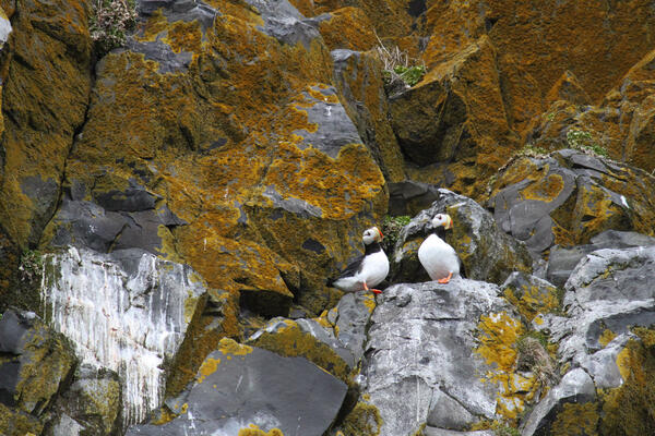
Horned Puffins of the St. Matthew Grotto
Pair of Horned Puffins (Fratercula corniculata) rest along the lichen-covered sea cliffs of a grotto on St. Matthew Island, Alaska. The island is home to over 1.6 million nesting seabirds, including murres, kittiwakes, puffins and auklets.
Pair of Horned Puffins (Fratercula corniculata) rest along the lichen-covered sea cliffs of a grotto on St. Matthew Island, Alaska. The island is home to over 1.6 million nesting seabirds, including murres, kittiwakes, puffins and auklets.
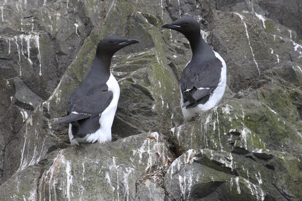
Thick-billed Murre of the St. Matthew Grotto
Pair of Thick-billed Murres (Uria lomvia) nest along the sea cliffs of a grotto on St. Matthew Island, Alaska. The island is home to over 1.6 million nesting seabirds, including cormorants, kittiwakes, puffins and auklets.
Pair of Thick-billed Murres (Uria lomvia) nest along the sea cliffs of a grotto on St. Matthew Island, Alaska. The island is home to over 1.6 million nesting seabirds, including cormorants, kittiwakes, puffins and auklets.

Southern View from the foothills of Glory of Russia Cape
Southern View from the foothills of Glory of Russia CapeGlory of Russia Cape, named by Russian Polar explorer, Gavril Sarychev, is the northernmost point of St. Matthew Island. The cape is best know for the 1989 shipwreck of the Greek ship "Milos Reefer". The rusted and battered haul is still visible below the rocky cliffs.

Pelagic Cormorants of the St. Matthew Grotto
Pair of Pelagic Cormorant (Urile pelagicus) nest along the sea cliffs of a grotto on St. Matthew Island. The island is home to over 1.6 million nesting seabirds, including murres, kittiwakes, puffins and auklets.
Pair of Pelagic Cormorant (Urile pelagicus) nest along the sea cliffs of a grotto on St. Matthew Island. The island is home to over 1.6 million nesting seabirds, including murres, kittiwakes, puffins and auklets.
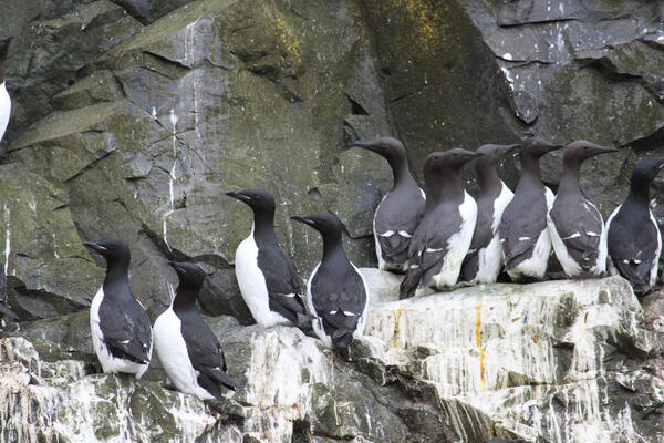
Murres of the St. Matthew Grotto
Pairs of Common Murre (Uria aalge; chocolate-colored hue) and Thick-billed Murre (Uria lomvia; black-colored hue) nest along the sea cliffs of a grotto on St. Matthew Island. The island is home to over 1.6 million nesting seabirds, including cormorants, kittiwakes, puffins and auklets.
Pairs of Common Murre (Uria aalge; chocolate-colored hue) and Thick-billed Murre (Uria lomvia; black-colored hue) nest along the sea cliffs of a grotto on St. Matthew Island. The island is home to over 1.6 million nesting seabirds, including cormorants, kittiwakes, puffins and auklets.
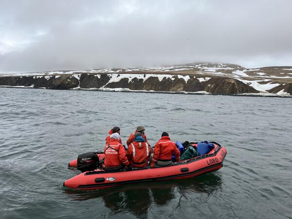
The Morning Commute
R/V Tiglax deckhand, Patrick, transports scientists from the ship to Hall Island, in order to conduct distance-sampling surveys for Rock Sandpiper and McKay's Bunting.
R/V Tiglax deckhand, Patrick, transports scientists from the ship to Hall Island, in order to conduct distance-sampling surveys for Rock Sandpiper and McKay's Bunting.
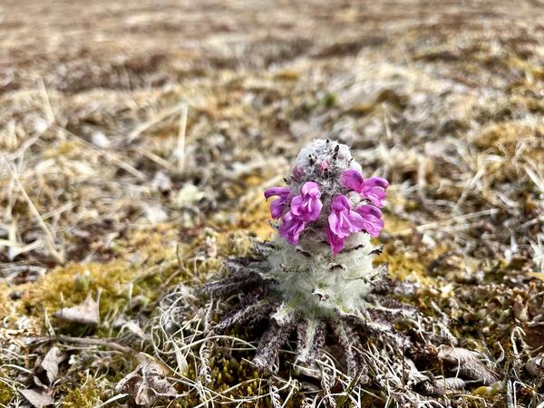
Blooming woolly lousewort
Woolly lousewort (Pedicularis lanata), also known as "bumble-bee flower" are native to the alpine regions of Alaska, Canada, and Greenland. This compact and hardy plant can withstand even the strongest Bering Sea winds. The "wool", as it is known, is a layer of fuzzy insulation, which wraps around the steam of the plant, protecting it from wind and cold.
Woolly lousewort (Pedicularis lanata), also known as "bumble-bee flower" are native to the alpine regions of Alaska, Canada, and Greenland. This compact and hardy plant can withstand even the strongest Bering Sea winds. The "wool", as it is known, is a layer of fuzzy insulation, which wraps around the steam of the plant, protecting it from wind and cold.
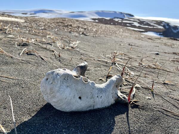
Jaw of a walrus
The lower jawbone of an adult male walrus rests on the sandy shore of St. Matthew Island, Alaska. The Pacific Walrus (Odobenus rosmarus) is a large pinniped that occurs within the Bering and Chukchi Sea regions. Although more commonly observed on the mainland coast of western Alaska, walrus "haulouts" have been observed on St.
The lower jawbone of an adult male walrus rests on the sandy shore of St. Matthew Island, Alaska. The Pacific Walrus (Odobenus rosmarus) is a large pinniped that occurs within the Bering and Chukchi Sea regions. Although more commonly observed on the mainland coast of western Alaska, walrus "haulouts" have been observed on St.
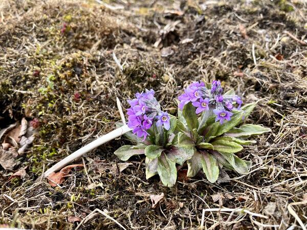
Blooming Arctic primrose (Primula pumila)
Arctic primrose are native to the alpine regions of Alaska, Yukon, Northwest Territories and Far Eastern Russia. On St. Matthew Island, these flowers are typically observed on moist alpine slopes where snow remains long into the summer months. The flower was observed while conducting McKay's Bunting and Rock Sandpiper distance-sampling surveys on St.
Arctic primrose are native to the alpine regions of Alaska, Yukon, Northwest Territories and Far Eastern Russia. On St. Matthew Island, these flowers are typically observed on moist alpine slopes where snow remains long into the summer months. The flower was observed while conducting McKay's Bunting and Rock Sandpiper distance-sampling surveys on St.

Male McKay's Bunting Foraging on Snow
The McKay's Bunting (Plectrophenax hyperboreus) is endemic to the Bering Sea Region and only breeds on St. Matthew and Hall islands. Designated as a species of high conservation concern due to its small population size, surveys show that the species has continued to decline since the initial survey effort in 2003.
The McKay's Bunting (Plectrophenax hyperboreus) is endemic to the Bering Sea Region and only breeds on St. Matthew and Hall islands. Designated as a species of high conservation concern due to its small population size, surveys show that the species has continued to decline since the initial survey effort in 2003.
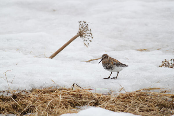
Female Pribilof Rock Sandpiper Foraging on Snow
The Pribilof Rock Sandpiper (Calidris ptilocnemis ptilocnemis) is endemic to the Bering Sea Region and only breeds on the islands of St. Matthew, Hall, St. Paul, and St. George. The Rock Sandpiper is one of two focal species monitored as part of a long-term population study led by USGS Alaska Science Center, U.S.
The Pribilof Rock Sandpiper (Calidris ptilocnemis ptilocnemis) is endemic to the Bering Sea Region and only breeds on the islands of St. Matthew, Hall, St. Paul, and St. George. The Rock Sandpiper is one of two focal species monitored as part of a long-term population study led by USGS Alaska Science Center, U.S.
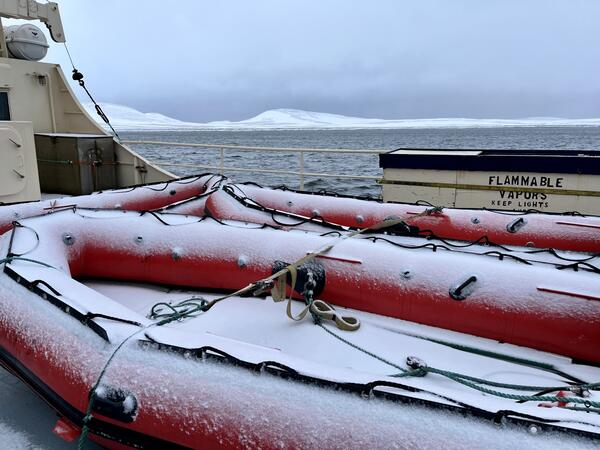
Is it Summer Yet?
A pair of skiffs sit atop the R/V Tiglax on a cold summer morning in the Bering Sea. It is not uncommon for snow showers any time of the year in the Bering Sea region, however, this particular visit to St. Matthew proved to be extra chilly, as it never reaches over 40 degrees Fahrenheit into mid-June.
A pair of skiffs sit atop the R/V Tiglax on a cold summer morning in the Bering Sea. It is not uncommon for snow showers any time of the year in the Bering Sea region, however, this particular visit to St. Matthew proved to be extra chilly, as it never reaches over 40 degrees Fahrenheit into mid-June.
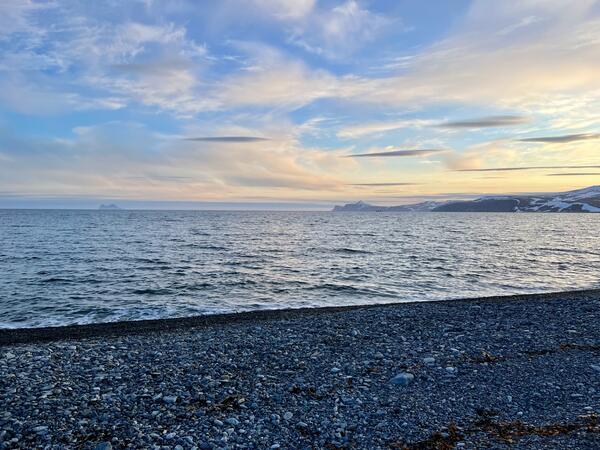
Summer sunset on St. Matthew Island
During the summer months on St. Matthew Island the sun never truly sets. The amber hues on the horizon serve as the perfect backdrop to a long, yet successful, day conducting Rock Sandpiper and McKay's Bunting distance-sampling surveys. The sunset photo was taken at 12:10am.
During the summer months on St. Matthew Island the sun never truly sets. The amber hues on the horizon serve as the perfect backdrop to a long, yet successful, day conducting Rock Sandpiper and McKay's Bunting distance-sampling surveys. The sunset photo was taken at 12:10am.
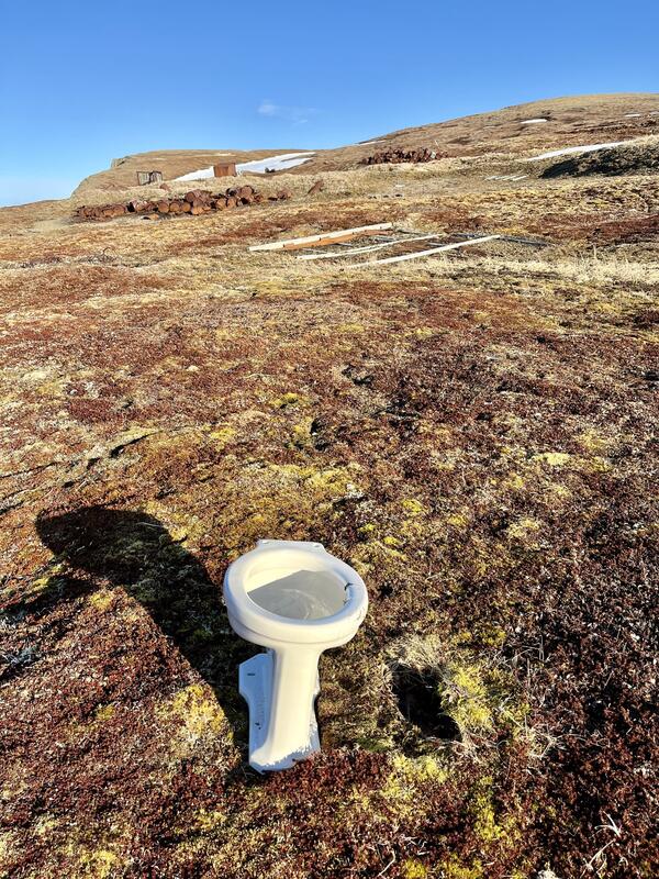
What Remains of the St. Matthew LORAN Station
The St. Matthew Island LORAN station began operation by the Coast Guard on July 10, 1944. The station closed on September 13, 1946. Although equipment was removed from the island a few years after the station was closed, large and heavy objects were left behind, including this toilet, which stands in nearly pristine condition.
The St. Matthew Island LORAN station began operation by the Coast Guard on July 10, 1944. The station closed on September 13, 1946. Although equipment was removed from the island a few years after the station was closed, large and heavy objects were left behind, including this toilet, which stands in nearly pristine condition.