
King Eiders are well adapted to the frigid climate of the Arctic. These birds feed on mollusks and can reach depths up to 150 meters when diving in the ocean.
Images
Browse images from a wide range of science topics covered by USGS. All items in this gallery are considered public domain unless otherwise noted.
Filter Total Items: 1612
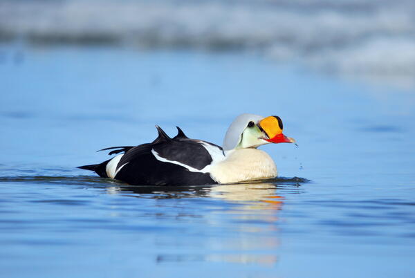
Male King Eider
King Eiders are well adapted to the frigid climate of the Arctic. These birds feed on mollusks and can reach depths up to 150 meters when diving in the ocean.

Female Bar-tailed Godwit at a breeding site along the Colville River, Alaska
Female Bar-tailed Godwit at a breeding site along the Colville River, AlaskaFemale Bar-tailed Godwit at a breeding site along the Colville River, Alaska.
Female Bar-tailed Godwit at a breeding site along the Colville River, Alaska
Female Bar-tailed Godwit at a breeding site along the Colville River, AlaskaFemale Bar-tailed Godwit at a breeding site along the Colville River, Alaska.

Scientist holding Whimbrel with a solar-powered satellite transmitter
Scientist holding Whimbrel with a solar-powered satellite transmitterBob Gill, Jr., is holding a Whimbrel equipped with a solar-powered satellite transmitter. The photo was taken along the Colville River near Nuiqsut, Alaska.
Scientist holding Whimbrel with a solar-powered satellite transmitter
Scientist holding Whimbrel with a solar-powered satellite transmitterBob Gill, Jr., is holding a Whimbrel equipped with a solar-powered satellite transmitter. The photo was taken along the Colville River near Nuiqsut, Alaska.

Instrumentation Array, Beaver Creek Near Michael Lake, Alaska
Instrumentation Array, Beaver Creek Near Michael Lake, AlaskaInstrumentation array with a YSI multiparameter sonde, a dissolved CO2 sensor, and a CDOM sensor.
Instrumentation Array, Beaver Creek Near Michael Lake, Alaska
Instrumentation Array, Beaver Creek Near Michael Lake, AlaskaInstrumentation array with a YSI multiparameter sonde, a dissolved CO2 sensor, and a CDOM sensor.

Instrumentation Array, Beaver Creek Above Victoria Creek, Alaska
Instrumentation Array, Beaver Creek Above Victoria Creek, AlaskaInstrumentation array with a YSI multiparameter sonde, a dissolved CO2 sensor, and a CDOM sensor.
Instrumentation Array, Beaver Creek Above Victoria Creek, Alaska
Instrumentation Array, Beaver Creek Above Victoria Creek, AlaskaInstrumentation array with a YSI multiparameter sonde, a dissolved CO2 sensor, and a CDOM sensor.

Andy Reeves Staff Photo
Andy Reeves is holding a Glaucous Gull that was capture, sampled for avian influenza and banded near Barrow, Alaska.
Andy Reeves is holding a Glaucous Gull that was capture, sampled for avian influenza and banded near Barrow, Alaska.

Setting up GPS system before mapping Nome Creek Experimental Watershed
Setting up GPS system before mapping Nome Creek Experimental WatershedJosh Koch and Steve Jepsen set up a GPS system before starting a day of mapping in the Nome Creek Experimental Watershed. https://www.usgs.gov/centers/asc/science/nome-creek-experimental-watershed?qt-science_

Walrus In The Water Up Close
Walruses in the Chukchi Sea during a tagging survey onboard the Norseman II in June 2010.
Walruses in the Chukchi Sea during a tagging survey onboard the Norseman II in June 2010.

Walrus Female And Calf Up Close From The Side
Walruses in the Chukchi Sea during a tagging survey onboard the Norseman II in June 2010.
Walruses in the Chukchi Sea during a tagging survey onboard the Norseman II in June 2010.

Walrus Female And Calf On An Ice Floe
Walruses in the Chukchi Sea during a tagging survey onboard the Norseman II in June 2010.
Walruses in the Chukchi Sea during a tagging survey onboard the Norseman II in June 2010.

Single Walrus From The Side View
Walruses in the Chukchi Sea during a tagging survey onboard the Norseman II in June 2010.
Walruses in the Chukchi Sea during a tagging survey onboard the Norseman II in June 2010.

Walrus Female And Calf On An Ice Floe, Next To Another Walrus
Walrus Female And Calf On An Ice Floe, Next To Another WalrusWalruses in the Chukchi Sea during a tagging survey onboard the Norseman II in June 2010.
Walrus Female And Calf On An Ice Floe, Next To Another Walrus
Walrus Female And Calf On An Ice Floe, Next To Another WalrusWalruses in the Chukchi Sea during a tagging survey onboard the Norseman II in June 2010.

A sea otter eating a basket star
A sea otter at sunset eating a basket star in Glacier Bay near Bartlett Cove, Alaska
A sea otter at sunset eating a basket star in Glacier Bay near Bartlett Cove, Alaska

The old Kennecott copper mill from the north side
The old Kennecott copper mill from the north. Kennecott was once a thriving mine and mill during the early 1900s. The mines are 5 miles up the mountain.
The old Kennecott copper mill from the north. Kennecott was once a thriving mine and mill during the early 1900s. The mines are 5 miles up the mountain.

Scientists collecting data on South Cascade Glacier, Washington State
Scientists collecting data on South Cascade Glacier, Washington StateScientists collecting data on South Cascade Glacier, Washington State. South Cascade Glacier is located in a north-northwest facing valley near the crest of the Cascade Range in northwest Washington state. In 1959 scientists with the USGS began collecting mass balance data on South Cascade Glacier, now one of five "benchmark glaciers" in the US.

Mallard Duck swimming
Mallard Duck swimming

Rufous Hummingbird in Bellingham, Washington
Rufous Hummingbird in Bellingham, Washington. Rufous Hummingbirds are present in southeast and some select southcentral locations in Alaska.
Rufous Hummingbird in Bellingham, Washington. Rufous Hummingbirds are present in southeast and some select southcentral locations in Alaska.

Black-capped Chickadee perched in a bush
Black-capped Chickadee perched in a bush. This species of chickadee is important in Alaska.
Black-capped Chickadee perched in a bush. This species of chickadee is important in Alaska.

Black-capped Chickadee in a bush
Black-capped Chickadee in a bush. This species of chickadee is important in Alaska.
Black-capped Chickadee in a bush. This species of chickadee is important in Alaska.

Close up of Black-capped Chickadee perched in a bush
Close up of Black-capped Chickadee perched in a bushBlack-capped Chickadee perched in a bush. This species of chickadee is important in Alaska.
Close up of Black-capped Chickadee perched in a bush
Close up of Black-capped Chickadee perched in a bushBlack-capped Chickadee perched in a bush. This species of chickadee is important in Alaska.

Spectacled Eiders Wintering in Northern Bering Sea
Spectacled Eiders Wintering in Northern Bering SeaLarge flock of Spectacled Eiders aggregated in a sea ice lead in the northern Bering Sea, south of St. Lawrence Island, Alaska. Aerial photograph from a helicopter deployed from the USCG Cutter Polar Sea.