
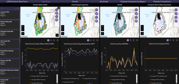
This is a screenshot showing the hydrology for Lake Earl WA inside the CDFW climate hydrology explorer web tool.
Images
California Water Science Center Images
Filter Total Items: 315
CDFW climate hydrology explorer
This is a screenshot showing the hydrology for Lake Earl WA inside the CDFW climate hydrology explorer web tool.
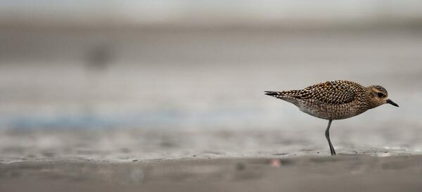
Aerial shot of bird migration
Aerial shot of bird migration. The kōlea, or Pacific Golden-Plover (Pluvialis fulva), is a familiar bird in Hawaiʻi that migrates to Alaska each summer to nest.
Aerial shot of bird migration. The kōlea, or Pacific Golden-Plover (Pluvialis fulva), is a familiar bird in Hawaiʻi that migrates to Alaska each summer to nest.
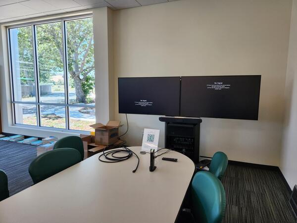
Conference area of Cal Poly San Luis Obispo Field Office
Conference area of Cal Poly San Luis Obispo Field OfficeConference area of Cal Poly San Luis Obispo Field Office. The Tech Park II office space offers various amenities including conference rooms, break areas, and convenient access to campus resources, fostering an environment conducive to collaboration with the university.
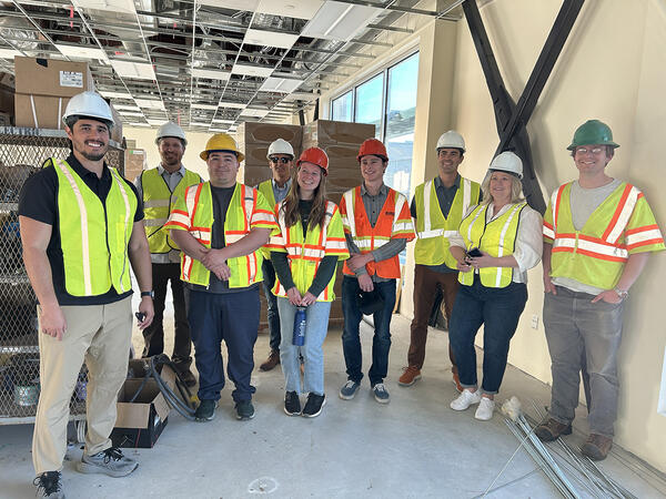
SLOFO Crew
Pictured is the SLOFO team along with others from CAWSC. From left to right: Ed Reeves, Ben Glass, Gustavo Ruiz, Mark Dickman, Colleen Ritter, Daniel Monsalve, Geoff Cromwell, Jeanette Rainey, and James Solum.
Pictured is the SLOFO team along with others from CAWSC. From left to right: Ed Reeves, Ben Glass, Gustavo Ruiz, Mark Dickman, Colleen Ritter, Daniel Monsalve, Geoff Cromwell, Jeanette Rainey, and James Solum.
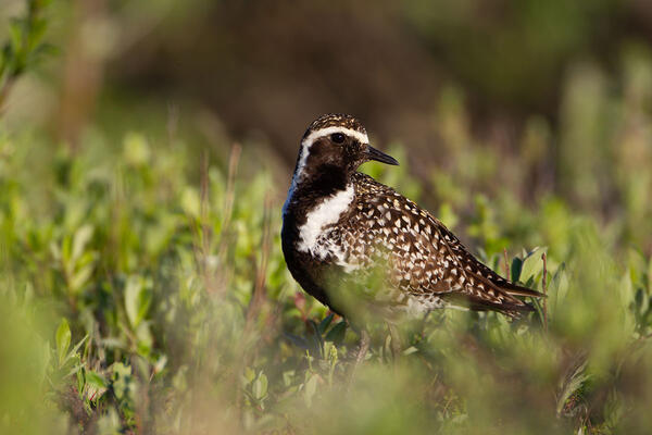
Pacific Golden-Plover (Pluvialis fulva)
The kōlea, or Pacific Golden-Plover (Pluvialis fulva), is a familiar bird in Hawaiʻi that migrates to Alaska each summer to nest.
The kōlea, or Pacific Golden-Plover (Pluvialis fulva), is a familiar bird in Hawaiʻi that migrates to Alaska each summer to nest.
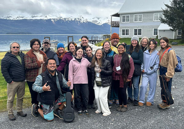
group_resized.jpg
Native Hawaiian and Alaska Native participants and project partners gathered at the Knowledge Exchange in Cordova, Alaska.
Native Hawaiian and Alaska Native participants and project partners gathered at the Knowledge Exchange in Cordova, Alaska.
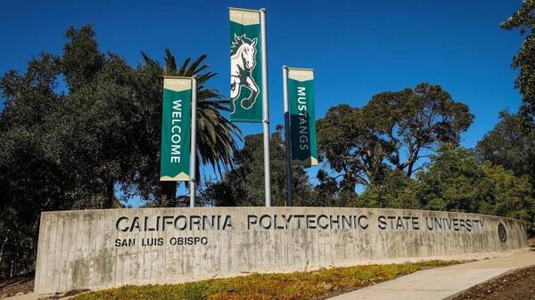
Entrance to the Cal Poly San Luis Obispo campus
Entrance to the Cal Poly San Luis Obispo campus. In late May 2025, the Santa Maria Field Office officially relocated to San Luis Obispo, becoming the SLOFO. The office is now located in the newly built Tech Park II office building on the Cal Poly campus.
Entrance to the Cal Poly San Luis Obispo campus. In late May 2025, the Santa Maria Field Office officially relocated to San Luis Obispo, becoming the SLOFO. The office is now located in the newly built Tech Park II office building on the Cal Poly campus.
Pacific Golden-Plover
The kōlea, or Pacific Golden-Plover (Pluvialis fulva), is a familiar bird in Hawaiʻi that migrates to Alaska each summer to nest.
The kōlea, or Pacific Golden-Plover (Pluvialis fulva), is a familiar bird in Hawaiʻi that migrates to Alaska each summer to nest.
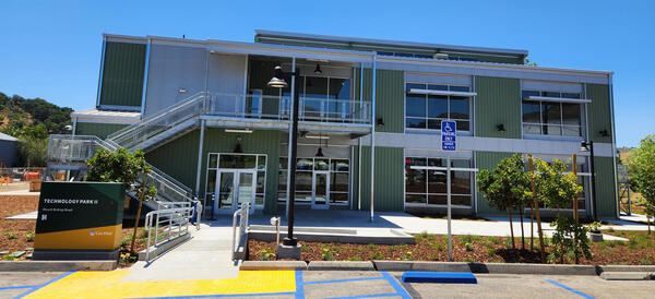
Exterior of Cal Poly Technology Park II office
Exterior of Cal Poly Technology Park II office. The office is now located in the newly built Tech Park II office building on the Cal Poly campus.
Exterior of Cal Poly Technology Park II office. The office is now located in the newly built Tech Park II office building on the Cal Poly campus.

Artichoke field in the Salinas River Valley
Artichoke field in the Salinas River Valley. California’s Salinas Valley is one of the most productive agricultural basins in the world due to the fertile valley soil, temperate climate, and availability of water for irrigation.
Artichoke field in the Salinas River Valley. California’s Salinas Valley is one of the most productive agricultural basins in the world due to the fertile valley soil, temperate climate, and availability of water for irrigation.

Lettuce field in the Salinas River Valley
Lettuce field in the Salinas River Valley. California’s Salinas Valley is one of the most productive agricultural basins in the world due to the fertile valley soil, temperate climate, and availability of water for irrigation.
Lettuce field in the Salinas River Valley. California’s Salinas Valley is one of the most productive agricultural basins in the world due to the fertile valley soil, temperate climate, and availability of water for irrigation.

CAWSC Biogeochemistry group at 2025 IEP Workshop
CAWSC Biogeochemistry group at 2025 IEP Workshop. Left to Right: Back Row - Maura Uebner, Keith Bouma-Gregson, Kyle Leathers; Middle Row - Crystal Sturgeon, Zoё Siman-Tov, Lane Bratz, Emily Richardson, Tamara Kraus, Alex Ryan; Front Row - Nick Framsted
CAWSC Biogeochemistry group at 2025 IEP Workshop. Left to Right: Back Row - Maura Uebner, Keith Bouma-Gregson, Kyle Leathers; Middle Row - Crystal Sturgeon, Zoё Siman-Tov, Lane Bratz, Emily Richardson, Tamara Kraus, Alex Ryan; Front Row - Nick Framsted

Santa Ana Sucker research team
The photo shows members of the research team. From left to right: Tevin Bui (RCD), Jordan Buxton (USGS), Brett Mills (RCD), Alicia Ruan (RCD), and Brock Huntsman (USGS). Inset at right are Marissa Wulff (top) and Jeff Gronemyer (bottom), both of the USGS.
The photo shows members of the research team. From left to right: Tevin Bui (RCD), Jordan Buxton (USGS), Brett Mills (RCD), Alicia Ruan (RCD), and Brock Huntsman (USGS). Inset at right are Marissa Wulff (top) and Jeff Gronemyer (bottom), both of the USGS.
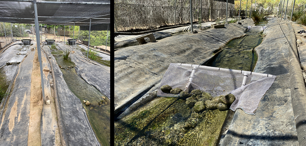
Raceways at the RCD facility
The above photos show raceways at the Riverside Corona Resource Conservation District (RCD) facility.
The above photos show raceways at the Riverside Corona Resource Conservation District (RCD) facility.

Santa Ana Sucker Lure
Example of Santa Ana Sucker (Pantosteus santaanae) lure with a PIT tag attached.
Example of Santa Ana Sucker (Pantosteus santaanae) lure with a PIT tag attached.
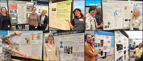
Poster Presenters at 2025 IEP Workshop
CAWSC poster presenters at 2025 IEP Workshop. Clockwise from upper left: Anna Conlen, Elise Shea, Lex Thomas, Zoё Siman-Tov, Bryan Gopez, Emma Walker, David Hart, Maura Uebner, Lawrence Fujiwara, Trevor Violette.
CAWSC poster presenters at 2025 IEP Workshop. Clockwise from upper left: Anna Conlen, Elise Shea, Lex Thomas, Zoё Siman-Tov, Bryan Gopez, Emma Walker, David Hart, Maura Uebner, Lawrence Fujiwara, Trevor Violette.

Santa Ana Sucker (Pantosteus santaanae)
Santa Ana Sucker (Pantosteus santaanae) being measured in PIT tag study done in the late summer and early fall of 2024.
Santa Ana Sucker (Pantosteus santaanae) being measured in PIT tag study done in the late summer and early fall of 2024.
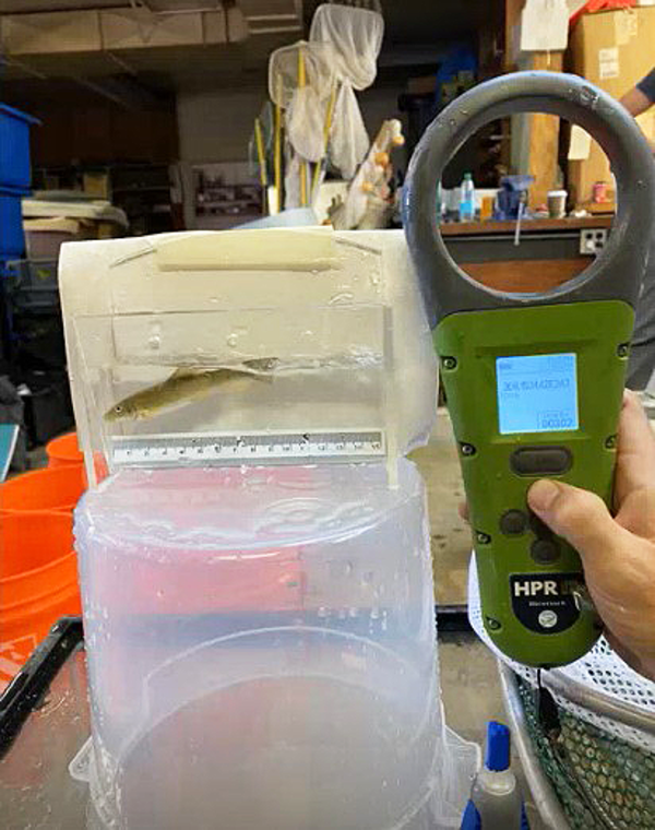
PIT tag reader being tested
This photo shows a passive integrated transponder (PIT) tag reader being used to test a tagged Santa Ana Sucker.
This photo shows a passive integrated transponder (PIT) tag reader being used to test a tagged Santa Ana Sucker.
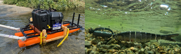
Raft with PIT tag reader and two cameras and PIT tag attached to a lure
Raft with PIT tag reader and two cameras and PIT tag attached to a lureThe photo shows (left) the raft outfitted with the PIT tag reader and two cameras, both facing down into the river. And (right) a PIT tag attached to a lure.

Active (or moving) camera footage of Santa Ana Sucker
Active (or moving) camera footage of Santa Ana SuckerActive (or moving) camera footage of Santa Ana Sucker (Pantosteus santaanae). Cameras were attached to “selfie sticks” and walked up and down the raceways (or fabricated streams).
Active (or moving) camera footage of Santa Ana Sucker
Active (or moving) camera footage of Santa Ana SuckerActive (or moving) camera footage of Santa Ana Sucker (Pantosteus santaanae). Cameras were attached to “selfie sticks” and walked up and down the raceways (or fabricated streams).

Passive Camera Footage of Santa Ana Sucker
Footage of Santa Ana Sucker (Pantosteus santaanae) from passive (or stationary) camera. Part of a USGS study on the effectiveness and safety of the PIT tagging sampling method.
Footage of Santa Ana Sucker (Pantosteus santaanae) from passive (or stationary) camera. Part of a USGS study on the effectiveness and safety of the PIT tagging sampling method.