
Shown clockwise from top left are: 1] setting up mast to support the station components, 2] installing data logging and transmitting equipment, 3] attaching solar panel and antennae, 4] finished assembly.
Images
California Water Science Center Images
Filter Total Items: 315

Soil moisture monitoring station mast assembly
Shown clockwise from top left are: 1] setting up mast to support the station components, 2] installing data logging and transmitting equipment, 3] attaching solar panel and antennae, 4] finished assembly.

East Claremont permanent installation
Photograph of a LoRa-cellular gateway antenna tower near Quincy California, in the Feather River watershed.
Photograph of a LoRa-cellular gateway antenna tower near Quincy California, in the Feather River watershed.

CAWSC Booth at Spring 2024 ACWA Conference
CAWSC Booth at Spring 2024 ACWA Conference. The Association of California Water Agencies (ACWA) spring conference took place May 7-9 in downtown Sacramento at the SAFE Credit Union (formerly Sacramento) Convention Center.
CAWSC Booth at Spring 2024 ACWA Conference. The Association of California Water Agencies (ACWA) spring conference took place May 7-9 in downtown Sacramento at the SAFE Credit Union (formerly Sacramento) Convention Center.

Physical Scientist Emily Richardson discusses her research at last year’s IEP workshop
Physical Scientist Emily Richardson discusses her research at last year’s IEP workshopPhysical Scientist Emily Richardson discusses her research at 2023 IEP workshop.
Physical Scientist Emily Richardson discusses her research at last year’s IEP workshop
Physical Scientist Emily Richardson discusses her research at last year’s IEP workshopPhysical Scientist Emily Richardson discusses her research at 2023 IEP workshop.

Bay Delta expanse by Matthew Young
The Sacramento-San Joaquin River Delta and San Francisco Bay collectively make up the "Bay-Delta." Much of the fresh water used for agriculture, municipal and industrial use in central and southern California passes through the Delta, where it is subjected to tidal forcing and other inputs that impact its quality.
The Sacramento-San Joaquin River Delta and San Francisco Bay collectively make up the "Bay-Delta." Much of the fresh water used for agriculture, municipal and industrial use in central and southern California passes through the Delta, where it is subjected to tidal forcing and other inputs that impact its quality.

Bay Delta boat by Matthew Young
The Sacramento-San Joaquin River Delta and San Francisco Bay collectively make up the "Bay-Delta." Much of the fresh water used for agriculture, municipal and industrial use in central and southern California passes through the Delta, where it is subjected to tidal forcing and other inputs that impact its quality.
The Sacramento-San Joaquin River Delta and San Francisco Bay collectively make up the "Bay-Delta." Much of the fresh water used for agriculture, municipal and industrial use in central and southern California passes through the Delta, where it is subjected to tidal forcing and other inputs that impact its quality.

Santa Ana River calm day
The Santa Ana River is the largest river entirely within Southern California in the United States.
The Santa Ana River is the largest river entirely within Southern California in the United States.

March 2024 Klamath Map
Map of dams being removed on the Klamath River. The world's largest dam removal is underway along the mainstem Klamath River. Dam removal aims to restore threatened and endangered salmon fisheries, the economy, and the way of life of local communities and Indigenous Tribes, especially the Yurok and Karuk, who depend on those fisheries.
Map of dams being removed on the Klamath River. The world's largest dam removal is underway along the mainstem Klamath River. Dam removal aims to restore threatened and endangered salmon fisheries, the economy, and the way of life of local communities and Indigenous Tribes, especially the Yurok and Karuk, who depend on those fisheries.

Arroyo Chub (Gila orcuttii) by Kai Palenscar
The Arroyo Chub (Gila orcuttii) is a species of freshwater fish native to the western United States, particularly California. It belongs to the Cyprinidae family, which includes other minnows and carps. Here's a description of the Arroyo Chub:
Physical Characteristics:
The Arroyo Chub (Gila orcuttii) is a species of freshwater fish native to the western United States, particularly California. It belongs to the Cyprinidae family, which includes other minnows and carps. Here's a description of the Arroyo Chub:
Physical Characteristics:

Santa Ana Sucker (Catostomus santaanae) by Kai Palenscar
Santa Ana Sucker (Catostomus santaanae) by Kai PalenscarThe Santa Ana Sucker (Catostomus santaanae) is a species of freshwater fish native to Southern California, particularly the Santa Ana River watershed. Here's a description of the Santa Ana Sucker:
Physical Characteristics:

Redwood Creek at Orick Streamgage 11482500 photo by Travis Apo
Redwood Creek at Orick Streamgage 11482500 photo by Travis ApoAnthony Smith photo cred. Redwood Cr at Orick, 11482500. Under 101 bridge and is also the measuring section. Provisional peak was 42,700 cfs. Looks to be the highest peak since 1975. NWS had concerns of levee capacity that night. At the gage, highwater mark which exceeded CSG's, looked to be roughly 8 ft from top of levee.

Redwood Cr at Orick USGS Streamgage 11482500, photo by Anthony Smith
Redwood Cr at Orick USGS Streamgage 11482500, photo by Anthony SmithTravis Apo photo cred. Redwood Cr at Orick. Staffs and CSG's in water with debris on staff. Highwater mark in rocks.
Redwood Cr at Orick USGS Streamgage 11482500, photo by Anthony Smith
Redwood Cr at Orick USGS Streamgage 11482500, photo by Anthony SmithTravis Apo photo cred. Redwood Cr at Orick. Staffs and CSG's in water with debris on staff. Highwater mark in rocks.

Mad River near Arcata, 11481000, photo by Travis Apo
Mad River near Arcata, 11481000, photo by Travis ApoTravis Apo photo cred. Mad River near Arcata, 11481000. Highwater mark, shot in with levels this day. One of the low water staffs broken off and, in the bushes, center of photo. CSG's exceeded. Provisional discharge is 53,900 cfs. Highest discharge since 1997. Gage height recorded was 27.31 ft., highest since 1964.

Photo of delta smelt being measured during a fish survey
Photo of delta smelt being measured during a fish surveyPhoto of a delta smelt being measured during a fish survey. The delta smelt is a federally endangered fish species found only in turbid waters of the San Francisco Estuary.
Photo of delta smelt being measured during a fish survey
Photo of delta smelt being measured during a fish surveyPhoto of a delta smelt being measured during a fish survey. The delta smelt is a federally endangered fish species found only in turbid waters of the San Francisco Estuary.

Illustration of physics equations blended with a photograph of Delta smelt
Illustration of physics equations blended with a photograph of Delta smeltIllustration showing written physics equations blended with a photograph of Delta smelt.
Illustration of physics equations blended with a photograph of Delta smelt
Illustration of physics equations blended with a photograph of Delta smeltIllustration showing written physics equations blended with a photograph of Delta smelt.

Aerial photo of Sacramento San Joaquin River Delta
Aerial photo of Sacramento San Joaquin River DeltaAerial photo of Sacramento-San Joaquin River Delta, which covers 1,100 square miles and provides water to the San Francisco Bay Area and coastal and southern California and supports dozens of legally protected fish, plant and animal species.
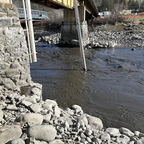
Monitoring equipment in the Klamath River
The pipes suspended from the bridge house monitoring equipment that records real-time water-quality data in the Klamath River (11511990) during the Klamath dam removal.
The pipes suspended from the bridge house monitoring equipment that records real-time water-quality data in the Klamath River (11511990) during the Klamath dam removal.
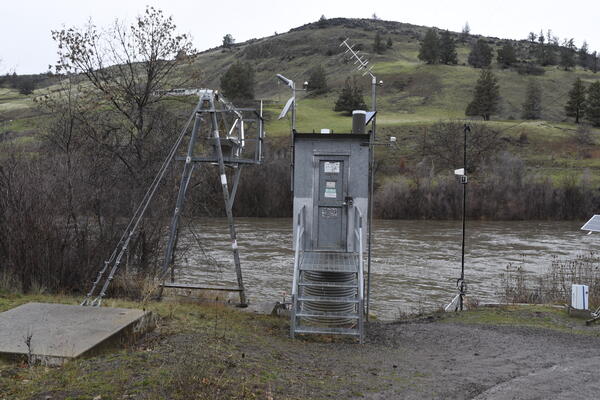
USGS Klamath River streamgage below Iron Gate
USGS streamgage 11516530 on the Klamath River below Iron Gate Dam in Siskiyou County, California, monitors real-time streamflow and water temperature for a 4,630-square-mile basin.
USGS streamgage 11516530 on the Klamath River below Iron Gate Dam in Siskiyou County, California, monitors real-time streamflow and water temperature for a 4,630-square-mile basin.

USGS technician collects water samples from a dock to analyze for phytoplankton and phycotoxins (Bay Point, CA; January 10, 2024).
USGS technician collects water samples from a dock to analyze for phytoplankton and phycotoxins (Bay Point, CA; January 10, 2024).USGS technician collects water samples from a dock to analyze for phytoplankton and phycotoxins (Bay Point, CA; January 10, 2024).
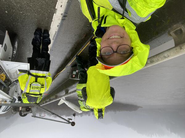
Sediment sampling on the Klamath River during dam removal
Sediment sampling on the Klamath River during dam removalA field crew member stops to smile for a photo during sediment sampling on the Klamath River. The sediment sampler is lowered from a truck-mounted crane across the channel to collect measurements at multiple locations.

Noah Hoffman, physical scientist, USGS California Water Science Center, installing soil moisture probe
Noah Hoffman, physical scientist, USGS California Water Science Center, installing soil moisture probeThe U.S. Geological Survey (USGS) California Water Science Center is employing specific types of soil moisture probes to monitor watersheds, creeks, and streams as part of their hydrological studies and environmental monitoring efforts.