1984 International Remote Sensing Workshop Poster - 72dpi
1984 International Remote Sensing Workshop Poster - 72dpi1984 International Remote Sensing Workshop Poster

Official websites use .gov
A .gov website belongs to an official government organization in the United States.
Secure .gov websites use HTTPS
A lock () or https:// means you’ve safely connected to the .gov website. Share sensitive information only on official, secure websites.
Peruse our selection of remote sensing and Earth science imagery below.

1984 International Remote Sensing Workshop Poster
1984 International Remote Sensing Workshop Poster

Clouds encircle the lofty rim of Africa's Mount Elgon, a huge, long-extinct volcano on the border between Uganda and Kenya. The solitary volcano has one of the world's largest intact calderas, a cauldron-like central depression.
Clouds encircle the lofty rim of Africa's Mount Elgon, a huge, long-extinct volcano on the border between Uganda and Kenya. The solitary volcano has one of the world's largest intact calderas, a cauldron-like central depression.

Landsat 4's first light image captured eastern Lake Erie, and the cities of Toledo, Detroit, and Windsor on July 25, 1982. Although the Landsat program had been collecting images of the Earth since 1972, this was the first time that the data could be depicted as a natural color image due to the new Thematic Mapper sensor onboard Landsat 4.
Landsat 4's first light image captured eastern Lake Erie, and the cities of Toledo, Detroit, and Windsor on July 25, 1982. Although the Landsat program had been collecting images of the Earth since 1972, this was the first time that the data could be depicted as a natural color image due to the new Thematic Mapper sensor onboard Landsat 4.

The first Landsat 4 image was acquired over western Lake Erie on July 25, 1982, just 9 days after launch. This image shows the Detroit River dividing the metropolitan areas of Detroit, Michigan and Windsor, Ontario while acting as a strait between Lake Erie and Lake St. Clair.
The first Landsat 4 image was acquired over western Lake Erie on July 25, 1982, just 9 days after launch. This image shows the Detroit River dividing the metropolitan areas of Detroit, Michigan and Windsor, Ontario while acting as a strait between Lake Erie and Lake St. Clair.
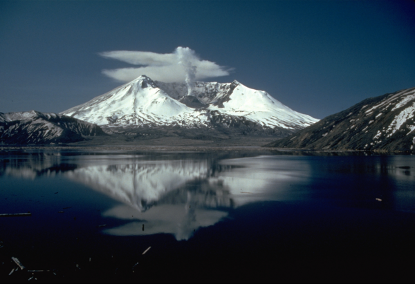
This photo shows Mount St. Helens in 1982, 2 years after the volcano erupted on May 18, 1980. Spirit Lake is in the foreground.
Compare this picture to one taken in 1980 before the eruption to see the changes made to the landscape.
This photo shows Mount St. Helens in 1982, 2 years after the volcano erupted on May 18, 1980. Spirit Lake is in the foreground.
Compare this picture to one taken in 1980 before the eruption to see the changes made to the landscape.
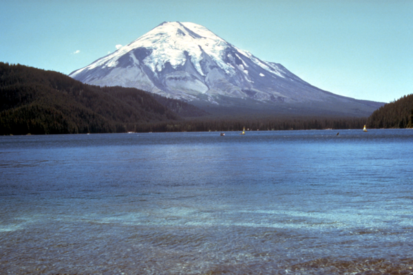
This photo shows Mount St. Helens before the volcano erupted on May 18, 1980. Spirit Lake is in the foreground.
Compare this picture to one taken in 1982 to see the changes made by the eruption.
This photo shows Mount St. Helens before the volcano erupted on May 18, 1980. Spirit Lake is in the foreground.
Compare this picture to one taken in 1982 to see the changes made by the eruption.

USGS provides remote sensing science training for visitors. This is a field trip to Badlands National Park.
USGS provides remote sensing science training for visitors. This is a field trip to Badlands National Park.

USGS provides remote sensing science training for visitors in 1979.
Captured with an Olympus Digital Camera.
USGS provides remote sensing science training for visitors in 1979.
Captured with an Olympus Digital Camera.

USGS provides remote sensing science training for visitors. This image shows visitors seeing Mount Rushmore.
USGS provides remote sensing science training for visitors. This image shows visitors seeing Mount Rushmore.

USGS EROS provides remote sensing science training for visitors in 1979. This is a man using a stereoscope to look at satellite images.
USGS EROS provides remote sensing science training for visitors in 1979. This is a man using a stereoscope to look at satellite images.

One of Landsat 3’s first images, captured by the Multispectral Scanner (MSS) 4 days after launch, features a slice of Northern California on March 7, 1978. San Jose sits in Santa Clara Valley touching the southernmost portion of San Francisco. This image showcases the urbanization of the valley, which exploded in the 1970s as Silicon Valley grew.
One of Landsat 3’s first images, captured by the Multispectral Scanner (MSS) 4 days after launch, features a slice of Northern California on March 7, 1978. San Jose sits in Santa Clara Valley touching the southernmost portion of San Francisco. This image showcases the urbanization of the valley, which exploded in the 1970s as Silicon Valley grew.

In-house data processing systems at USGS EROS, shown here in 1976, supported research based on aerial photography and satellite data.
In-house data processing systems at USGS EROS, shown here in 1976, supported research based on aerial photography and satellite data.
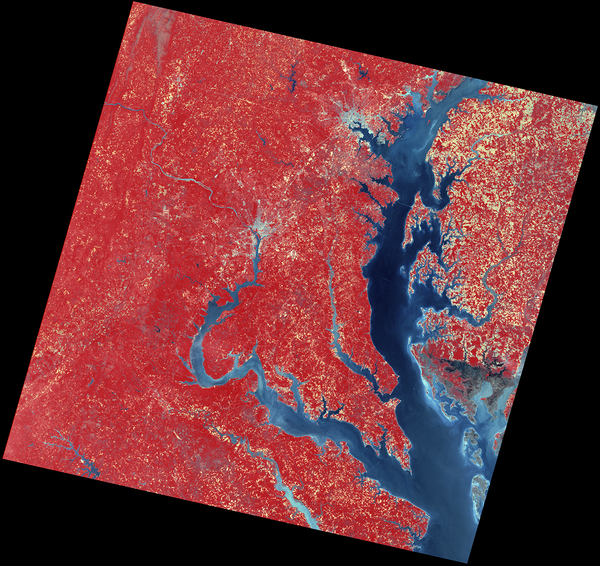
The Multispectral Scanner (MSS) onboard the Landsat 2 satellite captured the data used to create this color infrared image on May 15,1975. Chesapeake Bay leads up the image to Baltimore, Maryland, and the Potomac River leads west and north up to Washington, DC.
The Multispectral Scanner (MSS) onboard the Landsat 2 satellite captured the data used to create this color infrared image on May 15,1975. Chesapeake Bay leads up the image to Baltimore, Maryland, and the Potomac River leads west and north up to Washington, DC.

Landsat 2’s first light image captured Drayton Valley in Alberta, Canada on January 24, 1975. Located along Canadian Highway 22, also known as Cowboy Trail, the town’s original economy thrived on faming and logging. The discovery of the Pembina oil field in 1953 contributed to explosive growth in the sparsely populated area, w
Landsat 2’s first light image captured Drayton Valley in Alberta, Canada on January 24, 1975. Located along Canadian Highway 22, also known as Cowboy Trail, the town’s original economy thrived on faming and logging. The discovery of the Pembina oil field in 1953 contributed to explosive growth in the sparsely populated area, w

Example of the Landsat 1-5 MSS Collection 2 level-1 product. This Landsat 1 image was acquired on June 26, 1974 near Fallon, Nevada and is shown as a false color composite using the near-infrared, red, and green bands (bands 3,2,1).
Example of the Landsat 1-5 MSS Collection 2 level-1 product. This Landsat 1 image was acquired on June 26, 1974 near Fallon, Nevada and is shown as a false color composite using the near-infrared, red, and green bands (bands 3,2,1).
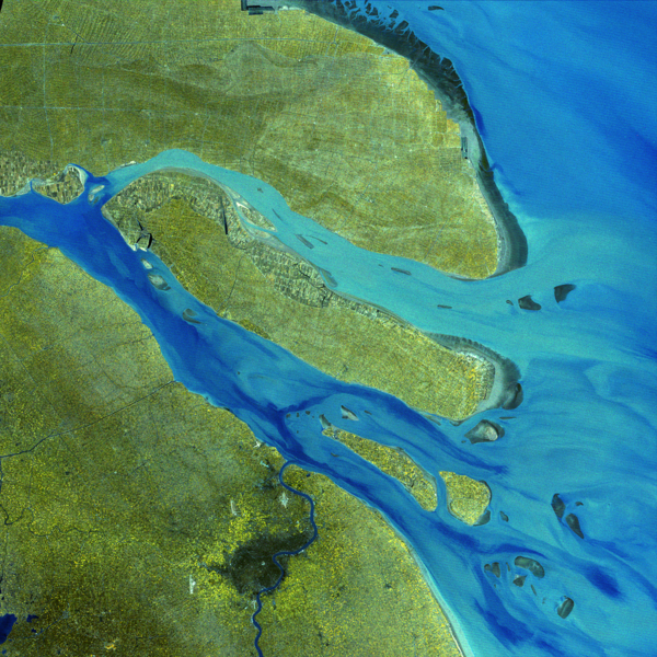
This false-color image, captured by Landsat 1 on February 13, 1974, shows the landscape around Shanghai and the Yangtze River Delta. Using bands 7 (near-infrared), 6 (red), and 5 (green), the image highlights water in dark blue, sediment-laden channels in lighter shades of blue, and vegetation in shades of yellow and green.
This false-color image, captured by Landsat 1 on February 13, 1974, shows the landscape around Shanghai and the Yangtze River Delta. Using bands 7 (near-infrared), 6 (red), and 5 (green), the image highlights water in dark blue, sediment-laden channels in lighter shades of blue, and vegetation in shades of yellow and green.

Landsat 2’s first light image features a slice of Alberta, Canada, captured on January 24, 1975 on Path 047 Row 023. This false color images uses two near infrared bands and the red band (Bands 7,6,5).
Learn more about Landsat 2 by visiting the Landsat 2 Mission Web Page
Landsat 2’s first light image features a slice of Alberta, Canada, captured on January 24, 1975 on Path 047 Row 023. This false color images uses two near infrared bands and the red band (Bands 7,6,5).
Learn more about Landsat 2 by visiting the Landsat 2 Mission Web Page
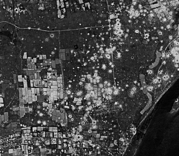
A HEXAGON satellite image from the Quang Tri province of Vietnam shows numerous bomb craters. Declassified in 2011, HEXAGON, also named KH-9, provided imagery from 1971 to 1984. This image was acquired on March 20, 1973.
A HEXAGON satellite image from the Quang Tri province of Vietnam shows numerous bomb craters. Declassified in 2011, HEXAGON, also named KH-9, provided imagery from 1971 to 1984. This image was acquired on March 20, 1973.
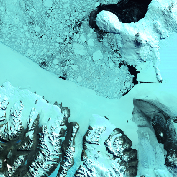
This Landsat 1 image, acquired on January 13, 1973, offers one of the earliest satellite perspectives of Antarctica’s Ross Island and McMurdo Sound. Captured using the Multispectral Scanner’s (MSS) near-infrared, red, and green bands (6, 5, 4), the image highlights the region's glaciated terrain, floating sea ice, and volcanic peaks.
This Landsat 1 image, acquired on January 13, 1973, offers one of the earliest satellite perspectives of Antarctica’s Ross Island and McMurdo Sound. Captured using the Multispectral Scanner’s (MSS) near-infrared, red, and green bands (6, 5, 4), the image highlights the region's glaciated terrain, floating sea ice, and volcanic peaks.

An artist's rendering of the pioneering Earth observation satellite that launched the Landsat program, providing critical data for monitoring land cover and environmental changes since 1972.
Learn more about the Landsat Mission
An artist's rendering of the pioneering Earth observation satellite that launched the Landsat program, providing critical data for monitoring land cover and environmental changes since 1972.
Learn more about the Landsat Mission
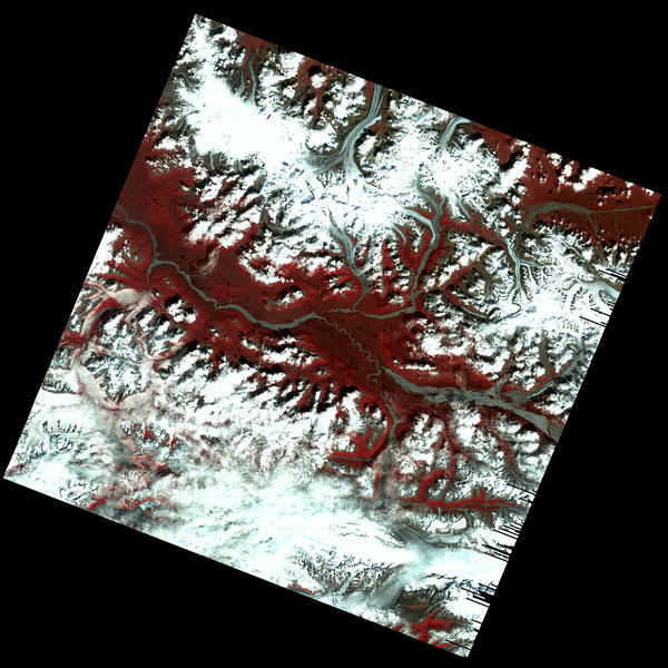
This early Landsat 1 image, acquired on July 31, 1972, captures the Kennicott, Nabesna, and Barnard Glaciers in southeastern Alaska—just a week after the satellite’s launch. Using bands 6, 5, and 4, the image reveals glacial ice, rugged mountain terrain, and braided rivers within the Wrangell–St. Elias region.
This early Landsat 1 image, acquired on July 31, 1972, captures the Kennicott, Nabesna, and Barnard Glaciers in southeastern Alaska—just a week after the satellite’s launch. Using bands 6, 5, and 4, the image reveals glacial ice, rugged mountain terrain, and braided rivers within the Wrangell–St. Elias region.