
Scientists at EROS look at local and global drivers of land-use change to project how different scenarios will impact and change landscapes. Using the FOREcasting SCEnarios of Land-use Change (FORE-SCE) modeling framework provides spatially explicit projections of future land-use and land-cover change.
USGS scientists have a long tradition of providing high-quality, consistent, and relevant land-cover data for the United States, using our archive of current and historical remote sensing data. The National Land Cover Database (NLCD) provides consistent, spatially explicit, periodically updated maps of land cover for the United States, with mapped dates for 1992, 2001, 2006, and 2011 (in progress). The USGS Land Cover Trends project has mapped and analyzed historical land-cover change from 1973 to 2000 using the Landsat satellite image archive. The Landscape Fire and Resource Management Planning Tools Project (LANDFIRE) provides multiple landscape attributes to support land managers and modelers. Together, these data provide a suite of data and information on current and recent historical land-cover change for the United States.
Scientists at EROS are using their experience in mapping land cover and their knowledge of land-cover change processes to temporally extend these databases beyond the dates of available remote sensing data. Using the EROS FOREcasting SCEnarios of Land-Cover (FORE-SCE) model, EROS scientists are modeling land-cover change both into the future, using scenario-based modeling approaches, and for "backcasting" land cover for historical periods. In combination with USGS remote sensing based land-cover data, EROS' modeling efforts result in consistent, annual land-cover maps from 1938 through 2100, with multiple scenarios of potential land cover for future periods.
Modeling Examples
- Bismarck, North Dakota - A1B Scenario
- Washington / Baltimore Area - A2 Scenario
- Phoenix, Arizona - B1 Scenario
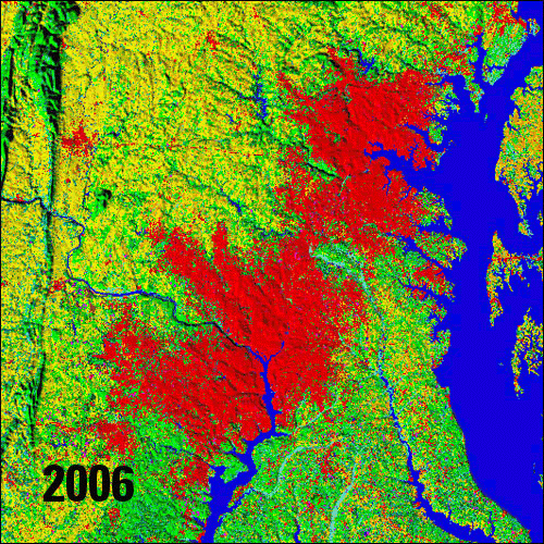
- Alexandria, Louisiana - B2 Scenario
For more on Land Cover Modeling, visit the full site.
Scientists at EROS look at local and global drivers of land-use change to project how different scenarios will impact and change landscapes. Using the FOREcasting SCEnarios of Land-use Change (FORE-SCE) modeling framework provides spatially explicit projections of future land-use and land-cover change.
USGS scientists have a long tradition of providing high-quality, consistent, and relevant land-cover data for the United States, using our archive of current and historical remote sensing data. The National Land Cover Database (NLCD) provides consistent, spatially explicit, periodically updated maps of land cover for the United States, with mapped dates for 1992, 2001, 2006, and 2011 (in progress). The USGS Land Cover Trends project has mapped and analyzed historical land-cover change from 1973 to 2000 using the Landsat satellite image archive. The Landscape Fire and Resource Management Planning Tools Project (LANDFIRE) provides multiple landscape attributes to support land managers and modelers. Together, these data provide a suite of data and information on current and recent historical land-cover change for the United States.
Scientists at EROS are using their experience in mapping land cover and their knowledge of land-cover change processes to temporally extend these databases beyond the dates of available remote sensing data. Using the EROS FOREcasting SCEnarios of Land-Cover (FORE-SCE) model, EROS scientists are modeling land-cover change both into the future, using scenario-based modeling approaches, and for "backcasting" land cover for historical periods. In combination with USGS remote sensing based land-cover data, EROS' modeling efforts result in consistent, annual land-cover maps from 1938 through 2100, with multiple scenarios of potential land cover for future periods.
Modeling Examples
- Bismarck, North Dakota - A1B Scenario
- Washington / Baltimore Area - A2 Scenario
- Phoenix, Arizona - B1 Scenario
- Alexandria, Louisiana - B2 Scenario
For more on Land Cover Modeling, visit the full site.