Mt. Rainier with research boat in foreground on lake, Mt. Rainier NP
Mt. Rainier with research boat in foreground on lake, Mt. Rainier NPMt. Rainier with research boat in foreground on lake, Mt. Rainier NP

Official websites use .gov
A .gov website belongs to an official government organization in the United States.
Secure .gov websites use HTTPS
A lock () or https:// means you’ve safely connected to the .gov website. Share sensitive information only on official, secure websites.
If you are unable to access or download a product, email fresc_outreach@usgs.gov a request, including the full citation, or call (541) 750-1030.

Mt. Rainier with research boat in foreground on lake, Mt. Rainier NP
Mt. Rainier with research boat in foreground on lake, Mt. Rainier NP

Unknown lake in Mt. Rainier National Park

Wind turbines around a farm house

A forested wetland in Mount Rainier National Park

American avocet chicks resting on the shore in Malheur Lake National Wildlife Refuge. The chicks were observed by USGS scientists conducting environmental contaminant research.
American avocet chicks resting on the shore in Malheur Lake National Wildlife Refuge. The chicks were observed by USGS scientists conducting environmental contaminant research.

A Pacific chorus frog (also known as Pacific tree frog) perched in reed canary grass in the Finley National Wildlife Refuge in Oregon.
A Pacific chorus frog (also known as Pacific tree frog) perched in reed canary grass in the Finley National Wildlife Refuge in Oregon.

An American avocet feeding in Summer Lake, a saline lake in Oregon. The avocet was photographed while conducting research on environmental contaminants in the Great Basin.
An American avocet feeding in Summer Lake, a saline lake in Oregon. The avocet was photographed while conducting research on environmental contaminants in the Great Basin.

Honey Creek in southeastern Oregon

Little Blitzen River in southeastern Oregon

Map of historic and current sage-grouse range in 2000, provided as a download from the old USGS Sagemap website.
Map of historic and current sage-grouse range in 2000, provided as a download from the old USGS Sagemap website.

A road-stream crossing, or culvert, in the Pacific Northwest. Culverts allow streams and fish to pass under roads and maintain habitat connectivity.
A road-stream crossing, or culvert, in the Pacific Northwest. Culverts allow streams and fish to pass under roads and maintain habitat connectivity.

Black-necked stilts feeding in the Summer Lake Wildlife Area in Oregon. The stilts were observed by USGS scientists conducting environmental contaminant research.
Black-necked stilts feeding in the Summer Lake Wildlife Area in Oregon. The stilts were observed by USGS scientists conducting environmental contaminant research.

The turbid waters of the Elwha River and the coastal waters of the Strait of Juan de Fuca mix directly offshore of the river mouth, forming a large coastal plume. This plume is easily identified by the cloudiness of the water (or "turbidity") resulting from sediment discharged by the river. Two large dams on the Elwha River are being incrementally r
The turbid waters of the Elwha River and the coastal waters of the Strait of Juan de Fuca mix directly offshore of the river mouth, forming a large coastal plume. This plume is easily identified by the cloudiness of the water (or "turbidity") resulting from sediment discharged by the river. Two large dams on the Elwha River are being incrementally r

The turbid waters of the Elwha River and the coastal waters of the Strait of Juan de Fuca mix directly offshore of the river mouth, forming a large coastal plume. This plume is easily identified by the cloudiness of the water (or "turbidity") resulting from sediment discharged by the river. Two large dams on the Elwha River were incrementally r
The turbid waters of the Elwha River and the coastal waters of the Strait of Juan de Fuca mix directly offshore of the river mouth, forming a large coastal plume. This plume is easily identified by the cloudiness of the water (or "turbidity") resulting from sediment discharged by the river. Two large dams on the Elwha River were incrementally r

Barred owls (Strix varia) have expanded their geographic range from eastern to western North America. Their newly expanded range now completely overlaps that of the federally threatened northern spotted owl (S. occidentalis caurina).
Barred owls (Strix varia) have expanded their geographic range from eastern to western North America. Their newly expanded range now completely overlaps that of the federally threatened northern spotted owl (S. occidentalis caurina).

A sleet storm approaches the sagebrush habitat at the south end Stinkingwater Mountians near Warm Springs Reservoir in eastern Oregon
A sleet storm approaches the sagebrush habitat at the south end Stinkingwater Mountians near Warm Springs Reservoir in eastern Oregon

Methow River near Winthrop, WA in fall of 2011. USGS researchers are creating a decision support model to help the BLM determine how alternative restoration strategies might affect threatened salmon and steelhead fish populations.
Methow River near Winthrop, WA in fall of 2011. USGS researchers are creating a decision support model to help the BLM determine how alternative restoration strategies might affect threatened salmon and steelhead fish populations.

Two USGS scientists set up equipment to measure sagebrush in a common garden experiment in the Great Basin, Idaho
Two USGS scientists set up equipment to measure sagebrush in a common garden experiment in the Great Basin, Idaho
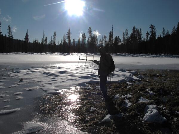
A USGS scientist is using radio telemetry to track the overwintering locations of Oregon spotted frogs at Gold Lake bog in Oregon. Oregon spotted frogs spend nearly half the year at overwintering locations, which can include springs, beaver channels, and crevices in lava rock.
A USGS scientist is using radio telemetry to track the overwintering locations of Oregon spotted frogs at Gold Lake bog in Oregon. Oregon spotted frogs spend nearly half the year at overwintering locations, which can include springs, beaver channels, and crevices in lava rock.

Filtering stream water to collect environmental DNA from stream amphibians
Filtering stream water to collect environmental DNA from stream amphibians

Collecting a 1-liter water sample in the Boise River for eDNA analysis (Boise, ID)"
Collecting a 1-liter water sample in the Boise River for eDNA analysis (Boise, ID)"