
Forest
Forest
Filter Total Items: 25
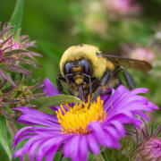
Science for effective pollinator conservation and improved food security
Pollinators, including bees, flies, butterflies, bats, birds, and other animals, are critically important to U.S. ecosystems and agriculture. Recent reports of declines of pollinator species have led to widespread actions to conserve pollinator habitat and recover imperiled species, but resource managers need accurate data and science to support management actions. USGS pollinator research helps...
Ecosystem change science in support of wildfire management, water conservation, public land reclamation, and food security
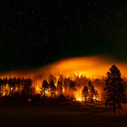
FORT researchers provide sound science to support the Department of the Interior in its efforts to manage wildfires, conserve water, reclaim public lands for multiple uses, and promote food security. This research is developed in partnership with resource managers from local, State, Federal and Tribal governments, industry, and nongovernmental organizations, empowering local and rural communities...

Assessing vegetation and avian community response to juniper reduction treatments in Southwest Montana
The Southwest Montana Sagebrush Partnership (SMSP) team, including land managers, landowners, and scientists, is implementing conifer removal projects encompassing over 55,000 acres of private, state, and federal lands throughout the region. To date, little place-based information exists regarding likely vegetation and bird responses to such treatments in Southwestern Montana. To address this...

Impacts of changing climate and disturbance regimes on forest ecosystem resilience in the Southern Rocky Mountains
Climate-driven forest disturbances, particularly drought-induced tree mortality and large high-severity fires from increasingly warm and dry conditions, are altering forest ecosystems and the ecosystem services society depends on (e.g., water supplies) in the Southern Rockies and across the Western U.S. We will combine unique, long-term place-based ecological data, diverse methods (e.g., paleo...

Effects of global change on alpine and subalpine ecosystems
Atmospheric nitrogen deposition, changing environmental patterns, and recreation are rapidly altering high elevation ecosystems. This project will evaluate long-term biogeochemical, hydrological, and ecological trends in Rocky Mountain National Park to understand the causes and rates of change in alpine and subalpine waters, soils, and vegetation. Resource managers of high-elevation, protected...

New Mexico Tree-Ring Science
Tree-ring science is a component of our interdisciplinary ecological research program that focuses on the effects of drought and human land use on forest ecology, fire ecology, and ecohydrology.

The New Mexico Landscapes Field Station
The New Mexico Landscapes Field Station is a place-based, globally connected, ecological research group that studies ecosystem and wildlife dynamics, working with land managers, community leaders, and Tribes to deliver solutions that foster the linked health of human and natural systems. For over three decades, we have focused on shifting research needs from forest watershed health to wildlife...

New Mexico Landscapes Field Station: Forest Ecosystem Research
Below are ongoing or completed research projects related to forest ecosystems at the New Mexico Landscapes Field Station.

New Mexico Landscapes Field Station: Fire Research
Below are ongoing or completed research projects related to fire at the New Mexico Landscapes Field Station.

New Mexico Landscapes Field Station: People
Staff associated with the New Mexico Landscapes Field Station.

Synthesis and Forecasts of Piñon-Juniper Woodland Die-off
Drought, hotter temperatures, and insect outbreaks are affecting dryland ecosystems across the globe. Pinon-juniper (PJ) woodlands are a widespread vegetation type common to drylands of North America, which have been hit particularly hard by a warming climate. Specifically, mass tree die-off events are transforming PJ woodland structure, composition, and distributions. This project aims to...

Prioritizing conifer removal for multi-species outcomes
Wildlife management is frequently conducted to benefit a single species, despite evidence that suggests such an approach often fails to adequately address the needs of other species within a region. Managing for multiple species’ habitat requirements is even more critical when large scale habitat management efforts change vegetation conditions at the landscape scale, or when management occurs at...