
Land Management Practices
Land Management Practices
Filter Total Items: 83

Recommendations for conducting landscape assessments to inform decision making on multiple-use public lands
Landscape assessments have been proposed as a mechanism for informing conservation and natural resource management actions at broad scales. We are documenting the process used in a large effort to conduct 14 such assessments across the western United States, and evaluating how the assessments were used in subsequent land use plans. In this project, we seek to identify methods and characteristics...

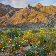
Prioritizing restoration and conservation of Wyoming’s sagebrush ecosystems for wildlife and sagebrush connectivity
To support strategic ecosystem management across the imperiled sagebrush steppe in Wyoming, USA, we developed an extension of the Prioritizing Restoration of Sagebrush Ecosystems Tool (PReSET). Our expanded tool leverages emerging spatial data resources to provide a structured but customizable set of scenarios that can guide landscape-scale planning efforts by prioritizing conservation and...

Prioritizing Restoration of Sagebrush Ecosystems Tool (PReSET): A USGS-facilitated Decision-support Tool for Sagebrush Ecosystem Conservation and Restoration Actions
Sagebrush ecosystems represent one of the most imperiled systems in North America and face continued and widespread degradation due to multiple factors including invasive species and increased human development. Effective sagebrush management must consider how to best conserve and restore habitats to stem the decline of species that rely on them, especially given limited conservation resources. To...

USGS Science Syntheses for Public Lands Management
Scientific information is fundamental to understanding how proposed actions on public lands may impact the environment. Development of new science is occurring at rates that can make it challenging for biologists, resource managers, decision makers, private landowners, and other stakeholders to ensure they are using up-to-date, high-quality science information to inform their decisions. Further...
Skill-building workshops for researchers on the coproduction of actionable science
Public lands management requires the use of science, but agency staff rarely have time to stay current with all the science on management-relevant topics, especially as articles are published at an ever-increasing rate. In this new series of learning modules, we aim to provide scientists with essential tools, skills, and strategies for coproducing actionable science products with and for federal...
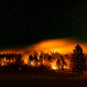
Ecosystem change science in support of wildfire management, water conservation, public land reclamation, and food security
FORT researchers provide sound science to support the Department of the Interior in its efforts to manage wildfires, conserve water, reclaim public lands for multiple uses, and promote food security. This research is developed in partnership with resource managers from local, State, Federal and Tribal governments, industry, and nongovernmental organizations, empowering local and rural communities...

Social and economic analysis research in support of public safety, outdoor recreation, and economic growth
FORT researchers provide sound science to support the Department of the Interior in its efforts to reduce the risks wildfires pose to people and property, expand outdoor recreation and tourism opportunities, and promote economic decision making in public lands management. This research is developed in partnership with resource managers from local, State, Federal and Tribal governments, industry...

Land management research in support of streamlined energy development, economic growth, and wildfire management
FORT researchers provide sound science to support the Department of the Interior in its efforts to streamline reliable energy development, enhance cost efficiency in public lands management, and manage fire-prone habitats for public safety. This research is developed in partnership with resource managers from local, State, Federal and Tribal governments, industry, and nongovernmental organizations...

Developing science syntheses to facilitate climate-informed land management decisions and NEPA analyses on rangelands in the sagebrush biome
The National Environmental Policy Act (NEPA) requires federal public land managers to assess potential environmental impacts of proposed actions. The USGS, Bureau of Land Management, US Fish and Wildlife Service, Colorado State University, and North Central Climate Adaptation Science Center are working together to develop science syntheses that can facilitate considerations of climate change in...

Human Dimensions of Resource Management
Human dimensions in the context of natural resource management refers to understanding attitudes, preferences, and behaviors of American citizens in order to improve conservation and management of public lands and waters. Human Dimensions at the FORT also includes understanding the users and applications of data and technology in the context of natural resource management.

Feasibility of Remote Sensing Data Sets for Evaluation of Next Generation Fire Behavior Models
U.S. Geological Survey (USGS) scientists are working with the U.S. Department of Defense (DoD) Environmental Security Technology Certification Program (ESTCP) to advance efforts to deploy next generation fire behavior models through a research-to-operations transition to enable land managers to use advanced modeling tools for real-time decision making. As part of this effort, USGS is leading an...

Fish and wildlife science in support of heritage preservation, efficient decision making, wild ungulate management, and outdoor recreation
FORT researchers provide sound science to support the Department of Interior in its efforts to preserve American heritage, streamline species listing decisions and promote species recovery, manage wild horses and burros using efficient, cost-effective tools, and sustain hunting and fishing on public lands. This research is developed in partnership with resource managers from local, State, Federal...