Pennington Mountain Critical Minerals Earth MRI Geophysical Scan
Pennington Mountain Critical Minerals Earth MRI Geophysical ScanThe anomaly at Pennington Mountain is visible in the geophysical data collected in aerial surveys conducted in 2021.

Official websites use .gov
A .gov website belongs to an official government organization in the United States.
Secure .gov websites use HTTPS
A lock () or https:// means you’ve safely connected to the .gov website. Share sensitive information only on official, secure websites.
Images

The anomaly at Pennington Mountain is visible in the geophysical data collected in aerial surveys conducted in 2021.
The anomaly at Pennington Mountain is visible in the geophysical data collected in aerial surveys conducted in 2021.
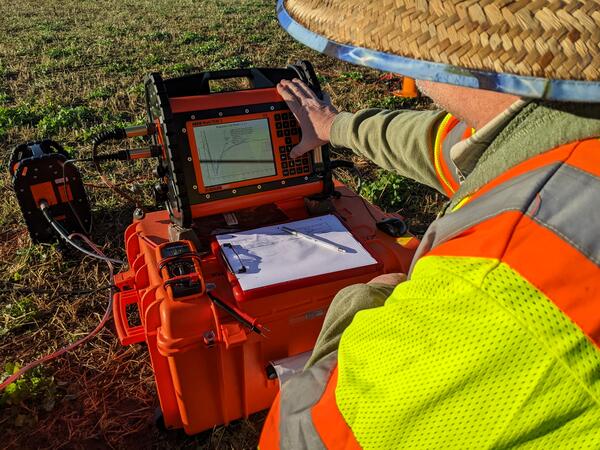
The return signal from the electromagnetic pulse administered to the ground by the WalkTEM (transient electromagnetics (TEM)) instrument is displayed on the instrument during field data collection at a site in the Illinois River Basin.
The return signal from the electromagnetic pulse administered to the ground by the WalkTEM (transient electromagnetics (TEM)) instrument is displayed on the instrument during field data collection at a site in the Illinois River Basin.
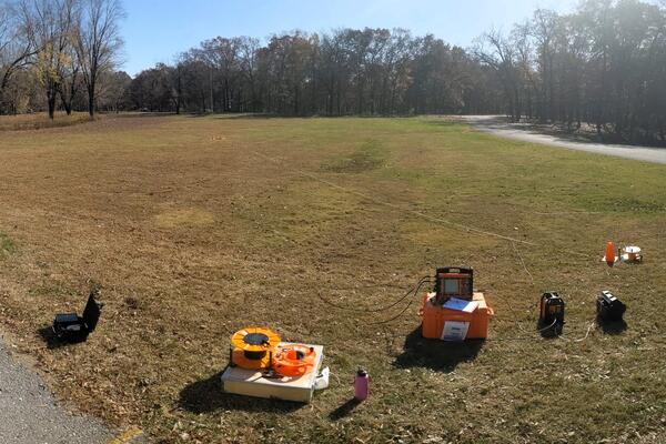
A ground-based geophysics survey using WalkTEM (transient electromagnetics (TEM)) is set up and ready to initiate at a site in the Illinois River Basin.
A ground-based geophysics survey using WalkTEM (transient electromagnetics (TEM)) is set up and ready to initiate at a site in the Illinois River Basin.
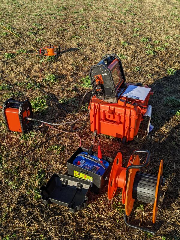
WalkTEM (transient electromagnetics (TEM)) instrument is staged for collection of ground-based electromagnetic survey data at a site in the Illinois River Basin.
WalkTEM (transient electromagnetics (TEM)) instrument is staged for collection of ground-based electromagnetic survey data at a site in the Illinois River Basin.

A Piper Navajo fixed-wing aircraft with rear facing stinger magnetometer. Credit: New-Sense Geophysics Limited
A Piper Navajo fixed-wing aircraft with rear facing stinger magnetometer. Credit: New-Sense Geophysics Limited

Screenshot of interactive Arrastra Gulch, Silverton, CO 3D Data Viewer, available at https://geonarrative.usgs.gov/silverton/.
Screenshot of interactive Arrastra Gulch, Silverton, CO 3D Data Viewer, available at https://geonarrative.usgs.gov/silverton/.

An AS350 helicopter with forward facing stinger magnetometer. Credit: New-Sense Geophysics Limited
An AS350 helicopter with forward facing stinger magnetometer. Credit: New-Sense Geophysics Limited

Pioneer Mountains metamorphic core complex – gray peaks (middle) are in the lower plate that is separated by a detachment fault on both sides, overlain by Ordovician through Silurian yellow metasedimentary units (right and middle left) that make up the middle plate which is separated by another detachment fault overlain by later Paleozoic units (left).
Pioneer Mountains metamorphic core complex – gray peaks (middle) are in the lower plate that is separated by a detachment fault on both sides, overlain by Ordovician through Silurian yellow metasedimentary units (right and middle left) that make up the middle plate which is separated by another detachment fault overlain by later Paleozoic units (left).

Reference reflectance site, a remote playa in Black Rock Desert, NV. The Hyperspectral Imaging of Mineral Resources from New and Old Origins project is using such sites to calibrate and validate data collected by imaging spectrometers (hyperspectral imagers) from aircraft and spacecraft.
Reference reflectance site, a remote playa in Black Rock Desert, NV. The Hyperspectral Imaging of Mineral Resources from New and Old Origins project is using such sites to calibrate and validate data collected by imaging spectrometers (hyperspectral imagers) from aircraft and spacecraft.

USGS scientists Todd Hoefen (left) and John Meyer (right) make spectral measurements with a field portable spectrometer at a remote playa in Black Rock Desert, NV. These measurements are used to calibrate and validate data collected by imaging spectrometers (hyperspectral imagers) from aircraft and spacecraft.
USGS scientists Todd Hoefen (left) and John Meyer (right) make spectral measurements with a field portable spectrometer at a remote playa in Black Rock Desert, NV. These measurements are used to calibrate and validate data collected by imaging spectrometers (hyperspectral imagers) from aircraft and spacecraft.

A helicopter with a boom that contains sensitive equipment for conducting airborne geophysical surveys.
A helicopter with a boom that contains sensitive equipment for conducting airborne geophysical surveys.

Airborne geophysical surveys make use of a boom with sensitive equipment installed on small aircraft.
Airborne geophysical surveys make use of a boom with sensitive equipment installed on small aircraft.

The short video is of a post laser ablation crater using a nanosecond 193nm laser ablation system of a glass slide using a 210 micron spot diameter and 250 shots. It shows a flat bottom crater indicative of a homogenized laser beam, though the measured diameter of the crater appears to be 25 microns smaller the diameter set. The 3D crater image was creat
The short video is of a post laser ablation crater using a nanosecond 193nm laser ablation system of a glass slide using a 210 micron spot diameter and 250 shots. It shows a flat bottom crater indicative of a homogenized laser beam, though the measured diameter of the crater appears to be 25 microns smaller the diameter set. The 3D crater image was creat

USGS scientist Todd Hoefen makes spectral measurements with a field portable spectrometer at a remote playa in Black Rock Desert, NV. These measurements are used to calibrate and validate data collected by imaging spectrometers (hyperspectral imagers) from aircraft and spacecraft.
USGS scientist Todd Hoefen makes spectral measurements with a field portable spectrometer at a remote playa in Black Rock Desert, NV. These measurements are used to calibrate and validate data collected by imaging spectrometers (hyperspectral imagers) from aircraft and spacecraft.

Pre-historic Nez Perce trail from the Wallowa Mountains of Oregon to the Great Plains to hunt bison. Ponderosa pine shows scars from the harvesting of cambium as a food source on those trips.
Pre-historic Nez Perce trail from the Wallowa Mountains of Oregon to the Great Plains to hunt bison. Ponderosa pine shows scars from the harvesting of cambium as a food source on those trips.

Historic Bayhorse mining district millsite in foreground to thick dolostone cliffs of disputed age--either Lower Ordovician or Neoproterozoic, a difference in interpretations of about 100 million years ago. The Bayhorse Mining district was one of the longest-running silver and lead producers in Idaho.
Historic Bayhorse mining district millsite in foreground to thick dolostone cliffs of disputed age--either Lower Ordovician or Neoproterozoic, a difference in interpretations of about 100 million years ago. The Bayhorse Mining district was one of the longest-running silver and lead producers in Idaho.

Laser ablation sport sizes: 65 µm, 35 µm, 10 µm, 5 µm, and 3 µm. The resolution approaches 3 micron resolution for sulfur isotope ratios measurements in sulfides.
Laser ablation sport sizes: 65 µm, 35 µm, 10 µm, 5 µm, and 3 µm. The resolution approaches 3 micron resolution for sulfur isotope ratios measurements in sulfides.

Multi Collector ICP Mass Spectrometer (MC-ICP-MS) plasma shield upgrade between models NP2 to NP3 (Nu Instruments).
Multi Collector ICP Mass Spectrometer (MC-ICP-MS) plasma shield upgrade between models NP2 to NP3 (Nu Instruments).

Survey area for low-flying helicopter soon to be visible in six Montana counties, including Helena, the Elkhorn Mountains, Bull Mountain and the Tobacco Root Mountains.
Survey area for low-flying helicopter soon to be visible in six Montana counties, including Helena, the Elkhorn Mountains, Bull Mountain and the Tobacco Root Mountains.

Helicopter conducting low-level flights. Image courtesy Sander Geophysics Ltd.
Helicopter conducting low-level flights. Image courtesy Sander Geophysics Ltd.

Geologists in the field at Pennington Mountain. The orange instrument is a portable gamma spectrometer. University of Maine-Presque Isle professor Chunzeng Wang (the lead author) is in front, Preston Bass is carrying the meter.
Geologists in the field at Pennington Mountain. The orange instrument is a portable gamma spectrometer. University of Maine-Presque Isle professor Chunzeng Wang (the lead author) is in front, Preston Bass is carrying the meter.