



USGS New Jersey WSC Tide Network Station 014090110, Barnegat Bay at Waretown, after Storm Hardening upgrades following Hurricane Sandy
Images
New Jersey Water Science Center Image File
Filter Total Items: 312

Waretown2019
USGS New Jersey WSC Tide Network Station 014090110, Barnegat Bay at Waretown, after Storm Hardening upgrades following Hurricane Sandy
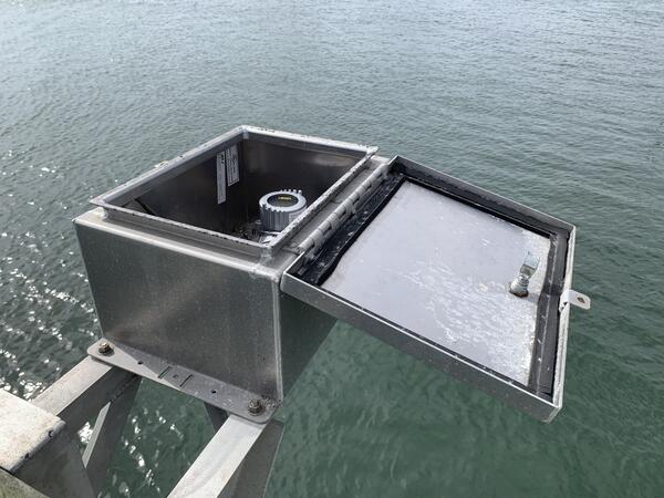
Radar Tide Gage
Looking into the housing box of a radar tide gage deployed at the USGS 01409125 Barnegat Bay at Barnegat Light, New Jersey, tide station.
Looking into the housing box of a radar tide gage deployed at the USGS 01409125 Barnegat Bay at Barnegat Light, New Jersey, tide station.
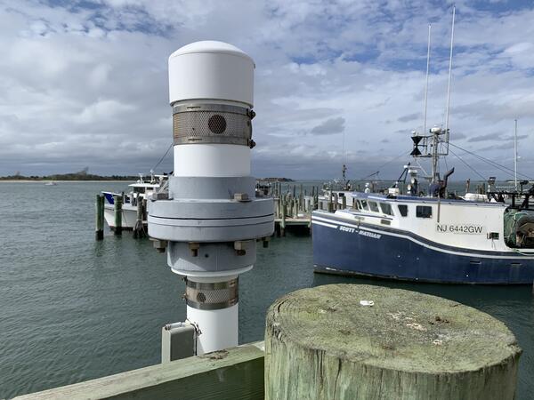
Acoustic Tide Gage
The sensor and vent head of an acoustic type tide gage at USGS 01409125 Barnegat Bay at Barnegat Light, New Jersey.
The sensor and vent head of an acoustic type tide gage at USGS 01409125 Barnegat Bay at Barnegat Light, New Jersey.

Delaware River at Lambertville, NJ and New Hope, PA
Delaware River at Lambertville, NJ and New Hope, PAPhoto of the Deleware River near Lambertville, NJ and New Hope, PA.
Delaware River at Lambertville, NJ and New Hope, PA
Delaware River at Lambertville, NJ and New Hope, PAPhoto of the Deleware River near Lambertville, NJ and New Hope, PA.

NAWQA Sampling
USGS Scientists collecting Biological samples in stream bed
USGS Scientists collecting Biological samples in stream bed

DeadForest3
Sandy roadway through a dead forest in the Sandy Hook National Recreation Area Study Area
Sandy roadway through a dead forest in the Sandy Hook National Recreation Area Study Area

DeadForest4
Sun setting behind a dead forest and scrubland in the Sandy Hook National Recreation Area Study Area
Sun setting behind a dead forest and scrubland in the Sandy Hook National Recreation Area Study Area

Recording Groundwater Levels
USGS Hydrologist Robert Rosman sketching site information at a production well during a water-level-site visit, Camden County.
USGS Hydrologist Robert Rosman sketching site information at a production well during a water-level-site visit, Camden County.

Layne Tapedown
USGS Scientist Robert Rossman checking groundwater levels with a steel tape
USGS Scientist Robert Rossman checking groundwater levels with a steel tape

Worthington groundwater tapedown
USGS Hydrologist Robert Rosman using an electric tape to measure static water level in a production well, Burlington County.
USGS Hydrologist Robert Rosman using an electric tape to measure static water level in a production well, Burlington County.

Pinelands Study Areas
Map depicting the bounderies of the New Jersey Pinelands Management Areas
Map depicting the bounderies of the New Jersey Pinelands Management Areas

NJ tide site
Northeast Region Photo Contest Winner | November 2018 | Honorable Mention
NJ tide site
Northeast Region Photo Contest Winner | November 2018 | Honorable Mention
NJ tide site

Acoustic Doppler Current Profiler (ADCP) boat measurement
Acoustic Doppler Current Profiler (ADCP) boat measurementNortheast Region Photo Contest Winner | June 2019 | Where We Work
Getting ready to begin an Acoustic Doppler Current Profiler (ADCP) boat measurement at 01457500 Delaware River at Riegelsville, NJ
Acoustic Doppler Current Profiler (ADCP) boat measurement
Acoustic Doppler Current Profiler (ADCP) boat measurementNortheast Region Photo Contest Winner | June 2019 | Where We Work
Getting ready to begin an Acoustic Doppler Current Profiler (ADCP) boat measurement at 01457500 Delaware River at Riegelsville, NJ

New Jersey Strata 2
Exposure of the clay-sand facies of the Cohansey Formation in the Kirkwood-Cohansey aquifer system.
Exposure of the clay-sand facies of the Cohansey Formation in the Kirkwood-Cohansey aquifer system.

New Jersey Strata 1
Exposure of the Cape May Formation in the Kirkwood-Cohansey aquifer system.
Exposure of the Cape May Formation in the Kirkwood-Cohansey aquifer system.

WellSensor
Well Pipe with Sonde senor showing set-up at Sandy Hook National Recreation Area, NJ
Well Pipe with Sonde senor showing set-up at Sandy Hook National Recreation Area, NJ

USGS Storm-Tide Sensor
USGS storm-tide sensor bolted to a cement jetty on the Atlantic Ocean coast at Fire Island, New York. USGS scientists deployed over 50 sensors along the coast of Maine, New Hampshire, Massachusetts, Rhode Island, Connecticut, New York, New Jersey and Delaware to study a Nor'easter that affected the Northeast in March of 2018.
USGS storm-tide sensor bolted to a cement jetty on the Atlantic Ocean coast at Fire Island, New York. USGS scientists deployed over 50 sensors along the coast of Maine, New Hampshire, Massachusetts, Rhode Island, Connecticut, New York, New Jersey and Delaware to study a Nor'easter that affected the Northeast in March of 2018.

Equipment preperations
USGS scientist demonstrates the use of a passive seismic tool used for stratigraphy and bedrock mapping to local water officials.
USGS scientist demonstrates the use of a passive seismic tool used for stratigraphy and bedrock mapping to local water officials.

SandyHook Well2
Study Area well pipes in frozen marshy land looking out on Sandy Hook Bay, New Jersey
Study Area well pipes in frozen marshy land looking out on Sandy Hook Bay, New Jersey

SandyHook Well
Study Area well pipe in frozen marshy land looking out on Sandy Hook Bay, New Jersey
Study Area well pipe in frozen marshy land looking out on Sandy Hook Bay, New Jersey

Jonathan Cohl holding a piece of ice at Delaware River
Jonathan Cohl holding a piece of ice at Delaware RiverNortheast Region Photo Contest Winner | March 2019 | People
Jonathan Cohl holding a piece of ice from Delaware River at Frenchtown, NJ
Jonathan Cohl holding a piece of ice at Delaware River
Jonathan Cohl holding a piece of ice at Delaware RiverNortheast Region Photo Contest Winner | March 2019 | People
Jonathan Cohl holding a piece of ice from Delaware River at Frenchtown, NJ